File:Typhoon Chataan 11 july 2002 0120Z.jpg

本预览的尺寸:646 × 599像素。 其他分辨率:259 × 240像素 | 517 × 480像素 | 828 × 768像素 | 1,104 × 1,024像素 | 2,208 × 2,048像素 | 3,730 × 3,460像素。
原始文件 (3,730 × 3,460像素,文件大小:5.06 MB,MIME类型:image/jpeg)
摘要
| 描述 |
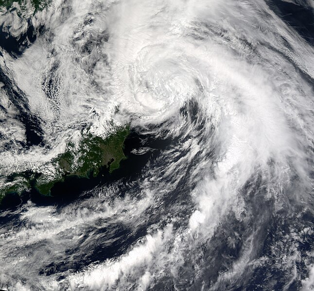
Slowly winding its way down, Typhoon Chataan had dropped to tropical storm status by Thursday, July 11, 2002, when this image from the Moderate Resolution Imaging Spectroradiometer (MODIS) was captured. In the image, the storm is located off the east coast of central Japan in the Pacific Ocean. The storm is much less organized than it was in the previous day's image. Through a gap in the clouds to the southwest of the storm's eye, Tokyo can be seen as a grayish cluster of pixels surrounding a small bay or inlet that protrudes into the island of Honshu. |
|||||
| 日期 | ||||||
| 来源 | http://visibleearth.nasa.gov/view_rec.php?id=3494 | |||||
| 作者 | Image courtesy Jesse Allen, NASA Earth Observatory; data provided by the MODIS Land Rapid Response Team | |||||
| 授权 (二次使用本文件) |
|

文件历史
点击某个日期/时间查看对应时刻的文件。
| 日期/时间 | 缩略图 | 大小 | 用户 | 备注 | |
|---|---|---|---|---|---|
| 当前 | 2015年12月22日 (二) 00:30 | | 3,730 × 3,460(5.06 MB) | Nino Marakot | Cropped |
| 2015年12月21日 (一) 04:39 |  | 5,578 × 4,744(6.9 MB) | Nino Marakot | gonna crop, full image | |
| 2006年12月2日 (六) 16:35 |  | 3,748 × 3,574(2.32 MB) | Good kitty | == Summary == {{Information |Description=Slowly winding its way down, Typhoon Chataan had dropped to tropical storm status by Thursday, July 11, 2002, when this image from the Moderate Resolution Imaging Spectroradiometer (MODIS) was captured. In the imag |
文件用途
以下页面使用本文件:
全域文件用途
以下其他wiki使用此文件:
- en.wikipedia.org上的用途
- es.wikipedia.org上的用途
- vi.wikipedia.org上的用途