File:US Court of Appeals and District Court map.svg

此SVG文件的PNG预览的大小:620 × 402像素。 其他分辨率:320 × 207像素 | 640 × 415像素 | 1,024 × 664像素 | 1,280 × 830像素 | 2,560 × 1,660像素。
原始文件 (SVG文件,尺寸为620 × 402像素,文件大小:768 KB)
摘要
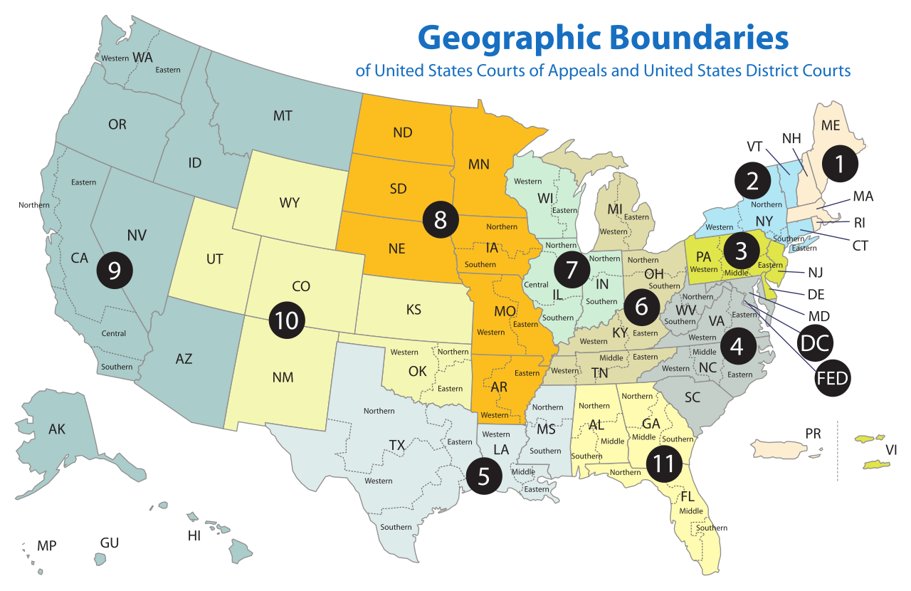
| 描述 | Map of the geographic boundaries of the various United States courts of appeals and United States district courts. |
| 日期 | |
| 来源 | http://www.uscourts.gov/uscourts/images/CircuitMap.pdf |
| 作者 | PDF by the US Government, converted using Texterity's FreeSVG, tweaked using en:Inkscape by Tintazul |
| 其他版本 |
|


许可协议
This work is licensed by the creator under the following conditions:
本文件采用知识共享署名-相同方式共享 2.5 通用许可协议授权。
- 您可以自由地:
- 共享 – 复制、发行并传播本作品
- 修改 – 改编作品
- 惟须遵守下列条件:
- 署名 – 您必须对作品进行署名,提供授权条款的链接,并说明是否对原始内容进行了更改。您可以用任何合理的方式来署名,但不得以任何方式表明许可人认可您或您的使用。
- 相同方式共享 – 如果您再混合、转换或者基于本作品进行创作,您必须以与原先许可协议相同或相兼容的许可协议分发您贡献的作品。
The original work from which this is derived is in the public domain for the following reason:
|
|
 |
文件历史
点击某个日期/时间查看对应时刻的文件。
| 日期/时间 | 缩略图 | 大小 | 用户 | 备注 | |
|---|---|---|---|---|---|
| 当前 | 2018年4月17日 (二) 18:58 | | 620 × 402(768 KB) | BenbowInn | DC and FED are circuits too, added black circles to emphasize them, also converted to plain SVG |
| 2006年7月11日 (二) 07:48 |  | 620 × 402(1.14 MB) | Tintazul | {{Tintazul |Description=Map of the geographic boundaries of the various United States Courts of Appeals and United States District Courts. |Source=[http://www.uscourts.gov/image |
文件用途
超过100个页面使用本文件。 下面的列表只显示使用本文件的前100个页面。完整列表可用。
- 上海美国法院
- 纽约的法院
- 美国乔治亚中区联邦地区法院
- 美国乔治亚北区联邦地区法院
- 美国乔治亚南区联邦地区法院
- 美国亚利桑纳联邦地区法院
- 美国伊利诺伊中区联邦地区法院
- 美国伊利诺伊北区联邦地区法院
- 美国伊利诺伊南区联邦地区法院
- 美国佛罗里达中区联邦地区法院
- 美国佛罗里达北区联邦地区法院
- 美国佛罗里达南区联邦地区法院
- 美国佛蒙特联邦地区法院
- 美国俄亥俄北区联邦地区法院
- 美国俄亥俄南区联邦地区法院
- 美国俄勒冈联邦地区法院
- 美国内华达联邦地区法院
- 美国内布拉斯加联邦地区法院
- 美国加利福尼亚东区联邦地区法院
- 美国加利福尼亚中区联邦地区法院
- 美国加利福尼亚北区联邦地区法院
- 美国加利福尼亚南区联邦地区法院
- 美国北卡罗莱纳东区联邦地区法院
- 美国北卡罗莱纳中区联邦地区法院
- 美国北卡罗莱纳西区联邦地区法院
- 美国北达科他联邦地区法院
- 美国华盛顿东区联邦地区法院
- 美国华盛顿西区联邦地区法院
- 美国南卡罗莱纳联邦地区法院
- 美国南达科他联邦地区法院
- 美国印第安纳北区联邦地区法院
- 美国印第安纳南区联邦地区法院
- 美国夏威夷联邦地区法院
- 美国威斯康辛东区联邦地区法院
- 美国威斯康辛西区联邦地区法院
- 美国宾夕法尼亚东区联邦地区法院
- 美国宾夕法尼亚中区联邦地区法院
- 美国宾夕法尼亚西区联邦地区法院
- 美国密歇根东区联邦地区法院
- 美国密歇根西区联邦地区法院
- 美国密苏里东部联邦地区法院
- 美国密苏里西区联邦地区法院
- 美国密西西比北区联邦地区法院
- 美国密西西比南区联邦地区法院
- 美国康涅狄格联邦地区法院
- 美国弗吉尼亚东区联邦地区法院
- 美国弗吉尼亚西区联邦地区法院
- 美国德克萨斯东区联邦地区法院
- 美国德克萨斯北区联邦地区法院
- 美国德克萨斯南区联邦地区法院
- 美国德克萨斯西区联邦地区法院
- 美国新泽西联邦地区法院
- 美国新罕布什尔联邦地区法院
- 美国明尼苏达联邦地区法院
- 美国波多黎各联邦地区法院
- 美国爱达荷联邦地区法院
- 美国特拉华联邦地区法院
- 美国田纳西东区联邦地区法院
- 美国田纳西中区联邦地区法院
- 美国田纳西西区联邦地区法院
- 美国纽约东区联邦地区法院
- 美国纽约北区联邦地区法院
- 美国纽约南区联邦地区法院
- 美国纽约西区联邦地区法院
- 美国缅因联邦地区法院
- 美国罗德岛联邦地区法院
- 美国联邦上诉法院
- 美国联邦地区法院
- 美国联邦巡回区上诉法院
- 美国联邦第一巡回上诉法院
- 美国联邦第七巡回上诉法院
- 美国联邦第三巡回上诉法院
- 美国联邦第九巡回上诉法院
- 美国联邦第二巡回上诉法院
- 美国联邦第五巡回上诉法院
- 美国联邦第八巡回上诉法院
- 美国联邦第六巡回上诉法院
- 美国联邦第十一巡回上诉法院
- 美国联邦第十巡回上诉法院
- 美国联邦第四巡回上诉法院
- 美国肯塔基东区联邦地区法院
- 美国肯塔基西区联邦地区法院
- 美国艾奥瓦北区联邦地区法院
- 美国艾奥瓦南区联邦地区法院
- 美国蒙大拿联邦地区法院
- 美国西弗吉尼亚北区联邦地区法院
- 美国西弗吉尼亚南区联邦地区法院
- 美国路易斯安那东区联邦地区法院
- 美国路易斯安那中区联邦地区法院
- 美国路易斯安那西区联邦地区法院
- 美国阿拉巴马中区联邦地区法院
- 美国阿拉巴马北区联邦地区法院
- 美国阿拉巴马南区联邦地区法院
- 美国阿拉斯加联邦地区法院
- 美国阿肯色东区联邦地区法院
- 美国阿肯色西区联邦地区法院
- 美国马萨诸塞联邦地区法院
- 美国马里兰联邦地区法院
- 美國地區
- 美國法院
查看连接到这个文件的更多链接。
全域文件用途
以下其他wiki使用此文件:
- ar.wikipedia.org上的用途
- bg.wikipedia.org上的用途
- bn.wikipedia.org上的用途
- ca.wikipedia.org上的用途
- cs.wikipedia.org上的用途
- da.wikipedia.org上的用途
- de.wikipedia.org上的用途
- en.wikipedia.org上的用途
- Federal jurisdiction (United States)
- United States courts of appeals
- United States district court
- United States federal judicial district
- United States Court of Appeals for the Ninth Circuit
- United States Court of Appeals for the Eighth Circuit
- Case citation
- List of regions of the United States
- United States Court of Appeals for the First Circuit
- United States Court of Appeals for the Second Circuit
- United States Court of Appeals for the Third Circuit
- United States Court of Appeals for the Fourth Circuit
- United States Court of Appeals for the Fifth Circuit
- United States Court of Appeals for the Sixth Circuit
- United States Court of Appeals for the Seventh Circuit
- United States Court of Appeals for the Tenth Circuit
- United States Court of Appeals for the Eleventh Circuit
- United States Attorney
- United States Court of Appeals for the District of Columbia Circuit
- Circuit court
- United States District Court for the Southern District of New York
- United States District Court for the Eastern District of Virginia
- United States District Court for the Eastern District of Pennsylvania
- United States District Court for the Central District of California
- List of former United States district courts
- United States District Court for the Western District of New York
- United States District Court for the Eastern District of New York
- United States District Court for the Northern District of New York
- United States District Court for the Middle District of Alabama
- United States District Court for the Southern District of Alabama
- United States District Court for the Northern District of Alabama
- United States District Court for the Southern District of California
- United States District Court for the Southern District of Florida
- United States District Court for the Northern District of California
- United States District Court for the Northern District of Oklahoma
查看本文件的更多全域用途。