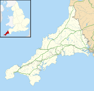
模块:Location map/data/United Kingdom Cornwall (mainland)/doc
这是Module:Location map/data/United Kingdom Cornwall (mainland)的文档页面
| 名称 | 康沃尔郡 | |||
|---|---|---|---|---|
| 边界经纬 | ||||
| 51 | ||||
| -5.8 | ←↕→ | -4.1 | ||
| 49.9 | ||||
| 地图中心 | 50°27′N 4°57′W / 50.45°N 4.95°W | |||
| 图像 | Cornwall UK mainland location map.svg
| |||

| ||||
| 图像1 | Cornwall UK mainland relief location map.jpg
| |||

| ||||
Module:Location map/data/United Kingdom Cornwall (mainland)是用于在康沃尔郡的等距长方投影地图上叠加标记和标签的位置图定义。标记是按默认的地图或类似地图图像上的纬度和经度坐标放置。
使用方法
以下模板均使用名为“United Kingdom Cornwall (mainland)”的参数:
{{Location map | United Kingdom Cornwall (mainland) | ...}}{{Location map many | United Kingdom Cornwall (mainland) | ...}}{{Location map+ | United Kingdom Cornwall (mainland) | ...}}{{Location map~ | United Kingdom Cornwall (mainland) | ...}}
地图定义
name = 康沃爾郡- 用于地图描述的默认值
image = Cornwall UK mainland location map.svg- 默认地图图像,无"Image:"和"File:"前缀
image1 = Cornwall UK mainland relief location map.jpg- 替代地图图像,通常是地形图,可使用
relief或AlternativeMap参数显示出来
- 替代地图图像,通常是地形图,可使用
top = 51
bottom = 49.9- 地图最南端的纬度,以十进制度数显示。
left = -5.8- 地图最西端的经度,以十进制度数显示。
right = -4.1- 地图最东端的经度,以十进制度数显示。
替代地图
{{Location map}}、{{Location map many}}和{{Location map+}}模板可使用参数来指定替代地图图像。image1的地图可以使用relief和AlternativeMap参数显示出来。 您可以在以下模板中找到更多范例:
精度
经度:这张地图从西到东为1.7度。
- 如果图像的宽度为200像素,则为每像素0.0085度。
- 如果图像的宽度为1000像素,则为每像素0.0017度。
纬度:这张地图从北到南为1.1度。
- 如果图像的垂直长度为200像素,则为每像素0.0055度。
- 如果图像的垂直长度为1000像素,则为每像素0.0011度。
参见
位置图模板
- Template:Location map ——使用纬度和经度显示单个标记和标签。
- Template:Location map many ——显示高达9个标记和标签。
- Template:Location map+ ——显示无限数量的标记和标签。