用户:Addis-Bot/20140530/List of airports in Guadeloupe

This is a list of airports in Guadeloupe, sorted by location.
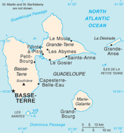
Guadeloupe is an archipelago located in the eastern Caribbean Sea. It is an overseas department (法语:département d'outre-mer or DOM) of France. Guadeloupe department comprises five islands: Basse-Terre Island, Grande-Terre (forming Guadeloupe island) and the dependencies: La Désirade, Les Saintes and Marie-Galante.
Further to the north, Saint-Barthélemy and the French part of Saint Martin once came under the jurisdiction of Guadeloupe, but each is now an overseas collectivity (collectivités d'outre-mer or COM) of France.
Airports
编辑ICAO location identifiers are linked to each airport's Aeronautical Information Publication (AIP), which are available online in Portable Document Format (PDF) from the French Service d'information aéronautique (SIA).
See also
编辑References
编辑- Aeronautical Information Service / Service d'information aéronautique (SIA) (英文)
- Union des Aéroports Français (法文)
- Great Circle Mapper: Guadeloupe
- World Aero Data: Guadeloupe
Notes
编辑- ^ 在大圆制图人(Great Circle Mapper)上的BBR机场信息 (来源:DAFIF 2006年10月生效).
- 维基百科Discord、IRC、LINE、QQ及Telegram等各平台交流群欢迎大家加入。
- 维基百科志愿者互联交流群(Telegram:@wikipedia_zh_n、Discord及IRC:#wikipedia-zh IRC://互联)欢迎大家加入。
- 中文维基百科Facebook粉丝专页正式上线,邀请大家一同关注。
- 《维基人》长期征稿中,欢迎投稿。
- 香港维基社群用户组的Instagram、Telegram频道正式上线,邀请大家一同关注。
- 台湾维基社群Telegram 聊天室欢迎大家加入。
- 台湾知识种子计划(WSOTK)志工召募中,请参看WSOTK粉丝团。
- 维基台北写作聚于每月第二个礼拜六举行,欢迎报名参与。
- 台北 OSM x WikiData 聚会每月举行,详情请到粉丝页查询。
- 欢迎关注维基媒体台中社群计划页面与粉丝专页。
- MoWiki维基编辑定期聚每月第三个星期六于台中举办,欢迎报名参加和关注我们。
- 高雄维基社群启动“高知识”计划,每月第三个周六14:00线上聚会。欢迎了解详情。
- 国立台湾大学维基研究社现正招募社员,欢迎报名入社!另请参阅Facebook粉丝专页及Instagram账号。
- 用于讨论管理员事务的邮箱列表wikipedia-zh-admin lists.wikimedia.org已建立,欢迎各位管理员加入。
- Unblock-zh.org正在试运行。欢迎希望参与的管理员根据教程注册账户、取得权限,并处理工单。
- ^ 在大圆制图人(Great Circle Mapper)上的DSD机场信息 (来源:DAFIF 2006年10月生效).
- 维基百科Discord、IRC、LINE、QQ及Telegram等各平台交流群欢迎大家加入。
- 维基百科志愿者互联交流群(Telegram:@wikipedia_zh_n、Discord及IRC:#wikipedia-zh IRC://互联)欢迎大家加入。
- 中文维基百科Facebook粉丝专页正式上线,邀请大家一同关注。
- 《维基人》长期征稿中,欢迎投稿。
- 香港维基社群用户组的Instagram、Telegram频道正式上线,邀请大家一同关注。
- 台湾维基社群Telegram 聊天室欢迎大家加入。
- 台湾知识种子计划(WSOTK)志工召募中,请参看WSOTK粉丝团。
- 维基台北写作聚于每月第二个礼拜六举行,欢迎报名参与。
- 台北 OSM x WikiData 聚会每月举行,详情请到粉丝页查询。
- 欢迎关注维基媒体台中社群计划页面与粉丝专页。
- MoWiki维基编辑定期聚每月第三个星期六于台中举办,欢迎报名参加和关注我们。
- 高雄维基社群启动“高知识”计划,每月第三个周六14:00线上聚会。欢迎了解详情。
- 国立台湾大学维基研究社现正招募社员,欢迎报名入社!另请参阅Facebook粉丝专页及Instagram账号。
- 用于讨论管理员事务的邮箱列表wikipedia-zh-admin lists.wikimedia.org已建立,欢迎各位管理员加入。
- Unblock-zh.org正在试运行。欢迎希望参与的管理员根据教程注册账户、取得权限,并处理工单。
- ^ 在大圆制图人(Great Circle Mapper)上的GBJ机场信息 (来源:DAFIF 2006年10月生效).
- 维基百科Discord、IRC、LINE、QQ及Telegram等各平台交流群欢迎大家加入。
- 维基百科志愿者互联交流群(Telegram:@wikipedia_zh_n、Discord及IRC:#wikipedia-zh IRC://互联)欢迎大家加入。
- 中文维基百科Facebook粉丝专页正式上线,邀请大家一同关注。
- 《维基人》长期征稿中,欢迎投稿。
- 香港维基社群用户组的Instagram、Telegram频道正式上线,邀请大家一同关注。
- 台湾维基社群Telegram 聊天室欢迎大家加入。
- 台湾知识种子计划(WSOTK)志工召募中,请参看WSOTK粉丝团。
- 维基台北写作聚于每月第二个礼拜六举行,欢迎报名参与。
- 台北 OSM x WikiData 聚会每月举行,详情请到粉丝页查询。
- 欢迎关注维基媒体台中社群计划页面与粉丝专页。
- MoWiki维基编辑定期聚每月第三个星期六于台中举办,欢迎报名参加和关注我们。
- 高雄维基社群启动“高知识”计划,每月第三个周六14:00线上聚会。欢迎了解详情。
- 国立台湾大学维基研究社现正招募社员,欢迎报名入社!另请参阅Facebook粉丝专页及Instagram账号。
- 用于讨论管理员事务的邮箱列表wikipedia-zh-admin lists.wikimedia.org已建立,欢迎各位管理员加入。
- Unblock-zh.org正在试运行。欢迎希望参与的管理员根据教程注册账户、取得权限,并处理工单。
- ^ 在大圆制图人(Great Circle Mapper)上的PTP机场信息 (来源:DAFIF 2006年10月生效).
- 维基百科Discord、IRC、LINE、QQ及Telegram等各平台交流群欢迎大家加入。
- 维基百科志愿者互联交流群(Telegram:@wikipedia_zh_n、Discord及IRC:#wikipedia-zh IRC://互联)欢迎大家加入。
- 中文维基百科Facebook粉丝专页正式上线,邀请大家一同关注。
- 《维基人》长期征稿中,欢迎投稿。
- 香港维基社群用户组的Instagram、Telegram频道正式上线,邀请大家一同关注。
- 台湾维基社群Telegram 聊天室欢迎大家加入。
- 台湾知识种子计划(WSOTK)志工召募中,请参看WSOTK粉丝团。
- 维基台北写作聚于每月第二个礼拜六举行,欢迎报名参与。
- 台北 OSM x WikiData 聚会每月举行,详情请到粉丝页查询。
- 欢迎关注维基媒体台中社群计划页面与粉丝专页。
- MoWiki维基编辑定期聚每月第三个星期六于台中举办,欢迎报名参加和关注我们。
- 高雄维基社群启动“高知识”计划,每月第三个周六14:00线上聚会。欢迎了解详情。
- 国立台湾大学维基研究社现正招募社员,欢迎报名入社!另请参阅Facebook粉丝专页及Instagram账号。
- 用于讨论管理员事务的邮箱列表wikipedia-zh-admin lists.wikimedia.org已建立,欢迎各位管理员加入。
- Unblock-zh.org正在试运行。欢迎希望参与的管理员根据教程注册账户、取得权限,并处理工单。
- ^ 在大圆制图人(Great Circle Mapper)上的SFC机场信息 (来源:DAFIF 2006年10月生效).
- 维基百科Discord、IRC、LINE、QQ及Telegram等各平台交流群欢迎大家加入。
- 维基百科志愿者互联交流群(Telegram:@wikipedia_zh_n、Discord及IRC:#wikipedia-zh IRC://互联)欢迎大家加入。
- 中文维基百科Facebook粉丝专页正式上线,邀请大家一同关注。
- 《维基人》长期征稿中,欢迎投稿。
- 香港维基社群用户组的Instagram、Telegram频道正式上线,邀请大家一同关注。
- 台湾维基社群Telegram 聊天室欢迎大家加入。
- 台湾知识种子计划(WSOTK)志工召募中,请参看WSOTK粉丝团。
- 维基台北写作聚于每月第二个礼拜六举行,欢迎报名参与。
- 台北 OSM x WikiData 聚会每月举行,详情请到粉丝页查询。
- 欢迎关注维基媒体台中社群计划页面与粉丝专页。
- MoWiki维基编辑定期聚每月第三个星期六于台中举办,欢迎报名参加和关注我们。
- 高雄维基社群启动“高知识”计划,每月第三个周六14:00线上聚会。欢迎了解详情。
- 国立台湾大学维基研究社现正招募社员,欢迎报名入社!另请参阅Facebook粉丝专页及Instagram账号。
- 用于讨论管理员事务的邮箱列表wikipedia-zh-admin lists.wikimedia.org已建立,欢迎各位管理员加入。
- Unblock-zh.org正在试运行。欢迎希望参与的管理员根据教程注册账户、取得权限,并处理工单。
- ^ 在大圆制图人(Great Circle Mapper)上的LSS机场信息 (来源:DAFIF 2006年10月生效).
- 维基百科Discord、IRC、LINE、QQ及Telegram等各平台交流群欢迎大家加入。
- 维基百科志愿者互联交流群(Telegram:@wikipedia_zh_n、Discord及IRC:#wikipedia-zh IRC://互联)欢迎大家加入。
- 中文维基百科Facebook粉丝专页正式上线,邀请大家一同关注。
- 《维基人》长期征稿中,欢迎投稿。
- 香港维基社群用户组的Instagram、Telegram频道正式上线,邀请大家一同关注。
- 台湾维基社群Telegram 聊天室欢迎大家加入。
- 台湾知识种子计划(WSOTK)志工召募中,请参看WSOTK粉丝团。
- 维基台北写作聚于每月第二个礼拜六举行,欢迎报名参与。
- 台北 OSM x WikiData 聚会每月举行,详情请到粉丝页查询。
- 欢迎关注维基媒体台中社群计划页面与粉丝专页。
- MoWiki维基编辑定期聚每月第三个星期六于台中举办,欢迎报名参加和关注我们。
- 高雄维基社群启动“高知识”计划,每月第三个周六14:00线上聚会。欢迎了解详情。
- 国立台湾大学维基研究社现正招募社员,欢迎报名入社!另请参阅Facebook粉丝专页及Instagram账号。
- 用于讨论管理员事务的邮箱列表wikipedia-zh-admin lists.wikimedia.org已建立,欢迎各位管理员加入。
- Unblock-zh.org正在试运行。欢迎希望参与的管理员根据教程注册账户、取得权限,并处理工单。