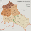
File:General Government for the occupied Polish territories (1941).png

本预览的尺寸:605 × 600像素。 其他分辨率:242 × 240像素 | 484 × 480像素 | 774 × 768像素 | 1,033 × 1,024像素 | 2,299 × 2,280像素。
原始文件 (2,299 × 2,280像素,文件大小:543 KB,MIME类型:image/png)
文件历史
点击某个日期/时间查看对应时刻的文件。
| 日期/时间 | 缩略图 | 大小 | 用户 | 备注 | |
|---|---|---|---|---|---|
| 当前 | 2014年5月8日 (四) 15:33 |  | 2,299 × 2,280(543 KB) | Poeticbent | legend |
| 2014年3月18日 (二) 16:48 |  | 2,299 × 2,280(453 KB) | Poeticbent | =={{int:filedesc}}== {{Information |description={{en|1=Map of the administrative areas of the General Government}} |date=2012-05-26 |source={{own}} by {{u|XrysD}}, edited by {{u|Poeticbent}} with superimposed German-Soviet border before Operation Barba... |
文件用途
以下页面使用本文件:
全域文件用途
以下其他wiki使用此文件:
- ar.wikipedia.org上的用途
- azb.wikipedia.org上的用途
- en.wikipedia.org上的用途
- es.wikipedia.org上的用途
- fr.wikipedia.org上的用途
- it.wikipedia.org上的用途
- no.wikipedia.org上的用途
- pl.wikipedia.org上的用途
- pt.wikipedia.org上的用途
- ru.wikipedia.org上的用途
- www.wikidata.org上的用途

