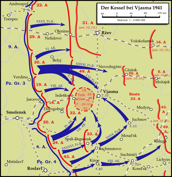
File:Karte - Kesselschlacht bei Vjasma 1941.png

本预览的尺寸:583 × 600像素。 其他分辨率:233 × 240像素 | 467 × 480像素 | 747 × 768像素 | 1,047 × 1,077像素。
原始文件 (1,047 × 1,077像素,文件大小:338 KB,MIME类型:image/png)
文件历史
点击某个日期/时间查看对应时刻的文件。
| 日期/时间 | 缩略图 | 大小 | 用户 | 备注 | |
|---|---|---|---|---|---|
| 当前 | 2024年1月13日 (六) 22:19 |  | 1,047 × 1,077(338 KB) | Андрей Романенко | some names and locations corrected |
| 2015年5月31日 (日) 22:01 |  | 1,047 × 1,077(333 KB) | Cmdrjameson | Compressed with pngout. Reduced by 140kB (29% decrease). | |
| 2009年9月13日 (日) 22:53 |  | 1,047 × 1,077(474 KB) | Memnon335bc | {{Information |Description={{en|1=Map showing the Battle near Vyazma (October 2nd — October 20th 1941) during the Second World War (1939—1945) at the Eastern Front. The map is created by Inkscape and is based on the Map 30 in the attachement of the bo |
文件用途
以下页面使用本文件:
全域文件用途
以下其他wiki使用此文件:
- bg.wikipedia.org上的用途
- de.wikipedia.org上的用途
- en.wikipedia.org上的用途
- es.wikipedia.org上的用途
- et.wikipedia.org上的用途
- fa.wikipedia.org上的用途
- fi.wikipedia.org上的用途
- he.wikipedia.org上的用途
- it.wikipedia.org上的用途
- mn.wikipedia.org上的用途
- nl.wikipedia.org上的用途
- ru.wikipedia.org上的用途
- tr.wikipedia.org上的用途
- uk.wikipedia.org上的用途
- vi.wikipedia.org上的用途
- www.wikidata.org上的用途

