File:Kosovo location map.svg

此SVG文件的PNG预览的大小:529 × 599像素。 其他分辨率:212 × 240像素 | 424 × 480像素 | 678 × 768像素 | 904 × 1,024像素 | 1,808 × 2,048像素 | 1,015 × 1,150像素。
原始文件 (SVG文件,尺寸为1,015 × 1,150像素,文件大小:149 KB)

|
The boundaries on this map show the de facto situation. This is just one of several different views on the subject (see COM:NPOV). |
摘要
| 描述 |
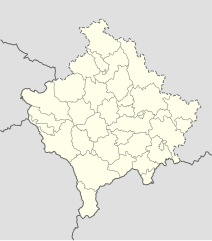
Deutsch: Positionskarte des Kosovo
Quadratische Plattkarte, N-S-Streckung 140 %. Geographische Begrenzung der Karte:
English: Location map of Kosovo
Equirectangular projection, N/S stretching 140 %. Geographic limits of the map:
|
| 日期 | 01-08-2008 |
| 来源 | own work, using United States National Imagery and Mapping Agency data |
| 作者 | NordNordWest |

|
|
许可协议
我,本作品著作权人,特此采用以下许可协议发表本作品:

|
已授权您依据自由软件基金会发行的无固定段落及封面封底文字(Invariant Sections, Front-Cover Texts, and Back-Cover Texts)的GNU自由文件许可协议1.2版或任意后续版本的条款,复制、传播和/或修改本文件。该协议的副本请见“GNU Free Documentation License”。 |
本文件采用知识共享署名-相同方式共享 3.0 未本地化版本许可协议授权。
- 您可以自由地:
- 共享 – 复制、发行并传播本作品
- 修改 – 改编作品
- 惟须遵守下列条件:
- 署名 – 您必须对作品进行署名,提供授权条款的链接,并说明是否对原始内容进行了更改。您可以用任何合理的方式来署名,但不得以任何方式表明许可人认可您或您的使用。
- 相同方式共享 – 如果您再混合、转换或者基于本作品进行创作,您必须以与原先许可协议相同或相兼容的许可协议分发您贡献的作品。
您可以选择您需要的许可协议。
文件历史
点击某个日期/时间查看对应时刻的文件。
| 日期/时间 | 缩略图 | 大小 | 用户 | 备注 | |
|---|---|---|---|---|---|
| 当前 | 2016年12月15日 (四) 16:53 | | 1,015 × 1,150(149 KB) | NordNordWest | Reverted to version as of 10:16, 13 December 2016 (UTC); yeah, strange, try official maps; and now stop changing this map without a discussion _before_ |
| 2016年12月15日 (四) 14:08 |  | 1,015 × 1,150(103 KB) | AceDouble | Reverted to version as of 22:04, 12 December 2016 (UTC) Strange boundaries!? that's a funny one. Check it here> http://www.balgoc.org.tr/harita/kosova.jpg | |
| 2016年12月13日 (二) 10:16 |  | 1,015 × 1,150(149 KB) | NordNordWest | Reverted to version as of 13:03, 23 November 2009 (UTC); no need for different colours, strange boundaries | |
| 2016年12月12日 (一) 22:04 |  | 1,015 × 1,150(103 KB) | AceDouble | update | |
| 2009年11月23日 (一) 13:03 |  | 1,015 × 1,150(149 KB) | NordNordWest | update | |
| 2009年5月6日 (三) 18:49 |  | 1,016 × 1,150(198 KB) | NordNordWest | more detailed | |
| 2008年8月29日 (五) 08:04 |  | 1,016 × 1,150(78 KB) | NordNordWest | ||
| 2008年8月1日 (五) 17:41 |  | 339 × 383(77 KB) | NordNordWest | {{Information |Description= {{de|Positionskarte des Kosovo}} Quadratische Plattkarte, N-S-Streckung 140 %. Geographische Begrenzung der Karte: * N: 43.4° N * S: 41.7° N * W: 19.8° O * O: 21.9° O {{en|Location map of [[:en:Kosovo|Kosovo] |
文件用途
没有页面使用本文件。
全域文件用途
以下其他wiki使用此文件:
- de.wikipedia.org上的用途
- eo.wikipedia.org上的用途
- es.wikipedia.org上的用途
- fr.wikipedia.org上的用途
- mt.wikipedia.org上的用途
- pl.wikipedia.org上的用途
- ru.wikipedia.org上的用途
- sv.wikipedia.org上的用途
- uk.wikipedia.org上的用途