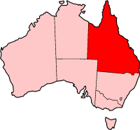
File:QLD in Australia map.png
QLD_in_Australia_map.png (200 × 186像素,文件大小:11 KB,MIME类型:image/png)
文件历史
点击某个日期/时间查看对应时刻的文件。
| 日期/时间 | 缩略图 | 大小 | 用户 | 备注 | |
|---|---|---|---|---|---|
| 当前 | 2004年11月30日 (二) 09:23 |  | 200 × 186(11 KB) | Jeroen | from en |
文件用途
以下49个页面使用本文件:
- 中央高地區政府
- 伊薩山市政府
- 伯德金郡政府
- 克羅伊登郡政府
- 克隆克里郡政府
- 凱恩斯區政府
- 北貝納區政府
- 南原區政府
- 南貝納區政府
- 卡奔塔利亞郡政府
- 圖翁巴區政府
- 奎爾皮郡政府
- 威桑迪區政府
- 巴隆郡政府
- 布魯郡政府
- 帕魯郡政府
- 庫克郡政府
- 摩寧頓郡政府
- 杜馬吉原住民郡政府
- 查特斯塔區政府
- 查茨沃思 (昆士兰州)
- 格列士敦區政府
- 桂格理平原
- 棕櫚島原住民郡政府
- 波姆浦洛原住民郡政府
- 洛吉爾谷區政府
- 洛坎普頓區政府
- 溫頓郡政府
- 班德堡區政府
- 瑪拉諾亞區政府
- 福林德斯郡政府
- 福瑞沙海岸區政府
- 索美塞區政府
- 聖靈群島
- 艾薩克區
- 西原區政府
- 西斯寧緣區政府
- 貢迪溫迪區政府
- 里奇蒙郡政府
- 金皮區政府
- 陽光海岸區政府
- 雅拉巴原住民郡政府
- 食火雞海岸區政府
- 香蕉郡政府
- 高原區政府
- 高旺亞馬原住民郡政府
- 麥金利郡政府
- 默韦郡政府
- Template:Queensland-geo-stub
全域文件用途
以下其他wiki使用此文件:
- cs.wikipedia.org上的用途
- de.wikinews.org上的用途
- en.wikipedia.org上的用途
- Bang Bang Jump Up
- Wikipedia talk:WikiProject Maps/Archive1
- List of highways in Queensland
- Canterbury, Queensland
- Island Head (Queensland)
- Template:Queensland-geo-stub
- Shrewsbury Rock
- Wunjunga, Queensland
- Wolf Rock (Queensland)
- Hays Inlet
- Bountiful Islands
- Agnes Island
- Hudson Island
- Kumboola Island
- Sisters Island (Queensland)
- Kent Island (Queensland)
- Jessie Island
- Lindquist Island
- Russell Island (Frankland Islands)
- Round Island (Queensland)
- Mabel Island
- Normanby Island (Queensland)
- Woody Island (Queensland)
- Struck Island
- Rocky Island (Queensland)
- County of Canning
- Low Wooded Island
- South Direction Island
- North Direction Island
- Murdock Island
- Magra Islet
- Macarthur Islands (Queensland)
- Cholmondeley Islet
- Halfway Island (Queensland)
- Leichhardt Falls
- The Three Sisters (Queensland)
- Cape Capricorn
- Cape Manifold
- Gebar Island
- Turnagain Island (Queensland)
- Talbot Islands
- Captains Mountain
- Mount Quincan
- Talk:Aussie salute
- Mount Hopeless (Queensland)
- Combo Waterhole
- Batt Reef
- Ross River, Queensland
查看此文件的更多全域用途。


