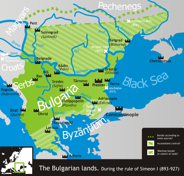
File:Bulgaria Simeon I (893-927).svg

此SVG文件的PNG预览的大小:627 × 599像素。 其他分辨率:251 × 240像素 | 502 × 480像素 | 803 × 768像素 | 1,071 × 1,024像素 | 2,142 × 2,048像素 | 752 × 719像素。
原始文件 (SVG文件,尺寸为752 × 719像素,文件大小:232 KB)
文件历史
点击某个日期/时间查看对应时刻的文件。
| 日期/时间 | 缩略图 | 大小 | 用户 | 备注 | |
|---|---|---|---|---|---|
| 当前 | 2019年11月18日 (一) 14:50 |  | 752 × 719(232 KB) | Claude Zygiel | Side |
| 2019年11月18日 (一) 14:49 |  | 744 × 1,052(520 KB) | Claude Zygiel | Details | |
| 2011年2月18日 (五) 20:38 |  | 752 × 719(232 KB) | Ilmari Karonen | add missing xmlns attribute(s) | |
| 2007年3月7日 (三) 20:49 | 没有缩略图 | (232 KB) | Martyr | ||
| 2007年3月6日 (二) 09:13 | 没有缩略图 | (232 KB) | Martyr | ||
| 2007年3月5日 (一) 21:10 | 没有缩略图 | (230 KB) | Martyr | ||
| 2007年3月5日 (一) 20:03 | 没有缩略图 | (230 KB) | Martyr | larger names of battles, etc. | |
| 2007年3月5日 (一) 19:29 | 没有缩略图 | (232 KB) | Martyr | names of some important battles, etc. | |
| 2007年3月5日 (一) 10:22 | 没有缩略图 | (211 KB) | Martyr | river names, Thessaloniki name, rm line (northern border is conjectural), etc. | |
| 2007年3月4日 (日) 20:59 | 没有缩略图 | (194 KB) | Martyr | new |
文件用途
以下页面使用本文件:
全域文件用途
以下其他wiki使用此文件:
- ar.wikipedia.org上的用途
- bn.wikipedia.org上的用途
- ckb.wikipedia.org上的用途
- da.wikipedia.org上的用途
- de.wikipedia.org上的用途
- el.wikipedia.org上的用途
- en.wikipedia.org上的用途
- eo.wikipedia.org上的用途
- es.wikipedia.org上的用途
- eu.wikipedia.org上的用途
- fa.wikipedia.org上的用途
- fr.wikipedia.org上的用途
- he.wikipedia.org上的用途
- hr.wikipedia.org上的用途
- hy.wikipedia.org上的用途
- it.wikipedia.org上的用途
- ja.wikipedia.org上的用途
- ka.wikipedia.org上的用途
- kk.wikipedia.org上的用途
- lt.wikipedia.org上的用途
- lv.wikipedia.org上的用途
- mk.wikipedia.org上的用途
- nds.wikipedia.org上的用途
- nl.wikipedia.org上的用途
- no.wikipedia.org上的用途
- oc.wikipedia.org上的用途
- pl.wikipedia.org上的用途
- pt.wikipedia.org上的用途
查看此文件的更多全域用途。


