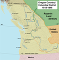
File:Oregoncountry2.png

本预览的尺寸:588 × 599像素。 其他分辨率:235 × 240像素 | 471 × 480像素 | 992 × 1,011像素。
原始文件 (992 × 1,011像素,文件大小:1.04 MB,MIME类型:image/png)
文件历史
点击某个日期/时间查看对应时刻的文件。
| 日期/时间 | 缩略图 | 大小 | 用户 | 备注 | |
|---|---|---|---|---|---|
| 当前 | 2017年5月20日 (六) 16:03 |  | 992 × 1,011(1.04 MB) | Ras67 | cropped |
| 2008年8月28日 (四) 18:37 |  | 1,000 × 1,019(1.24 MB) | Kmusser | Added York Factory Express and increased resolution | |
| 2006年4月10日 (一) 12:42 |  | 593 × 600(132 KB) | Kmusser | ||
| 2006年4月6日 (四) 19:11 |  | 593 × 600(133 KB) | Kmusser | This map shows Oregon Country, 1818-1846. |
文件用途
以下页面使用本文件:
全域文件用途
以下其他wiki使用此文件:
- ar.wikipedia.org上的用途
- bn.wikipedia.org上的用途
- ca.wikipedia.org上的用途
- cs.wikipedia.org上的用途
- cy.wikipedia.org上的用途
- de.wikipedia.org上的用途
- en.wikipedia.org上的用途
- James K. Polk
- History of Canada
- Continental Divide of the Americas
- Rupert's Land
- Fort Vancouver
- Oregon Country
- Historical regions of the United States
- History of British Columbia
- Jason Lee (missionary)
- Spanish Canadians
- User:Kmusser/Images
- John Floyd (Virginia politician)
- Columbia District
- Cascadia movement
- Presidency of James K. Polk
- User:EncMstr/sandbox
- James Sinclair (fur trader)
- Canadian canoe routes
- User:Kayoty/sandbox
- Native American peoples of Oregon
- History of U.S. foreign policy, 1829–1861
- User:Falcaorib/Canada, United States and Mexico
- en.wikibooks.org上的用途
- en.wiktionary.org上的用途
- es.wikipedia.org上的用途
- fa.wikipedia.org上的用途
- fr.wikipedia.org上的用途
查看此文件的更多全域用途。
