File:PortlandBillAndChesilBeach(Landsat).jpg

本预览的尺寸:618 × 600像素。 其他分辨率:247 × 240像素 | 495 × 480像素 | 940 × 912像素。
原始文件 (940 × 912像素,文件大小:372 KB,MIME类型:image/jpeg)
.jpg?uselang=zh-hans)
.jpg?uselang=zh-hans)
.jpg?action=history&uselang=zh-hans)
.jpg)
| 描述 |
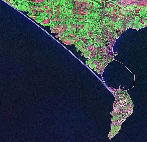
English: Screenshot from World Wind software displaying NASA Landsat imagery. The website says "The Landsat Global Mosaic, Blue Marble, and the USGS raster maps and images are all Public Domain." (http://www.worldwindcentral.com/wiki/World_Wind_FAQ) |
| 来源 | Satellite imagery taken from NASA World Wind software (by screenshot) |
| 作者 | 相片: NASA |
许可协议
| 本图像属于 w:公有领域 ,因其为 NASA 的 World Wind 卫星地图浏览器的一张截图,且使用了公有领域图层,如 Blue Marble、MODIS、Landsat、SRTM、USGS、GLOBE 等。
|
 |
原始上传日志
The original description page was here. All following user names refer to en.wikipedia.
- 2006-04-21 07:42 Euchiasmus 940×912× (381170 bytes) Screenshot from World Wind software displaying NASA Landsat imagery. The website says "The Landsat Global Mosaic, Blue Marble, and the USGS raster maps and images are all Public Domain." (http://www.worldwindcentral.com/wiki/World_Wind_FAQ)
文件历史
点击某个日期/时间查看对应时刻的文件。
| 日期/时间 | 缩略图 | 大小 | 用户 | 备注 | |
|---|---|---|---|---|---|
| 当前 | 2009年8月13日 (四) 14:24 | | 940 × 912(372 KB) | Kordas | {{Information |Description={{en|Screenshot from World Wind software displaying NASA Landsat imagery. The website says "The Landsat Global Mosaic, Blue Marble, and the USGS raster maps and images are all Public Domain." (http://www.worldwindcentral.com/wik |
文件用途
以下页面使用本文件:
全域文件用途
以下其他wiki使用此文件:
- br.wikipedia.org上的用途
- de.wikipedia.org上的用途
- en.wikipedia.org上的用途
- et.wikipedia.org上的用途
- ko.wikipedia.org上的用途
- simple.wikipedia.org上的用途
.jpg)