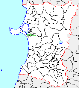
Akita_Showa.png (264 × 294 像素,檔案大小:5 KB,MIME 類型:image/png


摘要

描述
English: Akita Showa
日本語: 秋田県昭和町、県内位置図
來源 File:Japan map.png
作者
  • 改変元:著作権・使用制限テンプレート参照
  • 改変部分:アップロード者
授權許可
(重用此檔案)

This file is derivated from File:Japan map.png. The source and authors of the original map are as follow:

The original file is licensed {{GFDL}} and {{Cc-by-sa-3.0}}. The changes made based on the original file are as follow: Minor changes are {{PD-ineligible}} meaning the file is GFDL and Cc-by-sa-3.0. Bigger changes made before August 1, 2009 or after September 30, 2020 are licensed GFDL and Cc-by-sa-3.0 like the original file. Bigger changes made by the uploader between August 1, 2009 and September 30, 2020 (inclusive) are licensed GFDL only. In some cases the uploader added further licenses for the changes and in that case the licenses are specified below.
此標籤不表示文件的著作權狀態。任何文件在附有此標籤的同時還需要一個有效的著作權標籤請參閱許可協議說明頁面以了解更多資訊。

授權條款

GNU head 已授權您依據自由軟體基金會發行的無固定段落、封面文字和封底文字GNU自由文件授權條款1.2版或任意後續版本,對本檔進行複製、傳播和/或修改。該協議的副本列在GNU自由文件授權條款中。
w:zh:創用CC
姓名標示 相同方式分享
您可以自由:
  • 分享 – 複製、發佈和傳播本作品
  • 重新修改 – 創作演繹作品
惟需遵照下列條件:
  • 姓名標示 – 您必須指名出正確的製作者,和提供授權條款的連結,以及表示是否有對內容上做出變更。您可以用任何合理的方式來行動,但不得以任何方式表明授權條款是對您許可或是由您所使用。
  • 相同方式分享 – 如果您利用本素材進行再混合、轉換或創作,您必須基於如同原先的相同或兼容的條款,來分布您的貢獻成品。

原始上傳日誌

The original description page was here. All following user names refer to ja.wikipedia.
  • 2004-09-20 18:13 Koba-chan 264×294× (5560 bytes) 秋田県昭和町、市町村境界図。海岸線を青色。田沢湖・八郎潟調整池を加筆
  • 2003-12-16 15:41 Koba-chan 264×294× (5375 bytes) 秋田県昭和町、県内位置図
  • 2003-12-15 17:30 Koba-chan 264×294× (5262 bytes) 秋田県昭和町、県内位置図


This file was moved from Japanese Wikipedia.

See below for original file information.

File name

Akita Showa.png

Description

秋田県昭和町、県内位置図 {{Japan map}}

File history
日期/時間 (UTC) 尺寸 使用者 備⁠註
2003年12月15日, 17:30:28 264x294 Koba-chan 秋田県昭和町、県内位置図
2003年12月16日, 15:41:22 264x294 Koba-chan 秋田県昭和町、県内位置図
2004年9月20日, 18:13:25 264x294 Koba-chan 秋田県昭和町、市町村境界図。海岸線を青色。田沢湖・八郎潟調整池を加筆
Page history
日期/時間 (UTC) Flag 使用者 摘要:
2003年12月15日, 17:30:28 Koba-chan 秋田県昭和町、県内位置図
2006年3月16日, 06:17:38 Cheebot cheebot - {{Japan map}}

Deutsch  English  فارسی  日本語  한국어  македонски  +/−

說明

添加單行說明來描述出檔案所代表的內容

在此檔案描寫的項目

描繪內容

0fd85b5587fd2d2a7b63f3f07de4e9215d027967

斷定方法:​SHA-1 中文 (已轉換拼寫)

5,560 位元組

294 像素

264 像素

檔案歷史

點選日期/時間以檢視該時間的檔案版本。

日期/時間縮⁠圖尺寸使用者備⁠註
目前2020年10月12日 (一) 20:31於 2020年10月12日 (一) 20:31 版本的縮圖264 × 294(5 KB)OgreBot(BOT): Reverting to most recent version before archival
2020年10月12日 (一) 20:31於 2020年10月12日 (一) 20:31 版本的縮圖264 × 294(5 KB)OgreBot(BOT): Uploading old version of file from ja.wikipedia; originally uploaded on 2003-12-16 15:41:22 by Koba-chan
2020年10月12日 (一) 20:31於 2020年10月12日 (一) 20:31 版本的縮圖264 × 294(5 KB)OgreBot(BOT): Uploading old version of file from ja.wikipedia; originally uploaded on 2003-12-15 17:30:28 by Koba-chan
2020年5月27日 (三) 09:27於 2020年5月27日 (三) 09:27 版本的縮圖264 × 294(5 KB)NtsctalkUploaded a work by https://ja.wikipedia.org/wiki/%E5%88%A9%E7%94%A8%E8%80%85:Koba-chan from https://ja.wikipedia.org/wiki/%E3%83%95%E3%82%A1%E3%82%A4%E3%83%AB:Akita_Showa.png with UploadWizard
2004年9月20日 (一) 18:13於 2004年9月20日 (一) 18:13 版本的縮圖264 × 294(5 KB)Koba-chan秋田県昭和町、市町村境界図。海岸線を青色。田沢湖・八郎潟調整池を加筆
2003年12月16日 (二) 15:41於 2003年12月16日 (二) 15:41 版本的縮圖264 × 294(5 KB)Koba-chan秋田県昭和町、県内位置図
2003年12月15日 (一) 17:30於 2003年12月15日 (一) 17:30 版本的縮圖264 × 294(5 KB)Koba-chan秋田県昭和町、県内位置図

下列頁面有用到此檔案:

全域檔案使用狀況

以下其他 wiki 使用了這個檔案:

詮釋資料