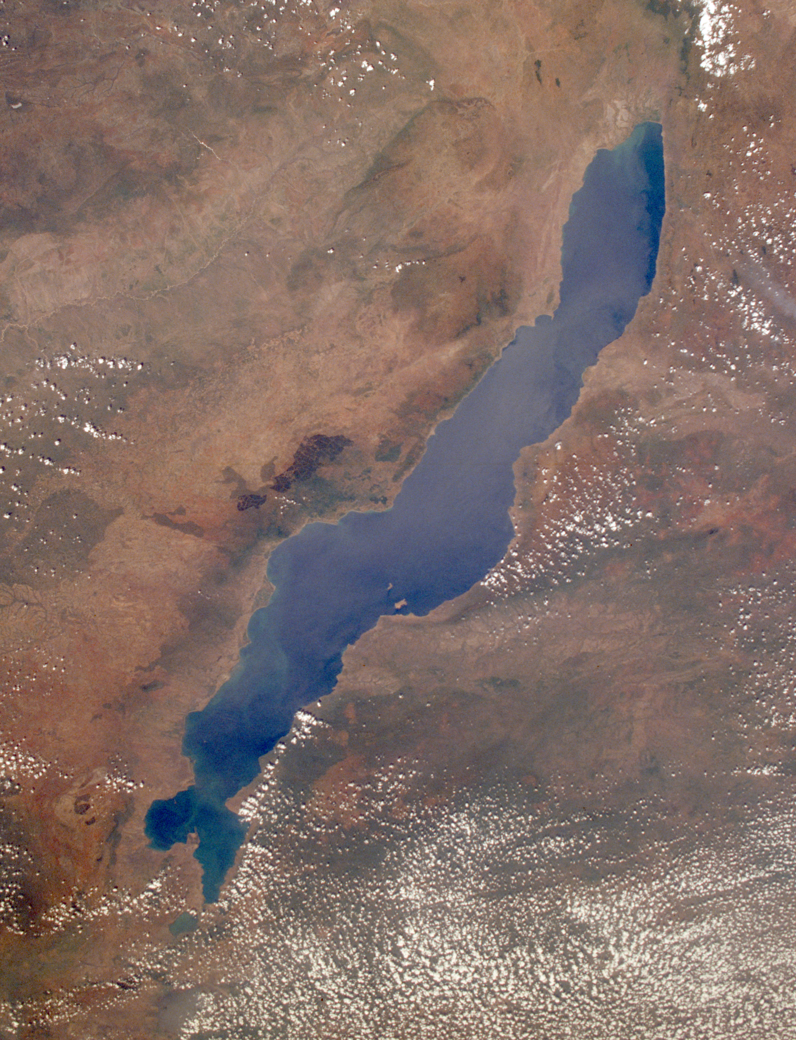
File:Lake Malawi seen from orbit.jpg
預覽大小:459 × 599 像素。 其他解析度:184 × 240 像素 | 367 × 480 像素 | 588 × 768 像素 | 784 × 1,024 像素 | 1,568 × 2,048 像素 | 2,778 × 3,628 像素。
原始檔案 (2,778 × 3,628 像素,檔案大小:3.24 MB,MIME 類型:image/jpeg)
摘要
| 描述 |
English: Leverkusen in Germany, photographed by astronauts aboard the Space Shuttle. Original image courtesy of the Image Analysis Laboratory, NASA Johnson Space Center (eol.jsc.nasa.gov). Image ID: STS061-75-48. Image cropped, sharpened and gamma-corrected.
|
| 日期 | 攝於1998年12月3日, 09:49:31 UTC |
| 來源 | https://eol.jsc.nasa.gov/SearchPhotos/photo.pl?mission=STS061&roll=75&frame=48 |
| 作者 | National Aeronautics and Space Administration (NASA) |
| 其他版本 |

本圖像或影音收錄於美國國家航空暨太空總署 (NASA)休士頓太空中心(Johnson Space Center),其照片編號為: STS061-75-48 此標籤不表示文件的著作權狀態。任何文件在附有此標籤的同時還需要一個有效的著作權標籤。請參閱許可協議說明頁面以了解更多資訊。 其他語言:
|
授權條款
This file is in the public domain in the United States because it was created by the Image Science & Analysis Laboratory, of the NASA Johnson Space Center. NASA copyright policy states that "NASA material is not protected by copyright unless noted". (NASA media use guidelines or Conditions of Use of Astronaut Photographs).
Photo source: STS061-75-48.
|
原始上傳日誌
Uploaded to en wiki by User:Worldtraveller; moved here by User:Tintazul. Full original description follows.
檔案歷史
點選日期/時間以檢視該時間的檔案版本。
| 日期/時間 | 縮圖 | 尺寸 | 使用者 | 備註 | |
|---|---|---|---|---|---|
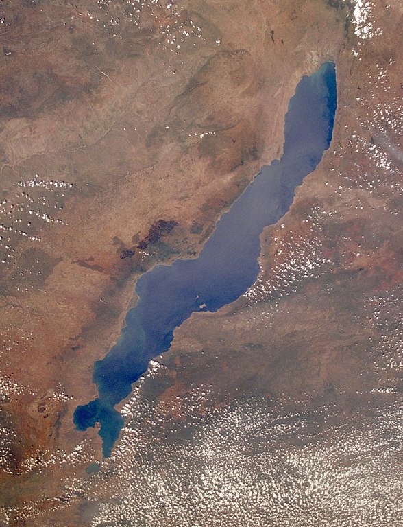
| 目前 | 2019年8月30日 (五) 19:17 | | 2,778 × 3,628(3.24 MB) | Ras67 | high resolution, cropped and rotated from NASA's original TIFF |
| 2005年11月4日 (五) 12:27 |  | 768 × 1,000(271 KB) | Tintazul | ''Uploaded to en wiki by User:Worldtraveller; moved here by User:Tintazul. Full original description follows.'' Lake Malawi in Africa, photographed by astronauts aboard the Space Shuttle. Original image courtesy of the Image Analysis Laboratory, |
檔案用途
下列67個頁面有用到此檔案:
- 似側點槳鰭麗魚
- 側點槳鰭麗魚
- 傑氏槳鰭麗魚
- 凱氏槳鰭麗魚
- 利岡槳鰭麗魚
- 利科馬島
- 博氏槳鰭麗魚
- 吉氏槳鰭麗魚
- 哈氏擬麗鱼
- 四點大咽非鯽
- 多點雨麗魚
- 小槳鰭麗魚
- 少耙擬麗魚
- 屈氏槳鰭麗魚
- 屈氏突吻麗魚
- 巴氏擬麗鱼
- 布氏大咽非鯽
- 帶斑擬麗魚
- 平行黑麗魚
- 弗氏鬼麗魚
- 扁頭恐怖麗魚
- 拟丽鱼属
- 暗色擬麗魚
- 林氏雨麗魚
- 格氏擬麗魚
- 條紋原黑麗魚
- 沃氏擬麗魚
- 洛氏槳鰭麗魚
- 淡黑鑷麗魚
- 深藍槳鰭麗魚
- 火唇柔麗鯛
- 燦擬麗魚
- 琥珀柔麗鯛
- 異鏽色擬麗魚
- 石爬大咽非鯽
- 秀擬麗魚
- 穆爾氏隆背麗鯛
- 約翰柔麗鯛
- 縱帶恐怖麗魚
- 美擬麗魚
- 背點原黑麗魚
- 胭脂擬麗鱼
- 艾利斯槳鰭麗魚
- 莫三比克擬麗魚
- 葛氏擬麗魚
- 藍頰槳鰭麗魚
- 西氏擬麗魚
- 變色擬麗魚
- 貪食擬麗魚
- 金色擬麗魚
- 金鱗擬麗魚
- 阿祖槳鰭麗魚
- 雅氏孔雀鯛
- 青頭槳鰭麗魚
- 领土
- 馬拉威湖擬麗鱼
- 馬拉威湖槳鰭麗魚
- 马拉维湖
- 魁形擬麗魚
- 黃頰擬麗魚
- 黃體擬麗魚
- 黃鰓槳鰭麗魚
- 黑丽鱼属
- 黑翼槳鰭麗魚
- 黑頭槳鰭麗魚
- 黑鰓擬麗魚
- 龍占麗魚屬
全域檔案使用狀況
以下其他 wiki 使用了這個檔案:
- af.wikipedia.org 的使用狀況
- als.wikipedia.org 的使用狀況
- ar.wikipedia.org 的使用狀況
- arz.wikipedia.org 的使用狀況
- az.wikipedia.org 的使用狀況
- ba.wikipedia.org 的使用狀況
- be-tarask.wikipedia.org 的使用狀況
- be.wikipedia.org 的使用狀況
- bg.wikipedia.org 的使用狀況
- Dimidiochromis compressiceps
- Labeotropheus trewavasae
- Labidochromis caeruleus
- Maylandia aurora
- Maylandia barlowi
- Maylandia benetos
- Maylandia callainos
- Maylandia chrysomallos
- Maylandia elegans
- Maylandia emmiltos
- Maylandia hajomaylandi
- Maylandia heteropicta
- Maylandia mbenjii
- Maylandia melabranchion
- Maylandia phaeos
- Maylandia pursa
- Maylandia pyrsonotos
- Maylandia thapsinogen
- Melanochromis parallelus
- Nimbochromis linni
- Nimbochromis polystigma
- Otopharynx brooksi
- Otopharynx lithobates
- Otopharynx tetrastigma
- Placidochromis electra
- Placidochromis johnstoni
- Placidochromis phenochilus
- Protomelas spilonotus
檢視此檔案的更多全域使用狀況。