File:Map of JAT367.png

預覽大小:640 × 600 像素。 其他解析度:256 × 240 像素 | 819 × 768 像素 | 1,092 × 1,024 像素 | 1,600 × 1,500 像素。
原始檔案 (1,600 × 1,500 像素,檔案大小:374 KB,MIME 類型:image/png)
檔案歷史
點選日期/時間以檢視該時間的檔案版本。
| 日期/時間 | 縮圖 | 尺寸 | 使用者 | 備註 | |
|---|---|---|---|---|---|
| 目前 | 2010年4月8日 (四) 16:51 | | 1,600 × 1,500(374 KB) | Karel x | Fixing altitude to 10.050 m (FL330) |
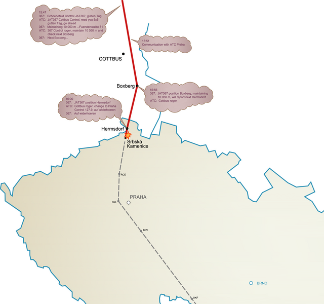
| 2009年7月20日 (一) 10:27 |  | 1,600 × 1,500(365 KB) | Karel x | {{Information |Description={{en|1=Map of flight JAT367}} |Source=Own work by uploader |Author=Karel x |Date=2009-07-20 |Permission= |other_versions= }} Category:Air disasters in 1972 [[Category:Aviation accidents in the Czech Republi |
檔案用途
下列頁面有用到此檔案:
全域檔案使用狀況
以下其他 wiki 使用了這個檔案:
- cs.wikipedia.org 的使用狀況
- de.wikipedia.org 的使用狀況
- en.wikipedia.org 的使用狀況
- fi.wikipedia.org 的使用狀況
- he.wikipedia.org 的使用狀況
- it.wikipedia.org 的使用狀況
- pt.wikipedia.org 的使用狀況
- sk.wikipedia.org 的使用狀況