File:Matewan West Virginia floodwall.jpg

預覽大小:800 × 534 像素。 其他解析度:320 × 214 像素 | 640 × 428 像素 | 1,024 × 684 像素 | 1,500 × 1,002 像素。
原始檔案 (1,500 × 1,002 像素,檔案大小:1.1 MB,MIME 類型:image/jpeg)
| 描述 |
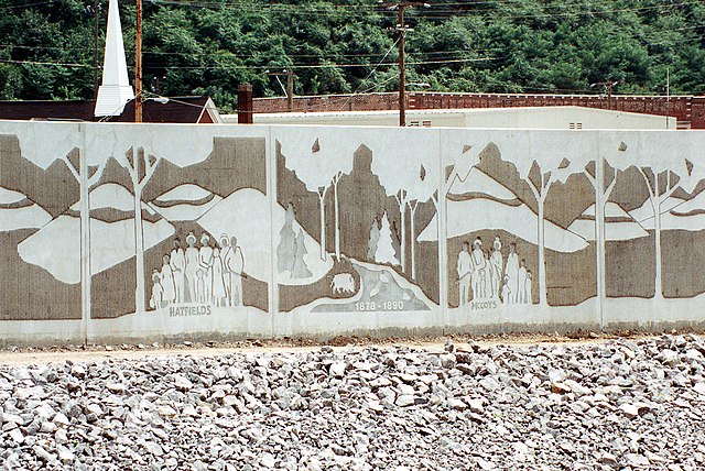
English: Close-up of a section of the floodwall along the Tug Fork River at Matewan, West Virginia, USA. The U.S. Army Corps of Engineers constructed levees and floodwalls along the river to protect the town. The wall depicts the families involved in the notorious Hatfield-McCoy feud of 1878–1891. |
|||
| 日期 | ||||
| 來源 |
U.S. Army Corps of Engineers Digital Visual Library Image page Image description page Digital Visual Library home page |
|||
| 作者 | U.S. Army Corps of Engineers, photographer not specified or unknown | |||
| 授權許可 (重用此檔案) |
|
|||
| 圖中地點 | Matewan, West Virginia, USA |
| 拍攝地點 | | 位於此地的本圖片與其他圖片: OpenStreetMap |
|---|
檔案歷史
點選日期/時間以檢視該時間的檔案版本。
| 日期/時間 | 縮圖 | 尺寸 | 使用者 | 備註 | |
|---|---|---|---|---|---|
| 目前 | 2007年3月31日 (六) 19:23 | | 1,500 × 1,002(1.1 MB) | DanMS | {{Information | Description = {{en|Close-up of a section of the floodwall along the Tug Fork River at Matewan, West Virginia, USA. The U.S. Army Corps of Engineers constructed levees and floodwalls along the river to protect the town. The wall depicts |
檔案用途
下列頁面有用到此檔案:
全域檔案使用狀況
以下其他 wiki 使用了這個檔案:
- en.wikipedia.org 的使用狀況
- es.wikipedia.org 的使用狀況
- hu.wikipedia.org 的使用狀況