File:Nubia on al-Idrisi's map (12th century).jpg
無更高解析度可提供。
Nubia_on_al-Idrisi's_map_(12th_century).jpg (453 × 577 像素,檔案大小:209 KB,MIME 類型:image/jpeg)
.jpg?uselang=zh-hant)
.jpg?uselang=zh-hant)
.jpg?action=history&uselang=zh-hant)
.jpg)
摘要
| 描述 |
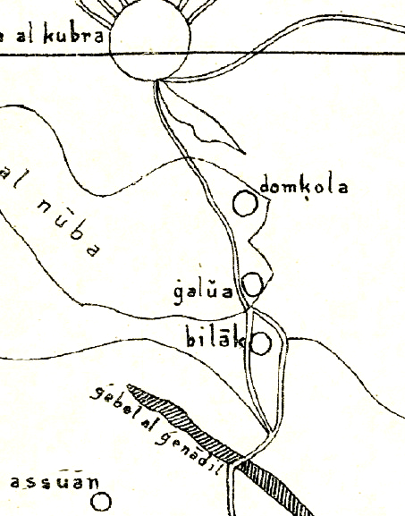
English: Nubia on al-Idrisi's small map (1192), which swaps north and south. The map contains several errors, like placing Makuria (domkola) south of Alodia (galua) or placing Philae (Bilak) in the area between the Nile and the Atbara river, although it should be located just south of Assuan. Further reading: https://journals.openedition.org/afriques/807 |
| 日期 | |
| 來源 | Die kleine Idrisikarte vom Jahr 1192 n. Chr. |
| 作者 | Konrad Miller |
授權條款
|
本作品在其來源國以及其他著作權期限是作者逝世後70年或以下的國家與地區屬於公有領域。 | |
| 此作品無已知的著作權限制,亦不受所有相關和鄰接的權利限制。 | |
檔案歷史
點選日期/時間以檢視該時間的檔案版本。
| 日期/時間 | 縮圖 | 尺寸 | 使用者 | 備註 | |
|---|---|---|---|---|---|
| 目前 | 2018年9月17日 (一) 15:07 | | 453 × 577(209 KB) | LeGabrie | User created page with UploadWizard |
檔案用途
下列頁面有用到此檔案:
全域檔案使用狀況
以下其他 wiki 使用了這個檔案:
- en.wikipedia.org 的使用狀況
- pt.wikipedia.org 的使用狀況
- vi.wikipedia.org 的使用狀況
.jpg)