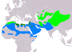
File:OenantheDesertiIUCNver2019-3.png

原始檔案 (3,507 × 2,480 像素,檔案大小:1.15 MB,MIME 類型:image/png


File:OenantheDesertiIUCN.svg是本檔案的向量版本。 如果品質不低,就應該優先使用該檔案,而非PNG檔案。

File:OenantheDesertiIUCNver2019-3.png → File:OenantheDesertiIUCN.svg

更多資訊請參閱Help:SVG/zh

其他語言
Alemannisch  العربية  беларуская (тарашкевіца)  български  বাংলা  català  нохчийн  čeština  dansk  Deutsch  Ελληνικά  English  British English  Esperanto  español  eesti  euskara  فارسی  suomi  français  Frysk  galego  Alemannisch  עברית  hrvatski  magyar  հայերեն  Bahasa Indonesia  Ido  italiano  日本語  ქართული  한국어  lietuvių  македонски  മലയാളം  Bahasa Melayu  norsk bokmål  Plattdüütsch  Nederlands  norsk nynorsk  norsk  occitan  polski  prūsiskan  português  português do Brasil  română  русский  sicilianu  Scots  slovenčina  slovenščina  српски / srpski  svenska  தமிழ்  ไทย  Türkçe  татарча / tatarça  українська  vèneto  Tiếng Việt  中文  中文(中国大陆)  中文(简体)  中文(繁體)  中文(马来西亚)  中文(新加坡)  中文(臺灣)  中文(臺灣)  +/−
新SVG圖片

摘要

描述
Slovenčina: Mapa rozšírenia druhu skaliarik púšťový Oenanthe deserti podľa IUCN verzia 2019.3:
legenda: Hniezdiaci, výskyt v letnom období (#00FF00), Hniezdiaci, celoročný výskyt (#008000), Nehniezdiaci (#007FFF)
English: Distribution map of Desert Wheatear Oenanthe deserti according to IUCN version 2019.3; key:
Legend: Extant, breeding (#00FF00), Extant, resident (#008000), Extant, non-breeding (#007FFF)
日期
來源 Made with Natural Earth. Free vetor and raster map data @ naturalearthdata.com. Range map from BirdLife International 2016. Oenanthe deserti . The IUCN Red List of Threatened Species 2016: e.T22710325A89516443. https://dx.doi.org/10.2305/IUCN.UK.2016-3.RLTS.T22710325A89516443.en. Downloaded on 12 March 2020 as visual indicator of distribution.
作者 SanoAK: Alexander Kürthy

授權條款

The use of spatial data from the IUCN Red List web site to produce species distribution maps is subject to the Attribution-Share Alike Creative Commons License. In short: you are free to distribute and modify the file as long as you attribute its authors and the IUCN Red List.

العربيَّة | English | español | français | македонски | മലയാളം | português | +/−

w:zh:創用CC
姓名標示 相同方式分享
姓名標示: IUCN Red List of Threatened Species, species assessors and the authors of the spatial data.
您可以自由:
  • 分享 – 複製、發佈和傳播本作品
  • 重新修改 – 創作演繹作品
惟需遵照下列條件:
  • 姓名標示 – 您必須指名出正確的製作者,和提供授權條款的連結,以及表示是否有對內容上做出變更。您可以用任何合理的方式來行動,但不得以任何方式表明授權條款是對您許可或是由您所使用。
  • 相同方式分享 – 若要根據本素材進行再混合、轉換或創作,則必須以與原作相同或相容的授權來發布您的作品。

說明

添加單行說明來描述出檔案所代表的內容
map of Desert Wheatear (Oenanthe deserti)

在此檔案描寫的項目

描繪內容

66fdcc219ef9fdbe2acf47cdf9a39c251d46df0a

斷定方法:​SHA-1 中文 (已轉換拼寫)

1,201,586 位元組

2,480 像素

3,507 像素

檔案歷史

點選日期/時間以檢視該時間的檔案版本。

日期/時間縮⁠圖尺寸使用者備⁠註
目前2020年3月12日 (四) 21:36於 2020年3月12日 (四) 21:36 版本的縮圖3,507 × 2,480(1.15 MB)SanoAKUploaded a work by SanoAK: Alexander Kürthy from Made with Natural Earth. Free vetor and raster map data @ naturalearthdata.com. Range map from BirdLife International 2016. Oenanthe deserti . The IUCN Red List of Threatened Species 2016: e.T22710325A89516443. https://dx.doi.org/10.2305/IUCN.UK.2016-3.RLTS.T22710325A89516443.en. Downloaded on 12 March 2020 as visual indicator of distribution. with UploadWizard

下列頁面有用到此檔案:

全域檔案使用狀況

以下其他 wiki 使用了這個檔案: