File:Roman Africa.JPG
預覽大小:752 × 600 像素。 其他解析度:301 × 240 像素 | 602 × 480 像素 | 963 × 768 像素 | 1,280 × 1,021 像素 | 2,560 × 2,042 像素 | 3,057 × 2,439 像素。
原始檔案 (3,057 × 2,439 像素,檔案大小:1.95 MB,MIME 類型:image/jpeg)
摘要
| 描述 |
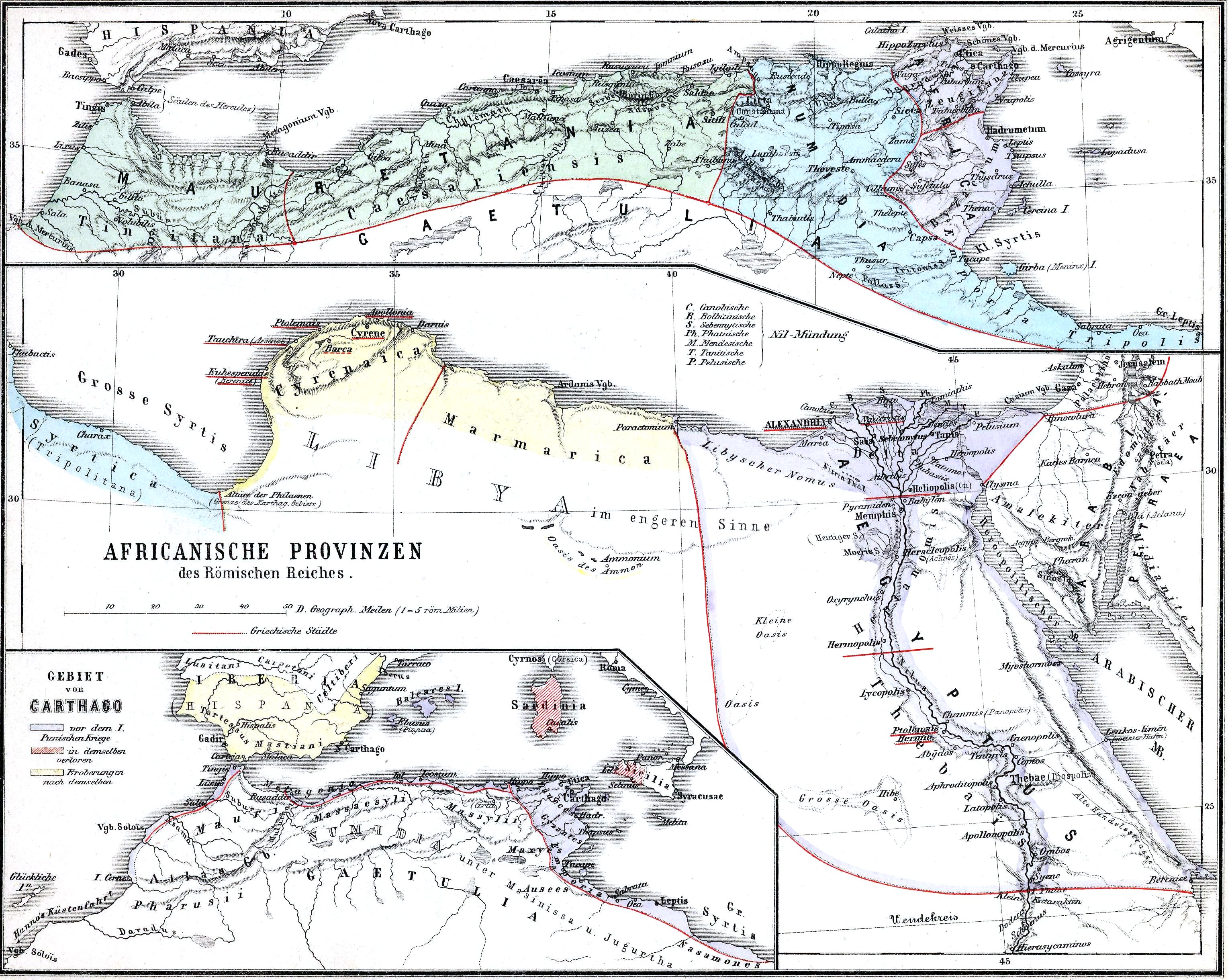
English: The African provinces of the Roman Empire. The smaller map in the lower left shows the territory of the pre-Roman state of Carthage (blue), with yellow showing conquests and hashed red indicating territory lost to Rome in the First Punic War. |
| 日期 | |
| 來源 | Historischer Schulatlas. |
| 作者 | H. Kiepert |
授權條款
|
本作品在其來源國以及其他著作權期限是作者逝世後70年或以下的國家與地區屬於公有領域。 | |
| 此作品無已知的著作權限制,亦不受所有相關和鄰接的權利限制。 | |
檔案歷史
點選日期/時間以檢視該時間的檔案版本。
| 日期/時間 | 縮圖 | 尺寸 | 使用者 | 備註 | |
|---|---|---|---|---|---|
| 目前 | 2009年11月15日 (日) 15:37 | | 3,057 × 2,439(1.95 MB) | Alex:D | whitened |
| 2009年2月14日 (六) 22:37 |  | 3,057 × 2,439(1.55 MB) | Olahus | {{Information |Description=Nothern Africa under Roman rule. |Source=Historischer Schulatlas. |Date=1879 |Author=H.Kiepert |Permission= |other_versions= }} {{PD-old}} Category:Old maps of Africa Category:Old maps of the Roman Empire [[Category:Maps |
檔案用途
下列頁面有用到此檔案:
全域檔案使用狀況
以下其他 wiki 使用了這個檔案:
- ar.wikipedia.org 的使用狀況
- arz.wikipedia.org 的使用狀況
- bg.wikipedia.org 的使用狀況
- ca.wikipedia.org 的使用狀況
- cs.wikipedia.org 的使用狀況
- de.wikipedia.org 的使用狀況
- de.wikivoyage.org 的使用狀況
- de.wiktionary.org 的使用狀況
- el.wikipedia.org 的使用狀況
- en.wikipedia.org 的使用狀況
- Numidia
- North Africa during classical antiquity
- Roman Egypt
- Byzacena
- Myos Hormos
- Tacfarinas
- List of revolutions and rebellions
- Aquae Regiae
- User:Olahus
- Uzita (Tunisia)
- El Milia
- Aggersel
- Quiza Xenitana
- Berber kings of Roman-era Tunisia
- Diocese of Maxita
- Aquae Albae in Byzacena
- Decoriana
- Simminensis (diocese)
- Zerta
- Titular Bishopric of Vita
- Elephantaria in Mauretania
- Tubia in Mauretania
- Tabuda
- Lari Castellum
- User:Ryanmhorne/pleiades List
- Ancient Africa
- eo.wikipedia.org 的使用狀況
- es.wikipedia.org 的使用狀況
- et.wikipedia.org 的使用狀況
- eu.wikipedia.org 的使用狀況
- fa.wikipedia.org 的使用狀況
- fr.wikipedia.org 的使用狀況
檢視此檔案的更多全域使用狀況。