File:Saint Anthony Falls aerial.jpg
無更高解析度可提供。
Saint_Anthony_Falls_aerial.jpg (452 × 319 像素,檔案大小:56 KB,MIME 類型:image/jpeg)
摘要
| 描述 |
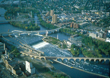
Aerial view of en:Saint Anthony Falls on the en:Mississippi River in en:Minneapolis, Minnesota. From http://www.nps.gov/parkoftheweek/photo-21.htm Image URL http://www.nps.gov/parkoftheweek/photos/miss_aerial.jpg The crossings of the river, starting from the top, are
Downtown Minneapolis is off the image to the left. A second lock and dam complex is off the image's lower right. en:Category:Images of Minneapolis, Minnesota en:Category:Images of Minnesota |
| 日期 | 2004年12月5日 (原始上傳日期) |
| 來源 | Transferred from en.wikipedia to Commons. |
| 作者 | 原上傳者為英文維基百科的Mulad |
| 目標地點 | | 位於此地的本圖片與其他圖片: OpenStreetMap |
|---|
授權條款
| This image or media file contains material based on a work of a National Park Service employee, created as part of that person's official duties. As a work of the U.S. federal government, such work is in the public domain in the United States. See the NPS website and NPS copyright policy for more information. |
原始上傳日誌
The original description page was here. All following user names refer to en.wikipedia.
- 2004-12-05 19:33 Mulad 452×319×8 (56836 bytes) Aerial view of [[Saint Anthony Falls]] in [[Minneapolis, Minnesota]]. From http://www.nps.gov/parkoftheweek/photo-21.htm Image URL http://www.nps.gov/parkoftheweek/photos/miss_aerial.jpg {{PD-USGov-NPS}}
檔案歷史
點選日期/時間以檢視該時間的檔案版本。
| 日期/時間 | 縮圖 | 尺寸 | 使用者 | 備註 | |
|---|---|---|---|---|---|
| 目前 | 2007年1月16日 (二) 01:38 | | 452 × 319(56 KB) | MECU | {{Information |Description=Aerial view of en:Saint Anthony Falls on the en:Mississippi River in en:Minneapolis, Minnesota. From http://www.nps.gov/parkoftheweek/photo-21.htm Image URL http://www.nps.gov/parkoftheweek/photos/miss_aerial.jpg |
檔案用途
下列頁面有用到此檔案:
全域檔案使用狀況
以下其他 wiki 使用了這個檔案:
- ar.wikipedia.org 的使用狀況
- ba.wikipedia.org 的使用狀況
- cs.wikipedia.org 的使用狀況
- de.wikipedia.org 的使用狀況
- en.wikipedia.org 的使用狀況
- es.wikipedia.org 的使用狀況
- fa.wikipedia.org 的使用狀況
- fr.wikipedia.org 的使用狀況
- he.wikipedia.org 的使用狀況
- hy.wikipedia.org 的使用狀況
- ja.wikipedia.org 的使用狀況
- ms.wikipedia.org 的使用狀況
- no.wikipedia.org 的使用狀況
- ru.wikipedia.org 的使用狀況
- simple.wikipedia.org 的使用狀況
- sw.wikipedia.org 的使用狀況
- ta.wikipedia.org 的使用狀況
- tt.wikipedia.org 的使用狀況
- vep.wikipedia.org 的使用狀況
- vi.wikipedia.org 的使用狀況
- www.wikidata.org 的使用狀況