File:St Joseph Michigan aerial view.jpg

預覽大小:800 × 558 像素。 其他解析度:320 × 223 像素 | 640 × 447 像素 | 1,024 × 715 像素 | 1,280 × 893 像素 | 1,500 × 1,047 像素。
原始檔案 (1,500 × 1,047 像素,檔案大小:618 KB,MIME 類型:image/jpeg)
| 描述 |
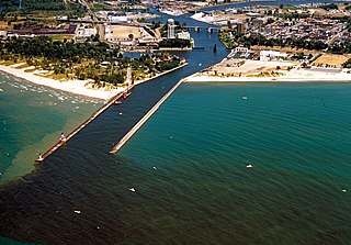
English: The shore and river outlet at St. Joseph, Michigan, USA. The St. Joseph River flows into Lake Michigan through the city of the same name. |
|||
| 日期 | not specified or unknown; predates 2000 | |||
| 來源 |
U.S. Army Corps of Engineers Digital Visual Library Image page: Archive link Image description page: Archive link Digital Visual Library home page |
|||
| 作者 | U.S. Army Corps of Engineers, photographer not specified or unknown | |||
| 授權許可 (重用此檔案) |
|
|||
| 圖中地點 | St. Joseph, Berrien County, Michigan, USA |
| 拍攝地點 | | 位於此地的本圖片與其他圖片: OpenStreetMap |
|---|


檔案歷史
點選日期/時間以檢視該時間的檔案版本。
| 日期/時間 | 縮圖 | 尺寸 | 使用者 | 備註 | |
|---|---|---|---|---|---|
| 目前 | 2007年3月30日 (五) 03:14 | | 1,500 × 1,047(618 KB) | DanMS | {{Information | Description = {{en|The shore and river outlet at St. Joseph, Michigan, USA. The St. Joseph River flows into Lake Michigan through the city of the same name.}} | Source = U.S. Army Corps of Engineers Digital Visual Library<br />[ |
檔案用途
下列2個頁面有用到此檔案:
全域檔案使用狀況
以下其他 wiki 使用了這個檔案:
- ar.wikipedia.org 的使用狀況
- arz.wikipedia.org 的使用狀況
- ceb.wikipedia.org 的使用狀況
- ce.wikipedia.org 的使用狀況
- cy.wikipedia.org 的使用狀況
- dag.wikipedia.org 的使用狀況
- de.wikipedia.org 的使用狀況
- en.wikipedia.org 的使用狀況
- en.wikivoyage.org 的使用狀況
- es.wikipedia.org 的使用狀況
- eu.wikipedia.org 的使用狀況
- fr.wikipedia.org 的使用狀況
- hu.wikipedia.org 的使用狀況
- it.wikipedia.org 的使用狀況
- lld.wikipedia.org 的使用狀況
- pl.wikipedia.org 的使用狀況
- pt.wikipedia.org 的使用狀況
- ro.wikipedia.org 的使用狀況
- ru.wikipedia.org 的使用狀況
- sr.wikipedia.org 的使用狀況
- sv.wikipedia.org 的使用狀況
- tt.wikipedia.org 的使用狀況
- uk.wikipedia.org 的使用狀況
- uz.wikipedia.org 的使用狀況
- www.wikidata.org 的使用狀況
- zh-min-nan.wikipedia.org 的使用狀況