File:Volcanic zones of Iceland.svg

此 SVG 檔案的 PNG 預覽的大小:726 × 550 像素。 其他解析度:317 × 240 像素 | 634 × 480 像素 | 1,014 × 768 像素 | 1,280 × 970 像素 | 2,560 × 1,939 像素。
原始檔案 (SVG 檔案,表面大小:726 × 550 像素,檔案大小:162 KB)
摘要
| 描述 |
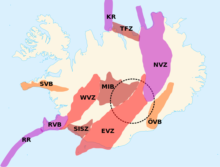
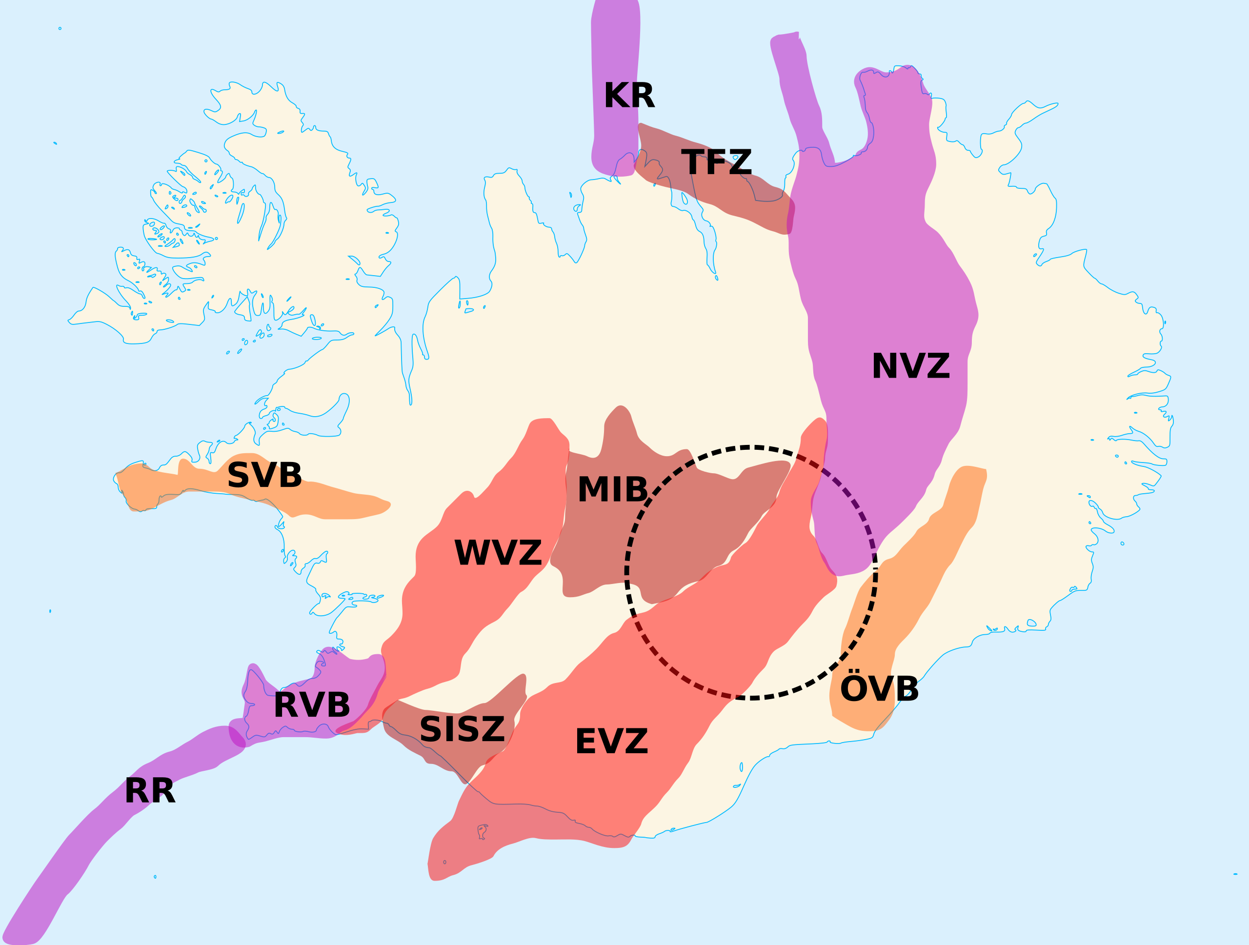
English: Delimitations of the eleven volcanic zones of Iceland. The dotted circle is the position of the hypothetical Iceland hotspot. Français : Délimitations des onze zones volcaniques d’Islande. Le cercle pointillé indique la position de l’hypothétique point chaud d’Islande. KR:Kolbeinsey Ridge。
NVZ:North Volcanic Zone。
RR:Reykjanes Ridge。
MIB:Mid-Iceland Belt。
WVZ:West Volcanic Zone。
EVZ:East Volcanic Zone。
ÖVB:Öræfi Volcanic Belt。 |
| 日期 | |
| 來源 | Own work made with inkscape from Image:Blank map of Iceland.svg and [1] |
| 作者 | Lanredec |
授權條款
我,本作品的著作權持有者,決定用以下授權條款發佈本作品:
此檔案採用創用CC 姓名標示-相同方式分享 3.0 未在地化版本授權條款。
- 您可以自由:
- 分享 – 複製、發佈和傳播本作品
- 重新修改 – 創作演繹作品
- 惟需遵照下列條件:
- 姓名標示 – 您必須指名出正確的製作者,和提供授權條款的連結,以及表示是否有對內容上做出變更。您可以用任何合理的方式來行動,但不得以任何方式表明授權條款是對您許可或是由您所使用。
- 相同方式分享 – 如果您利用本素材進行再混合、轉換或創作,您必須基於如同原先的相同或兼容的條款,來分布您的貢獻成品。
檔案歷史
點選日期/時間以檢視該時間的檔案版本。
| 日期/時間 | 縮圖 | 尺寸 | 使用者 | 備註 | |
|---|---|---|---|---|---|
| 目前 | 2011年10月8日 (六) 11:09 | | 726 × 550(162 KB) | Ciaurlec | Filled areas, differenciated colours according to type of zone |
| 2011年6月18日 (六) 10:40 |  | 726 × 550(201 KB) | Lanredec |
檔案用途
下列頁面有用到此檔案:
全域檔案使用狀況
以下其他 wiki 使用了這個檔案:
- da.wikipedia.org 的使用狀況
- en.wikipedia.org 的使用狀況
- es.wikipedia.org 的使用狀況
- fr.wikipedia.org 的使用狀況
- Torfajökull
- Parc national du Vatnajökull
- Point chaud d'Islande
- Région volcanique d'Islande
- Ceinture volcanique de Reykjanes
- Zone de fracture de Tjörnes
- Zone volcanique Ouest
- Ceinture médio-islandaise
- Zone volcanique Est
- Zone volcanique Nord
- Ceinture volcanique d'Öræfi
- Ceinture volcanique de Snæfellsnes
- hu.wikipedia.org 的使用狀況
- id.wikipedia.org 的使用狀況
- pl.wikipedia.org 的使用狀況
- pt.wikipedia.org 的使用狀況