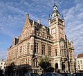
File:Borgerhout Gemeentehuis2.JPG

預覽大小:655 × 600 像素。 其他解析度:262 × 240 像素 | 524 × 480 像素 | 839 × 768 像素 | 1,119 × 1,024 像素 | 2,238 × 2,048 像素 | 2,986 × 2,733 像素。
原始檔案 (2,986 × 2,733 像素,檔案大小:1.72 MB,MIME 類型:image/jpeg)
檔案歷史
點選日期/時間以檢視該時間的檔案版本。
| 日期/時間 | 縮圖 | 尺寸 | 用戶 | 備註 | |
|---|---|---|---|---|---|
| 目前 | 2011年1月8日 (六) 22:50 |  | 2,986 × 2,733(1.72 MB) | Maurilbert | Perspective corrected, slight denoising, using GIMP. |
| 2009年7月17日 (五) 19:59 |  | 2,986 × 2,733(1.56 MB) | Torsade de Pointes | {{Information |Description={{nl|1=Antwerpen, distr. Borgerhout. Neo-renaissance districtshuis (ex-gemeentehuis), gebouwd 1886-1889, n.o.v. arch. Blomme. }} {{fr|1=Anvers, Belgique. Maison de district (anciennement maison communale, =mairie) de Borgerhout. |
檔案用途
下列頁面有用到此檔案:
全域檔案使用狀況
以下其他 wiki 使用了這個檔案:
- ca.wikipedia.org 的使用狀況
- en.wikipedia.org 的使用狀況
- eo.wikipedia.org 的使用狀況
- fr.wikipedia.org 的使用狀況
- nl.wikipedia.org 的使用狀況
- ru.wikipedia.org 的使用狀況
- tr.wikipedia.org 的使用狀況
- www.wikidata.org 的使用狀況
