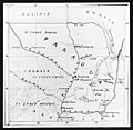
File:Cosme.jpg

預覽大小:615 × 599 像素。 其他解析度:246 × 240 像素 | 493 × 480 像素 | 788 × 768 像素 | 1,051 × 1,024 像素 | 2,102 × 2,048 像素 | 2,648 × 2,580 像素。
原始檔案 (2,648 × 2,580 像素,檔案大小:1.22 MB,MIME 類型:image/jpeg)
檔案歷史
點選日期/時間以檢視該時間的檔案版本。
| 日期/時間 | 縮圖 | 尺寸 | 用戶 | 備註 | |
|---|---|---|---|---|---|
| 目前 | 2006年7月28日 (五) 05:14 |  | 2,648 × 2,580(1.22 MB) | Moondyne | {{Information |Description= Map of Paraguay, drawn by hand by John Lane (brother of William Lane). New Australia Colony and Cosme Colony were south-west of Asunción, the capital of Paraguay, close to the town of Villarica. |Source=http://hdl.handle.net/2 |
檔案用途
下列頁面有用到此檔案:
全域檔案使用狀況
以下其他 wiki 使用了這個檔案:
- de.wikipedia.org 的使用狀況
- en.wikipedia.org 的使用狀況
- es.wikipedia.org 的使用狀況
- hy.wikipedia.org 的使用狀況
- it.wikipedia.org 的使用狀況
- ka.wikipedia.org 的使用狀況
- www.wikidata.org 的使用狀況
