File:Dead trees at Mammoth Hot Springs.jpg
預覽大小:800 × 529 像素。 其他解析度:320 × 212 像素 | 640 × 423 像素 | 1,024 × 677 像素 | 1,280 × 846 像素 | 2,400 × 1,587 像素。
原始檔案 (2,400 × 1,587 像素,檔案大小:2.9 MB,MIME 類型:image/jpeg)
|
摘要
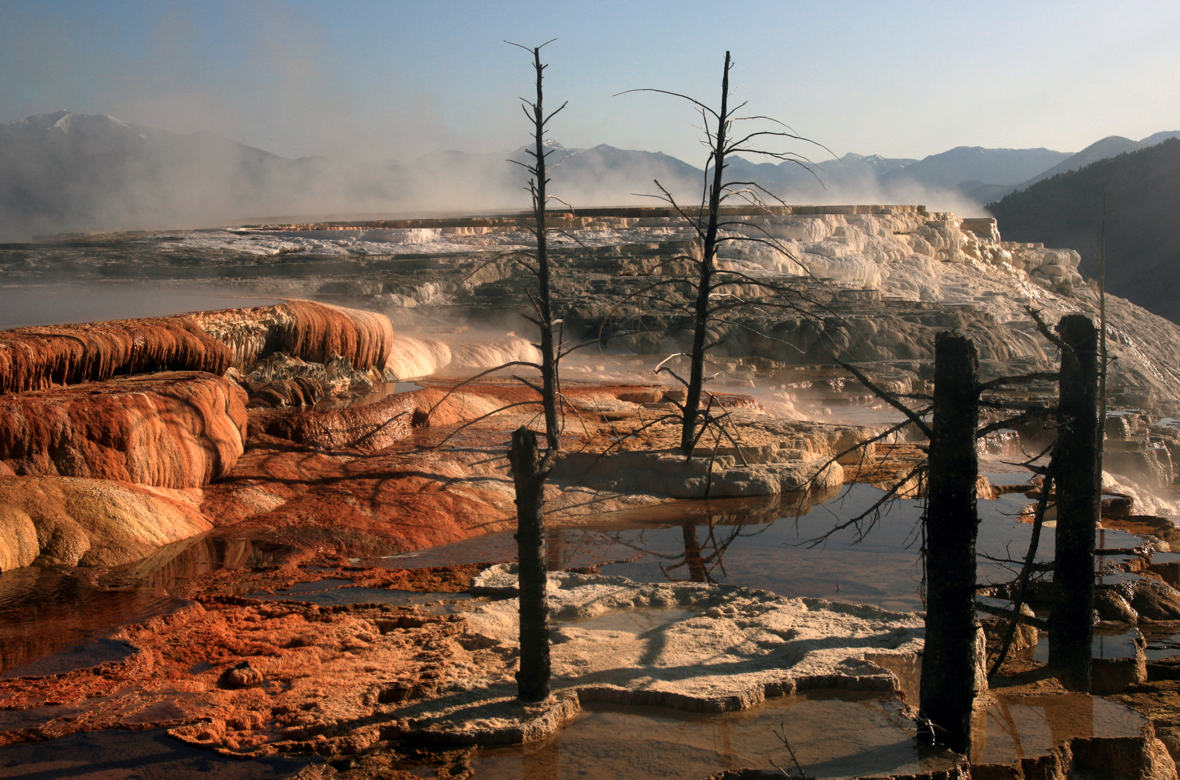
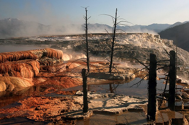
| 描述 | Mammoth Hot Springs terraces. Hot water is the creative force of the terraces.Even though Mammoth Hot Springs lie north of the caldera ring-fracture system, a fault trending north from Norris Geyser Basin, 21 miles (34 km) away, may connect Mammoth Hot Springs to the hot water of that system. A system of small fissures carries water upward to create approximately 50 hot springs in the Mammoth Hot Springs area. Another necessary ingredient for terrace growth is the mineral calcium carbonate. Thick layers of sedimentary limestone, deposited millions of years ago by vast seas, lie beneath the Mammoth area. As ground water seeps slowly downward and laterally, it comes in contact with hot gases charged with carbon dioxide rising from the magma chamber. Some carbon dioxide is readily dissolved in the hot water to form a weak carbonic acid solution. This hot, acidic solution dissolves great quantities of limestone as it works up through the rock layers to the surface hot springs. Once exposed to the open air, some of the carbon dioxide escapes from solution. As this happens, limestone can no longer remain in solution. A solid mineral reforms and is deposited as the travertine that forms the terraces.Dead trees in the terraces of Mammoth Hot Springs, Yellowstone National Park grew during inactivity of the mineral-rich springs, and were killed when calcium carbonate carried by spring water clogged the vascular systems of the trees. |
| 日期 | |
| 來源 | 自己的作品 |
| 作者 | Brocken Inaglory |
| 拍攝地點 | | 位於此地的本圖片與其他圖片: OpenStreetMap |
|---|
授權條款
我,本作品的著作權持有者,決定用以下授權條款發佈本作品:
此檔案採用共享創意 姓名標示-相同方式分享 3.0 未在地化版本授權條款。
- 您可以自由:
- 分享 – 複製、發佈和傳播本作品
- 重新修改 – 創作演繹作品
- 惟需遵照下列條件:
- 姓名標示 – 您必須指名出正確的製作者,和提供授權條款的連結,以及表示是否有對內容上做出變更。您可以用任何合理的方式來行動,但不得以任何方式表明授權條款是對您許可或是由您所使用。
- 相同方式分享 – 如果您利用本素材進行再混合、轉換或創作,您必須基於如同原先的相同或兼容的條款,來分布您的貢獻成品。

|
已授權您依據自由軟體基金會發行的無固定段落、封面文字和封底文字GNU自由文件授權條款1.2版或任意後續版本,對本檔進行複製、傳播和/或修改。該協議的副本列在GNU自由文件授權條款中。 |
您可以選擇您需要的授權條款。
檔案歷史
點選日期/時間以檢視該時間的檔案版本。
| 日期/時間 | 縮圖 | 尺寸 | 用戶 | 備註 | |
|---|---|---|---|---|---|
| 目前 | 2008年6月27日 (五) 23:10 | | 2,400 × 1,587(2.9 MB) | Mbz1 | {{Information |Description={{en|1=m}} |Source=Own work by uploader |Author=Mbz1 |Date= |Permission= |other_versions= }} {{ImageUpload|full}} |
檔案用途
下列12個頁面有用到此檔案:
全域檔案使用狀況
以下其他 wiki 使用了這個檔案:
- ca.wikipedia.org 的使用狀況
- da.wikipedia.org 的使用狀況
- de.wikipedia.org 的使用狀況
- en.wikipedia.org 的使用狀況
- Geothermal areas of Yellowstone
- Mammoth Hot Springs
- List of Yellowstone geothermal features
- Wikipedia:Featured pictures/Places/Landscapes
- Wikipedia:WikiProject Wyoming
- Wikipedia:Featured pictures thumbs/22
- Wikipedia:WikiProject Volcanoes/Content
- User talk:Mbz1/a7
- Wikipedia:Featured picture candidates/February-2010
- Wikipedia:Featured picture candidates/Mammoth Hot Springs at Yellowstone National Park
- Wikipedia:Wikipedia Signpost/2010-02-15/Features and admins
- Wikipedia:WikiProject United States/Recognized content
- User talk:Mbz1/Archive 30
- Wikipedia:WikiProject United States/Quality content
- User talk:Mbz1/a77
- Talk:Mammoth Hot Springs
- Wikipedia:WikiProject Wyoming/Featured content
- Wikipedia:Picture of the day/September 2011
- Template:POTD/2011-09-15
- Wikipedia:Main Page history/2011 September 15
- User:Gowtham shiva
- Wikipedia:Wikipedia Signpost/Single/2010-02-15
- Wikipedia:WikiProject United States/Featured pictures
- User:Conceptyphoon/sandbox
- en.wikivoyage.org 的使用狀況
- es.wikipedia.org 的使用狀況
- Geografía de Estados Unidos
- Wikipedia:Recurso del día/julio de 2008
- Wikipedia:Candidatos a recursos destacados/Julio-2008
- Wikipedia:Candidatos a recursos destacados/Dead trees at Mammoth Hot Springs.jpg
- Plantilla:RDD/206
- Wikipedia:Recurso del día/201 - 300
- Wikipedia:Recurso del día/abril de 2009
- Anexo:Patrimonio de la Humanidad en Estados Unidos
- Wikipedia:Recurso del día/julio de 2010
- Wikipedia:Recurso del día/enero de 2012
- Wikipedia:Recurso del día/enero de 2014
- Wikipedia:Recurso del día/julio de 2016
- Wikipedia:Recurso del día/octubre de 2018
- Wikipedia:Recurso del día/febrero de 2021
- Wikipedia:Recurso del día/enero de 2024
- fa.wikipedia.org 的使用狀況
- fr.wikipedia.org 的使用狀況
- hu.wikipedia.org 的使用狀況
- ko.wikipedia.org 的使用狀況
檢視此檔案的更多全域使用狀況。