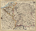
File:F. Müllhaupt's Militarische & Verkehrs-Karte der Deutsch-Französischen Grenze...jpg

預覽大小:700 × 599 像素。 其他解析度:280 × 240 像素 | 561 × 480 像素 | 897 × 768 像素 | 1,196 × 1,024 像素 | 2,392 × 2,048 像素 | 8,150 × 6,978 像素。
原始檔案 (8,150 × 6,978 像素,檔案大小:75.1 MB,MIME 類型:image/jpeg)
檔案歷史
點選日期/時間以檢視該時間的檔案版本。
| 日期/時間 | 縮圖 | 尺寸 | 用戶 | 備註 | |
|---|---|---|---|---|---|
| 目前 | 2013年4月4日 (四) 13:02 |  | 8,150 × 6,978(75.1 MB) | ComputerHotline | {{LargeImage}} {{Information |Description= Titre : F. Müllhaupt's Militarische & Verkehrs-Karte der Deutsch-Französischen Grenze.... Carte militaire et commerciale des frontières franco-allemandes ainsi que des Etats limitrophes de la Belgique, de l... |
檔案用途
下列2個頁面有用到此檔案:
全域檔案使用狀況
以下其他 wiki 使用了這個檔案:
- be-tarask.wikipedia.org 的使用狀況
- bn.wikipedia.org 的使用狀況
- crh.wikipedia.org 的使用狀況
- cv.wikipedia.org 的使用狀況
- hu.wikipedia.org 的使用狀況
- ka.wikipedia.org 的使用狀況
- ko.wikipedia.org 的使用狀況
- krc.wikipedia.org 的使用狀況
- lbe.wikipedia.org 的使用狀況
- nl.wikipedia.org 的使用狀況
- os.wikipedia.org 的使用狀況
- pt.wikipedia.org 的使用狀況
- ru.wikipedia.org 的使用狀況
- ru.wikinews.org 的使用狀況
- sah.wikipedia.org 的使用狀況
- sq.wikipedia.org 的使用狀況
- uk.wikipedia.org 的使用狀況
- vi.wikipedia.org 的使用狀況
- xal.wikipedia.org 的使用狀況

