File:Freedom of Panorama in Europe.svg

原始檔案 (SVG 檔案,表面大小:828 × 696 像素,檔案大小:700 KB)


Any autoconfirmed user can overwrite this file from the same source. Please ensure that overwrites comply with the guideline.

摘要

描述
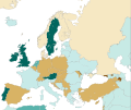
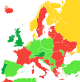
Deutsch: Übersichtskarte über den Geltungsbereich der Panoramafreiheit in den Ländern Europas (aus dem für Wikimedia Commons relevanten Standpunkt).
English: A map showing the level of Freedom of Panorama (as seen from the Wikimedia Commons standpoint) in the countries of Europe as well as parts of Western Asia and North Africa
Español: Mapa que ilustra las categorías de la libertad de panorama (desde la perpectiva de Wikimedia Commons) en los países europeos.
Français : Carte montrant le niveau liberté de Panorama (du point de vue de Wikimedia Commons) dans les pays d'Europe.
Italiano: Mappa che illustra la situazione della c.d. libertà di panorama (dal punto di vista di Wikimedia Commons) nei Paesi europei.
日本語: ヨーロッパ諸国の風景の自由 (英語版) (ウィキメディア・コモンズの見解による) の程度。
Nederlands: Kaart tonende het niveau van de panoramavrijheid (vanuit het Wikimedia Commons oogpunt) van de Europese landen.
Tagalog: Isang mapa na nagpapakita ng mga antas ng kalayaan sa panorama (sang-ayon sa pananaw ng Wikimedia Commons) sa mga bansang Europeo.
中文:一張地圖,顯示了歐洲國家的全景自由(從維基共享資源的角度來看)。
 
NL: Public interiors are OK, but schools, opera buildings, entrance halls of businesses, and museums are not public places for the purpose of Dutch law, while railway stations are.
 
OK, including public interiors
 
OK
 
OK for buildings only
 
Not OK (Note: this is from the Wikimedia Commons standpoint, so includes countries with non-commercial FOP)
 
Inconclusive or unknown (only Andorra, San Marino, Monaco, Crimea, and Sweden are marked as "Inconclusive or unknown")
日期 / 2010年4月20日, 16:49 (UTC) (原始上傳日期)
來源 本檔案衍生自: Blank map of Europe cropped.svg
作者
其他版本
SVG開發
InfoField
 
SVG檔案的原始碼通過W3C驗證
 
向量圖形使用Inkscape創作。

授權條款

我,本作品的著作權持有者,決定用以下授權條款發佈本作品:
w:zh:共享創意
姓名標示 相同方式分享
您可以自由:
  • 分享 – 複製、發佈和傳播本作品
  • 重新修改 – 創作演繹作品
惟需遵照下列條件:
  • 姓名標示 – 您必須指名出正確的製作者,和提供授權條款的連結,以及表示是否有對內容上做出變更。您可以用任何合理的方式來行動,但不得以任何方式表明授權條款是對您許可或是由您所使用。
  • 相同方式分享 – 若要根據本素材進行再混合、轉換或創作,則必須以與原作相同或相容的授權來發布您的作品。

原始上傳日誌

This image is a derivative work of the following images:

  • File:Blank map of Europe cropped.svg licensed with Cc-by-sa-2.5
    • 2010-04-20T15:38:55Z Quibik 645x690 (266750 Bytes) Serbia had a wrong ISO code.
    • 2010-04-20T14:50:17Z Quibik 645x690 (266733 Bytes) RSVG's rendering failed, trying to fix
    • 2010-04-20T14:45:48Z Quibik 645x690 (264475 Bytes) further cleanup
    • 2009-04-30T19:51:36Z Insuranze 645x690 (269667 Bytes) code cleanup
    • 2007-06-07T22:58:16Z Revolus 645x690 (540660 Bytes) {{Information | Description=Cropped version of [[:Image:Blank map of Europe.svg|Blank map of Europe.svg]] as descriped by its author. {{en|A blank Map of Europe in SVG format. Every country has an id which is its ISO-3116-1-

Uploaded with derivativeFX

說明

添加單行說明來描述出檔案所代表的內容

在此檔案描寫的項目

描繪內容

全景自由 繁體中文 (已轉換拼寫)

在圖片中識別者 繁體中文 (已轉換拼寫):​country

著作權狀態 繁體中文 (已轉換拼寫)

有著作權 繁體中文 (已轉換拼寫)

多媒體型式 繁體中文 (已轉換拼寫)

image/svg+xml

檔案歷史

點選日期/時間以檢視該時間的檔案版本。

最新 | 最早) 檢視(較新 10 筆 | )(10 | 20 | 50 | 100 | 250 | 500
日期/時間縮⁠圖尺寸用戶備⁠註
目前2024年5月4日 (六) 18:45於 2024年5月4日 (六) 18:45 版本的縮圖828 × 696(700 KB)ToprakMupdated Northern Cyprus
2023年10月21日 (六) 15:51於 2023年10月21日 (六) 15:51 版本的縮圖828 × 696(700 KB)Goldenupdate Artsakh
2023年2月13日 (一) 17:15於 2023年2月13日 (一) 17:15 版本的縮圖828 × 696(704 KB)TilmannRReverted to previous version. Major changes should be discussed and more carefully planned.
2023年2月13日 (一) 15:28於 2023年2月13日 (一) 15:28 版本的縮圖828 × 696(716 KB)Amitchell125colours replaced to suit people who are colour-blind
2022年4月17日 (日) 15:38於 2022年4月17日 (日) 15:38 版本的縮圖828 × 696(704 KB)SaippuakauppiasCrimea grey, cf. Discussion
2021年10月26日 (二) 10:12於 2021年10月26日 (二) 10:12 版本的縮圖828 × 696(704 KB)BrateevskySmaller map with Kazakhstan and Caucasus states
2021年10月26日 (二) 06:44於 2021年10月26日 (二) 06:44 版本的縮圖1,078 × 697(704 KB)BrateevskyReverted to version as of 07:03, 4 September 2021 (UTC): Kazakhstan and Azerbaijan are European countries
2021年10月9日 (六) 09:40於 2021年10月9日 (六) 09:40 版本的縮圖593 × 606(704 KB)Chubit...
2021年9月4日 (六) 07:03於 2021年9月4日 (六) 07:03 版本的縮圖1,078 × 697(704 KB)ChubitAlgeria and Tunisia to grass green
2021年8月25日 (三) 05:02於 2021年8月25日 (三) 05:02 版本的縮圖593 × 606(704 KB)ChubitAdjust the border
最新 | 最早) 檢視(較新 10 筆 | )(10 | 20 | 50 | 100 | 250 | 500

下列頁面有用到此檔案:

全域檔案使用狀況

以下其他 wiki 使用了這個檔案:

檢視此檔案的更多全域使用狀況

詮釋資料