File:Ganganagar district map.jpg

預覽大小:737 × 600 像素。 其他解析度:295 × 240 像素 | 590 × 480 像素 | 944 × 768 像素 | 1,024 × 833 像素。
原始檔案 (1,024 × 833 像素,檔案大小:175 KB,MIME 類型:image/jpeg)
摘要
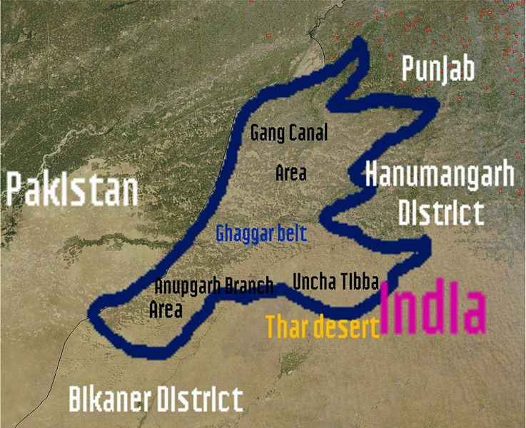
| 描述 | I (wikiuser:Shemaroo aka Shivender Singh)have uploaded this photo and created by Nasa and this photo is in Public domain.In this photo you can see satellite image of Ganganagar district.Email:Sivendersingh@gmail.comShemaroo (talk) 07:25, 27 February 2012 (UTC) |
| 來源 | |
| 作者 | See below |


授權條款
| 本作品由NASA創作,屬於公有領域。根據NASA的版權政策:“NASA的創作除非另有聲明否則不受版權保護。”(參見:Template:PD-USGov/zh,NASA版權政策或JPL圖像使用政策) | ||
 |
警告:
|
原始上傳日誌
The original description page was here. All following user names refer to en.wikipedia.
| 日期/時間 | 尺寸 | 用戶 | 備註 |
|---|---|---|---|
| 2012-02-27 07:25:31 | 1024× 833× | Shemaroo | I (wikiuser:Shemaroo aka Shivender Singh)have uploaded this photo and created by Nasa and this photo is in Public domain.In this photo you can see map of Ganganagar district.~~~~ |
檔案歷史
點選日期/時間以檢視該時間的檔案版本。
| 日期/時間 | 縮圖 | 尺寸 | 用戶 | 備註 | |
|---|---|---|---|---|---|
| 目前 | 2016年11月5日 (六) 20:23 | | 1,024 × 833(175 KB) | Zppix | Transferred from en.wikipedia (MTC!) |
檔案用途
下列頁面有用到此檔案:
全域檔案使用狀況
以下其他 wiki 使用了這個檔案:
- en.wikipedia.org 的使用狀況