File:Geo Map of Median Income by Location in Tennessee.png

預覽大小:800 × 406 像素。 其他解析度:320 × 162 像素 | 640 × 325 像素 | 1,024 × 520 像素 | 1,738 × 882 像素。
原始檔案 (1,738 × 882 像素,檔案大小:603 KB,MIME 類型:image/png)
摘要
| 描述 |
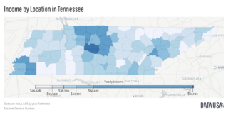
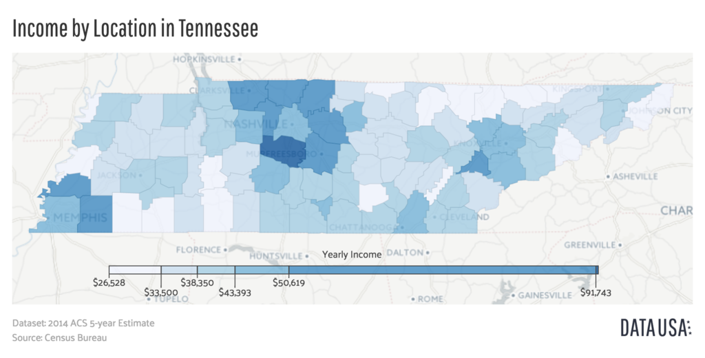
English: A geomap showing the counties of Tennessee colored by the relative range of that county's median income. Data is sourced from the 2014 ACS 5-year Estimate Report put out by the US Census Bureau |
| 日期 | |
| 來源 | http://datausa.io/profile/geo/tennessee/#income_geo |
| 作者 | Datawheel, LLC |
授權條款

|
This work is free software; you can redistribute it and/or modify it under the terms of the GNU Affero General Public License as published by the Free Software Foundation; either version 3 of the License, or any later version. This work is distributed in the hope that it will be useful, but without any warranty; without even the implied warranty of merchantability or fitness for a particular purpose. See version 3 of the GNU Affero General Public License for more details.
|
檔案歷史
點選日期/時間以檢視該時間的檔案版本。
| 日期/時間 | 縮圖 | 尺寸 | 用戶 | 備註 | |
|---|---|---|---|---|---|
| 目前 | 2016年8月3日 (三) 20:31 | | 1,738 × 882(603 KB) | Mattrdini | User created page with UploadWizard |
檔案用途
下列頁面有用到此檔案:
全域檔案使用狀況
以下其他 wiki 使用了這個檔案:
- en.wikipedia.org 的使用狀況
- fa.wikipedia.org 的使用狀況
- ru.wikipedia.org 的使用狀況
- vi.wikipedia.org 的使用狀況