File:Gonu 2007-06-04 0900Z.jpg

預覽大小:450 × 600 像素。 其他解析度:180 × 240 像素 | 360 × 480 像素 | 576 × 768 像素 | 768 × 1,024 像素 | 1,536 × 2,048 像素 | 5,550 × 7,400 像素。
原始檔案 (5,550 × 7,400 像素,檔案大小:9.84 MB,MIME 類型:image/jpeg)
摘要
| 描述 |
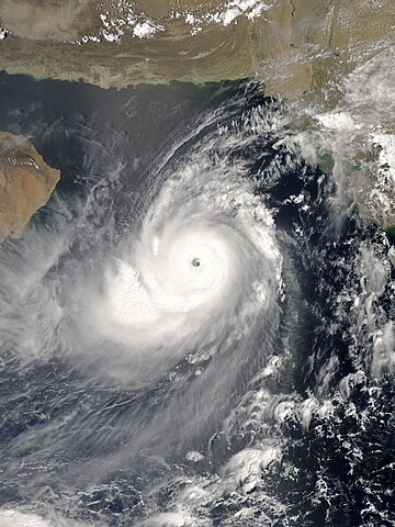
English: The Aqua satellite acquired the picture of Gonu, the most intense tropical cyclone of the Arabian Sea on record, at 12:00 Arabia Standard Time (09:00 UTC) on 4 June 2007. Although the India Meteorological Department claimed that Gonu intensified into a super cyclonic storm at 15:00 UTC, the Joint Typhoon Warning Center indicated that Gonu had started to weaken since 12:00 UTC. Based on the appearance, the picture should be at peak intensity in reality. |
| 日期 | |
| 來源 | NASA Earth Observatory |
| 作者 | MODIS image captured by NASA’s Aqua satellite |
| 拍攝地點 | | 位於此地的本圖片與其他圖片: OpenStreetMap |
|---|
授權條款
| 本作品由NASA創作,屬於公有領域。根據NASA的版權政策:“NASA的創作除非另有聲明否則不受版權保護。”(參見:Template:PD-USGov/zh,NASA版權政策或JPL圖像使用政策) | ||
 |
警告:
|
檔案歷史
點選日期/時間以檢視該時間的檔案版本。
| 日期/時間 | 縮圖 | 尺寸 | 用戶 | 備註 | |
|---|---|---|---|---|---|
| 目前 | 2016年10月27日 (四) 10:05 | | 5,550 × 7,400(9.84 MB) | Meow | Optimised from the original TIFF file under current standards. |
| 2007年11月15日 (四) 04:55 |  | 6,000 × 7,800(7.7 MB) | Good kitty | == Summary == {{Information |Description=You might expect to see a storm with near-perfect symmetry and a well-defined eye hoovering over the warm waters of the Caribbean or in the South Pacific, but Tropical Cyclone Gonu showed up in an unusual place. On |
檔案用途
下列13個頁面有用到此檔案:
全域檔案使用狀況
以下其他 wiki 使用了這個檔案:
- bn.wikipedia.org 的使用狀況
- de.wikipedia.org 的使用狀況
- en.wikipedia.org 的使用狀況
- Cyclone
- North Indian Ocean tropical cyclone
- Portal:Tropical cyclones
- 2007 North Indian Ocean cyclone season
- Portal:Tropical cyclones/Anniversaries/June
- Portal:Tropical cyclones/Anniversaries/June/4
- Cyclone Gonu
- List of the most intense tropical cyclones
- Wikipedia:Today's featured article/June 3, 2010
- Wikipedia:Today's featured article/June 2010
- Tropical cyclones in 2007
- Portal:Iran/Selected article/5
- Wikipedia:Featured picture candidates/June-2013
- Wikipedia:Featured picture candidates/Super Cyclonic Storm Gonu
- List of Arabian Peninsula tropical cyclones
- Wikipedia:Today's featured list/September 2019
- Wikipedia:Today's featured list/September 6, 2019
- Wikipedia:Main Page history/2019 September 6
- es.wikipedia.org 的使用狀況
- fa.wikipedia.org 的使用狀況
- fr.wikipedia.org 的使用狀況
- id.wikipedia.org 的使用狀況
- ko.wikipedia.org 的使用狀況
- nl.wikipedia.org 的使用狀況
- pt.wikipedia.org 的使用狀況
- uk.wikipedia.org 的使用狀況
- vi.wikipedia.org 的使用狀況