File:Isle of Jersey (ASTER).jpg

預覽大小:763 × 600 像素。 其他解析度:306 × 240 像素 | 611 × 480 像素 | 978 × 768 像素 | 1,280 × 1,006 像素 | 1,400 × 1,100 像素。
原始檔案 (1,400 × 1,100 像素,檔案大小:231 KB,MIME 類型:image/jpeg)
.jpg?uselang=zh-hk)
.jpg?uselang=zh-hk)
.jpg?action=history&uselang=zh-hk)
.jpg)
摘要
| 描述 |
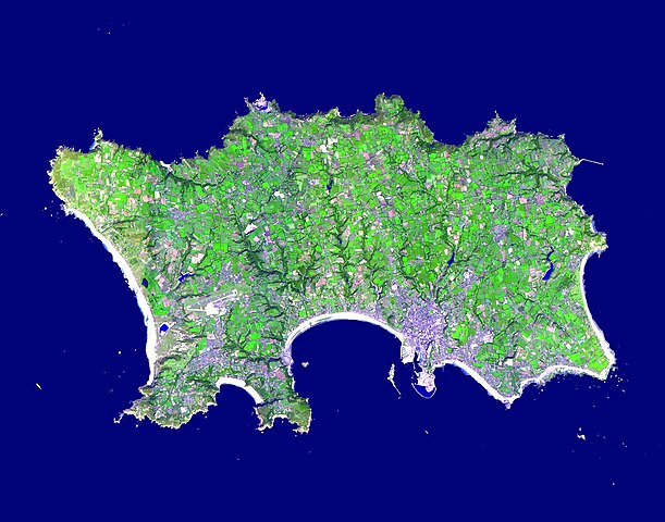
English: The Isle of Jersey (officially called the Bailiwick of Jersey) is the largest Channel Island, positioned in the Bay of Mont St Michel off the north-west coast of France. The island has a population of about 90,000, and covers about 90 square kilometers. The economy is based largely on international financial services, agriculture, and tourism. Called Caesaria in Roman times, Jersey became part of the Duchy of Normandy in 912. When William the Conqueror invaded and took the throne of England in 1066, the fortunes of Jersey then became linked to those in England, although the island manages its internal affairs through its own parliament, the States of Jersey. This image was acquired September 23, 2000, covers an area of 16.5 x 21 km, and is located at 49.2 degrees north latitude and 2.1 degrees west longitude |
||
| 日期 | 攝於2000年九月23日 | ||
| 來源 |
|
||
| 作者 | NASA/METI/AIST/Japan Space Systems, and U.S./Japan ASTER Science Team |
| 拍攝地點 | | 位於此地的本圖片與其他圖片: OpenStreetMap |
|---|
.jpg¶ms=049.200000_N_-002.100000_E_globe:Earth_type:camera__&language=zh-hk)
授權條款
| 本作品由NASA創作,屬於公有領域。根據NASA的版權政策:“NASA的創作除非另有聲明否則不受版權保護。”(參見:Template:PD-USGov/zh,NASA版權政策或JPL圖像使用政策) | ||
 |
警告:
|
檔案歷史
點選日期/時間以檢視該時間的檔案版本。
| 日期/時間 | 縮圖 | 尺寸 | 用戶 | 備註 | |
|---|---|---|---|---|---|
| 目前 | 2023年4月30日 (日) 15:48 | | 1,400 × 1,100(231 KB) | OptimusPrimeBot | #Spacemedia - Upload of https://asterweb.jpl.nasa.gov/gallery/images/jersey.jpg via Commons:Spacemedia |
檔案用途
下列2個頁面有用到此檔案:
全域檔案使用狀況
以下其他 wiki 使用了這個檔案:
- br.wikipedia.org 的使用狀況
- en.wikipedia.org 的使用狀況
- Minquiers and Ecréhous
- Saint Aubin, Jersey
- Les Dirouilles
- Vingtaine de Noirmont
- Vingtaine du Coin
- Vingtaine des Quennevais
- Vingtaine de la Moye
- Vingtaine de Samarès
- Grande Vingtaine (St Clement)
- Vingtaine du Rocquier
- Vingtaine de la Rocque
- Vingtaine des Marais
- Vingtaine de la Rue
- Vingtaine de Longueville
- Vingtaine du Rouge Bouillon
- Vingtaine de Bas du Mont au Prêtre
- Vingtaine du Mont à l'Abbé
- Vingtaine de Haut du Mont au Prêtre
- Vingtaine du Mont Cochon
- St Michael's Preparatory School
- Grouville Church
- St Peter la Rocque
- Vingtaine du Nord (St John)
- Vingtaine de Hérupe
- Vingtaine du Douet (St John)
- Template:Jersey-geo-stub
- Outline of Jersey
- Nicolle Tower
- Vingtaine de la Vallée
- Vingtaine du Coin Hâtain
- Vingtaine du Coin Motier
- Vingtaine du Coin Tourgis Sud
- Les Platons
- HM Prison La Moye
- Vingtaine du Nord (St Mary)
- Grainville School
- St Matthew's Church, Jersey
- Gulf of Saint-Malo
- Samarès Manor
- Saint Ouen's Manor
- FB Playing Fields
- Saint Helier Marina
- Vingtaine du Sud
- Vingtaine de Rozel
- Vingtaine de Faldouet
- Vingtaine de la Quéruée
- Vingtaine des Augrès
- Le Pinacle
- Beaulieu Convent School
檢視此檔案的更多全域使用狀況。
.jpg)
.jpg)