File:State of Burma orthographic map.png

預覽大小:600 × 600 像素。 其他解析度:240 × 240 像素 | 480 × 480 像素 | 1,000 × 1,000 像素。
原始檔案 (1,000 × 1,000 像素,檔案大小:291 KB,MIME 類型:image/png)
摘要
| 描述 |
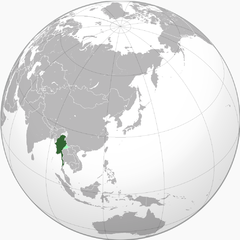
English: Green: Under government authority Light silver: Remainder of Burma Light green: Occupied and annexed by Thailand |
| 日期 | 2010年七月11日 (原始上傳日期) |
| 來源 | Transferred from en.wikipedia to Commons by Shadowxfox. |
| 作者 | 英文維基百科的VoodooIsland |
授權條款
| 此作品已由其作者,英文維基百科的VoodooIsland,釋出至公有領域。此授權條款在全世界均適用。 這可能在某些國家不合法,如果是的話: VoodooIsland授予任何人有權利使用此作品於任何用途,除受法律約束外,不受任何限制。 |
原始上傳日誌
The original description page was here. All following user names refer to en.wikipedia.
- 2010-07-11 05:45 VoodooIsland 1000×1000× (298377 bytes)
- 2010-07-11 05:45 VoodooIsland 1000×1000× (298184 bytes) '''Green''': Under government authority<br>'''Light silver": Remainder of Burma<br>'''Light green''': Occupied and annexed by [[Thailand]]
檔案歷史
點選日期/時間以檢視該時間的檔案版本。
| 日期/時間 | 縮圖 | 尺寸 | 用戶 | 備註 | |
|---|---|---|---|---|---|
| 目前 | 2015年11月6日 (五) 09:06 | | 1,000 × 1,000(291 KB) | Xufanc | Correction; removed conflation of Thai army's farthest penetration into Burma accompanying the Japanese from the actual Japanese sanctioned territories east of the Salween annexed by Thailand |
| 2015年9月16日 (三) 11:40 |  | 1,000 × 1,000(231 KB) | Shoshui | Add Thai occupied territory in Burma. | |
| 2013年3月8日 (五) 00:47 |  | 1,000 × 1,000(291 KB) | OgreBot | (BOT): Reverting to most recent version before archival | |
| 2013年3月8日 (五) 00:47 |  | 1,000 × 1,000(291 KB) | OgreBot | (BOT): Uploading old version of file from en.wikipedia; originally uploaded on 2010-07-11 05:45:04 by VoodooIsland | |
| 2013年3月7日 (四) 16:26 |  | 1,000 × 1,000(291 KB) | Milenioscuro | {{Information |Description={{en|'''Green''': Under government authority<br>'''Light silver": Remainder of Burma<br>'''Light green''': Occupied and annexed by en:Thailand}} |Source=Transferred from [http://en.wikipedia.org en.wikipedia]; transfer ... |
檔案用途
全域檔案使用狀況
以下其他 wiki 使用了這個檔案:
- ar.wikipedia.org 的使用狀況
- bn.wikipedia.org 的使用狀況
- cs.wikipedia.org 的使用狀況
- en.wikipedia.org 的使用狀況
- es.wikipedia.org 的使用狀況
- eu.wikipedia.org 的使用狀況
- fa.wikipedia.org 的使用狀況
- fi.wikipedia.org 的使用狀況
- fr.wikipedia.org 的使用狀況
- ga.wikipedia.org 的使用狀況
- he.wikipedia.org 的使用狀況
- hi.wikipedia.org 的使用狀況
- id.wikipedia.org 的使用狀況
- it.wikipedia.org 的使用狀況
- ja.wikipedia.org 的使用狀況
- ko.wikipedia.org 的使用狀況
- ml.wikipedia.org 的使用狀況
- my.wikipedia.org 的使用狀況
- nl.wikipedia.org 的使用狀況
- pl.wikipedia.org 的使用狀況
- pt.wikipedia.org 的使用狀況
- simple.wikipedia.org 的使用狀況
- smn.wikipedia.org 的使用狀況
- ta.wikipedia.org 的使用狀況
- th.wikipedia.org 的使用狀況
- uk.wikipedia.org 的使用狀況
- vi.wikipedia.org 的使用狀況
- www.wikidata.org 的使用狀況