File:Bairisches Mundartgebiet.PNG
預覽大小:800 × 505 像素。 其他解析度:320 × 202 像素 | 640 × 404 像素 | 1,031 × 651 像素。
原始檔案 (1,031 × 651 像素,檔案大小:43 KB,MIME 類型:image/png)

|
本圖片是以PNG、GIF或JPEG格式上傳。然而,其中包含的資料或訊息,應該重新建立成可縮放向量圖形(SVG)檔案,以更有效率或更準確的方式儲存。如有可能,請上傳本圖片的SVG格式版本。在上傳之後,請修改維基各姊妹計畫中所有使用舊版圖片的條目(列在圖像連結章節中),替換為新版圖片,並在舊圖片的描述頁中加入{{Vector version available|新圖片名稱.svg}}模板,同時移除本模板。
|
摘要
العربية (ar): انتشار اللهجات البافارية الحديثة:
البافارية الشمالية (البالانتية العليا).
البافارية الوسطى (البافارية الدانوبية).
البافارية الجنوبية (البافارية الألبية).
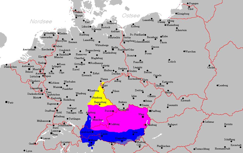
Deutsch (de): Verbreitungsgebiet der heutigen bairischen Mundarten
Nordbairisch
Mittel- oder Donaubairisch
Südbairisch
English (en): Prevalence of modern Bavarian dialects
North Bavarian
Central or Danube Bavarian
South Bavarian
русский (ru): Современные ареалы распространения баварских диалектов
жёлтый: северо-баварский
розовый: среднебаварский (австро (дунайско)-баварский)
синий: южно-баварский
español (es): Distribución del Bavariano.
Baviera del Norte
Baviera central o del Danubio
Baviera del Sur
- design by: Postmann Michael
- Quelle: Selbst erstellt.
- Hinweis: Nach den Vorgaben des "Der Fischer-Informationsatlas der Bundesrepublik Deutschland" (ISBN 3-596-24556-4 Invalid ISBN) von 1990 (S. 63) selbst erstellt. Es wurde sowohl die Karte Westmitteleuropas als auch das bayrische Sprachgebiet vom Autor händisch erstellt. Diese Karte ist gemeinfrei und darf von jedermann verwendet werden!
- Source: Self-made.
- Notes: Information derived from "The Fischer Information Atlas of the Federal Republic of Germany" (ISBN 3-596-24556-4 Invalid ISBN) from 1990 (P. 63). Both the map of west Central Europe and the Bavarian language area were by hand provided by the author. This map is in the public domain and may be used by everyone!
授權條款
| 此作品已由其作者,Postmann Michael,釋出至公有領域。此授權條款在全世界均適用。 這可能在某些國家不合法,如果是的話: |
檔案歷史
點選日期/時間以檢視該時間的檔案版本。
| 日期/時間 | 縮圖 | 尺寸 | 用戶 | 備註 | |
|---|---|---|---|---|---|
| 目前 | 2012年2月18日 (六) 21:22 | | 1,031 × 651(43 KB) | Buachamer | Sechsämterland und Südvogtland hinzugefügt (siehe http://bar.wikipedia.org/wiki/Datei:Bairischer_Sprachraum2.PNG) |
| 2009年4月12日 (日) 17:56 |  | 1,031 × 651(57 KB) | Altaileopard | Nürnberg aus dem bayerischen Dialektraum entfernt. | |
| 2006年3月2日 (四) 04:10 |  | 1,031 × 651(57 KB) | Postmann Michael~commonswiki |
檔案用途
全域檔案使用狀況
以下其他 wiki 使用了這個檔案:
- als.wikipedia.org 的使用狀況
- ar.wikipedia.org 的使用狀況
- ast.wikipedia.org 的使用狀況
- be-tarask.wikipedia.org 的使用狀況
- be.wikipedia.org 的使用狀況
- bg.wikipedia.org 的使用狀況
- br.wikipedia.org 的使用狀況
- ca.wikipedia.org 的使用狀況
- cs.wikipedia.org 的使用狀況
- da.wikipedia.org 的使用狀況
- de.wikipedia.org 的使用狀況
- de.wiktionary.org 的使用狀況
- en.wikipedia.org 的使用狀況
- es.wikipedia.org 的使用狀況
- et.wikipedia.org 的使用狀況
- eu.wikipedia.org 的使用狀況
- fa.wikipedia.org 的使用狀況
- fr.wikipedia.org 的使用狀況
- fy.wikipedia.org 的使用狀況
- ga.wikipedia.org 的使用狀況
- hak.wikipedia.org 的使用狀況
- he.wikipedia.org 的使用狀況
- id.wikipedia.org 的使用狀況
- incubator.wikimedia.org 的使用狀況
- it.wikipedia.org 的使用狀況
檢視此檔案的更多全域使用狀況。