File:Constitution gardens satellite image.jpg
此為最大尺寸。
Constitution_gardens_satellite_image.jpg (650 × 275 像素,檔案大小:123 KB,MIME 類型:image/jpeg)
摘要
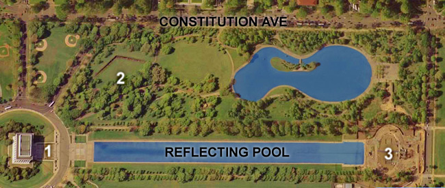
| 描述 | Satellite image of Constitution Gardens, Washington, D.C.. 1) Lincoln Memorial; 2) Vietnam War Memorial; 3) World War II Memorial (then-under construction). |
| 日期 | Satellite image taken in April 2002 |
| 來源 | United States Geological Survey satellite image of the National Mall in Washington, DC. Taken April 26, 2002 (see File:National Mall big satelite image.jpg). |
| 作者 | USGS, cropped and labelled by Postdlf |
3.reflecting pool. 2.constitution garden
授權條款
此作品在美國屬於公有領域,因為其是由美國政府的官員或僱員,基於其個人公務目的製作的作品,參考美國法典第17篇第1章第105條。
注意︰本模板僅適用於美國聯邦政府的原創作品,不適用於任何美國州、屬地、聯邦個體、縣、市或任何次級政府的作品。本模板也不適用於1978年以後由美國郵政署出版的郵票圖案(參看美國版權局實踐綱領第313.6(C)(1)條)。也不適用於部分美國硬幣;參看美國鑄幣局使用條款。 |
 | |
| 此作品無已知的著作權限制,亦不受所有相關和鄰接的權利限制。 | ||
檔案歷史
點選日期/時間以檢視該時間的檔案版本。
| 日期/時間 | 縮圖 | 尺寸 | 用戶 | 備註 | |
|---|---|---|---|---|---|
| 目前 | 2007年9月2日 (日) 22:27 | | 650 × 275(123 KB) | Postdlf | == Summary == {{Information |Description=Map of Constitution Gardens, Washington, D.C. |Source=USGS satellite image |Date=Satellite image taken April 22, 2002 |Author= USGS, cropped and |
檔案用途
下列頁面有用到此檔案:
全域檔案使用狀況
以下其他 wiki 使用了這個檔案:
- ba.wikipedia.org 的使用狀況
- en.wikipedia.org 的使用狀況
- fr.wikipedia.org 的使用狀況
- he.wikipedia.org 的使用狀況
- kk.wikipedia.org 的使用狀況
- lt.wikipedia.org 的使用狀況
- pt.wikipedia.org 的使用狀況