File:First Czechoslovak Republic.SVG

此 SVG 檔案的 PNG 預覽的大小:800 × 377 像素。 其他解析度:320 × 151 像素 | 640 × 302 像素 | 1,024 × 483 像素 | 1,280 × 604 像素 | 2,560 × 1,207 像素 | 1,001 × 472 像素。
原始檔案 (SVG 檔案,表面大小:1,001 × 472 像素,檔案大小:73 KB)
| 描述 |
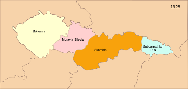
[] Deutsch: Karte der Tschechoslowakischen Republik (1928) English: Map of the First Czechoslovak Republic after 1928 Español: Mapa de la Primera República de Checoslovaquia tras los cambios de administración territorial de 1928 Français : Carte de la Première République tchécoslovaque aprés 1928 Magyar: Az első Csehszlovák Köztársaság 1928-ban Svenska: Karta över den första tjeckoslovakiska republiken efter 1928 Українська: Карта Першої Чехословацької Республіки після 1928 |
| 日期 | (UTC) |
| 來源 | |
| 作者 | 16:36, 13 September 2007 (UTC) |
| 其他版本 |
[]
|


|
This SVG file contains embedded text that can be translated into your language, using any capable SVG editor, text editor or the SVG Translate tool. For more information see: About translating SVG files. |
| 這是一張修飾過的圖片,即本圖片是用軟體修改過後的版本。原版圖片來源:Blank map of Europe - Atelier graphique colors.svg。修改者:Themightyquill。
|
此檔案採用共享創意 姓名標示-相同方式分享 3.0 未在地化版本授權條款。
- 您可以自由:
- 分享 – 複製、發佈和傳播本作品
- 重新修改 – 創作演繹作品
- 惟需遵照下列條件:
- 姓名標示 – 您必須指名出正確的製作者,和提供授權條款的連結,以及表示是否有對內容上做出變更。您可以用任何合理的方式來行動,但不得以任何方式表明授權條款是對您許可或是由您所使用。
- 相同方式分享 – 如果您利用本素材進行再混合、轉換或創作,您必須基於如同原先的相同或兼容的條款,來分布您的貢獻成品。
原始上傳日誌
This image is a derivative work of the following images:
- Image:Czechoslovakia01.png licensed with PD-self
- 2006-12-28T16:11:35Z Electionworld 1100x497 (92110 Bytes) {{ew|en|PANONIAN}} Map of {{link|Czechoslovakia}} (self made) Note: The provinces shown on the map were introduced by Act No. 125/1927 Zb. and became effective in 1928. {{PD-self}} [[Category:Maps of Czechoslovakia]] [[Cat
- Image:Blank_map_of_Europe_-_Atelier_graphique_colors.svg licensed with Cc-by-sa-2.5,2.0,1.0, GFDL
- 2007-09-16T15:08:27Z Historicair 841x731 (495651 Bytes) '
- 2007-09-13T16:36:42Z Historicair 841x731 (495370 Bytes) {{Information |Description={{fr|Carte vierge de l'Europe, couleurs Atelier Graphique}} {{en|Blank map of Europe with Atelier graphique colors}} |Source=[[:Image:Europe countries.svg]] by [[User:Tintazul|Tintazul]] |Date=13/09
Uploaded with derivativeFX
檔案歷史
點選日期/時間以檢視該時間的檔案版本。
| 日期/時間 | 縮圖 | 尺寸 | 用戶 | 備註 | |
|---|---|---|---|---|---|
| 目前 | 2024年7月9日 (二) 16:16 | | 1,001 × 472(73 KB) | Koldo Biguri | File uploaded using svgtranslate tool (https://svgtranslate.toolforge.org/). Added translation for eu. |
| 2008年6月10日 (二) 13:57 |  | 1,001 × 472(69 KB) | Themightyquill | ||
| 2008年6月10日 (二) 13:19 |  | 1,001 × 471(72 KB) | Themightyquill | ||
| 2008年6月9日 (一) 22:27 |  | 1,001 × 471(59 KB) | Themightyquill | ||
| 2008年6月9日 (一) 15:42 |  | 1,001 × 471(394 KB) | Themightyquill | ||
| 2008年6月8日 (日) 23:43 |  | 1,001 × 471(67 KB) | Themightyquill | ||
| 2008年6月8日 (日) 23:40 |  | 1,100 × 497(67 KB) | Themightyquill | {{Information |Description={{fr|Carte vierge de l'Europe, couleurs Atelier Graphique}} {{en|Blank map of Europe with Atelier graphique colors}} |Source=*Image:Czechoslovakia01.png *Image:Blank_map_of_Europe_-_Atelier_graphique_colors.svg |Date |
檔案用途
下列頁面有用到此檔案:
全域檔案使用狀況
以下其他 wiki 使用了這個檔案:
- ba.wikipedia.org 的使用狀況
- cs.wikipedia.org 的使用狀況
- en.wikipedia.org 的使用狀況
- eu.wikipedia.org 的使用狀況
- ru.wikipedia.org 的使用狀況