File:GranChacoApproximate.jpg
預覽大小:800 × 585 像素。 其他解析度:320 × 234 像素 | 640 × 468 像素 | 1,024 × 749 像素 | 1,280 × 936 像素 | 1,740 × 1,273 像素。
原始檔案 (1,740 × 1,273 像素,檔案大小:458 KB,MIME 類型:image/jpeg)
| 描述 |
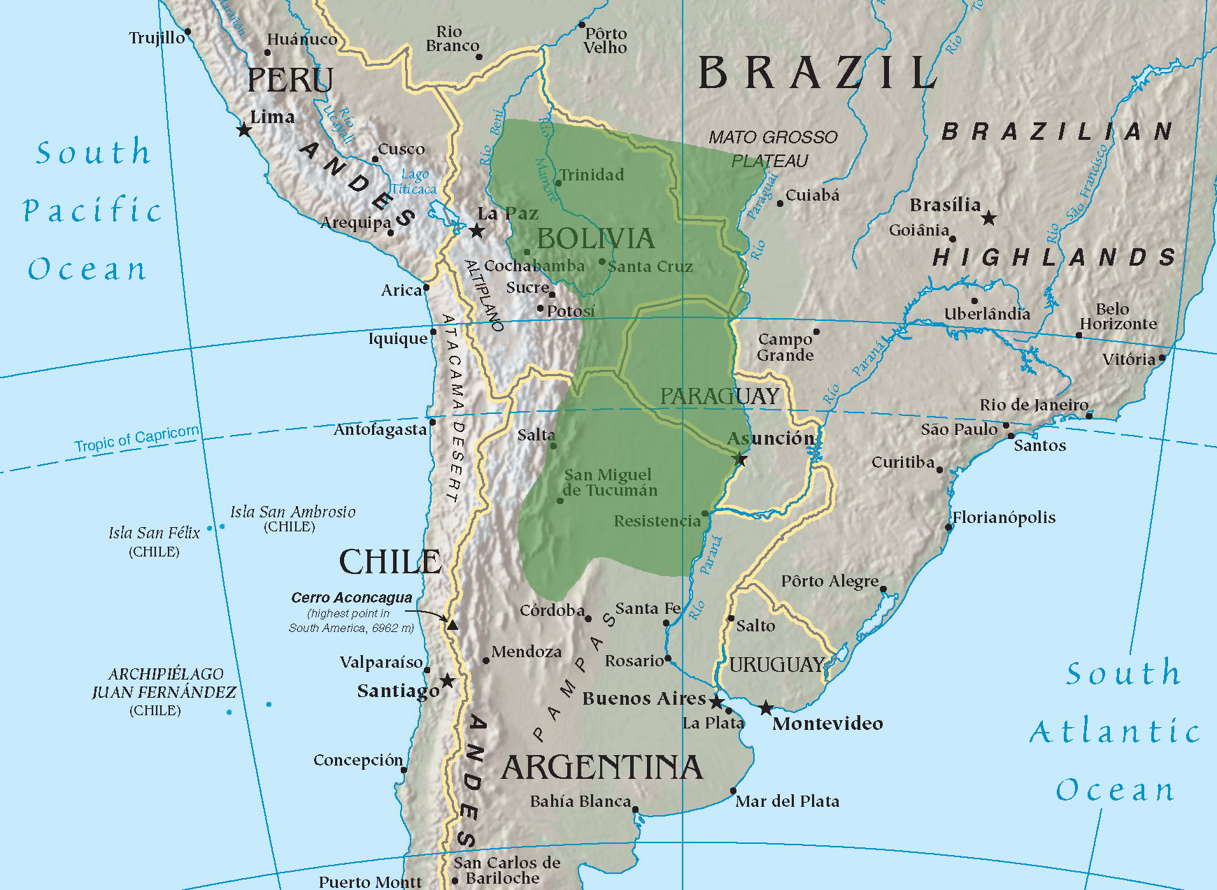
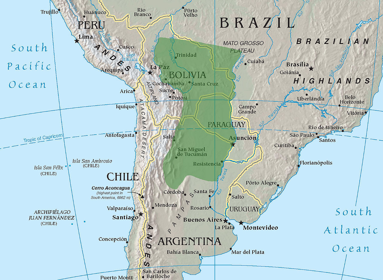
English: Very approximate location of the Gran Chaco (Underlying map taken from the CIA World Factbook)
Українська: Приблизна територія Гран-Чако
Français : Situation approximative de la région Gran Chaco (carte provenant du CIA World Factbook). |
| 日期 | 2004年10月26日 (原始上傳日期) |
| 來源 | Transferred from en.wikipedia to Commons by Dmitri Lytov using CommonsHelper. |
| 作者 | 英文維基百科的Flyhighplato |
授權條款
|
本作品在其來源國以及其他版權期限是作者逝世後70年或以下的國家與地區屬於公有領域。 | |
| 此作品無已知的著作權限制,亦不受所有相關和鄰接的權利限制。 | |
| 此作品已由其作者,英文維基百科的Flyhighplato,釋出至公有領域。此授權條款在全世界均適用。 這可能在某些國家不合法,如果是的話: Flyhighplato授予任何人有權利使用此作品於任何用途,除受法律約束外,不受任何限制。 |
原始上傳日誌
The original description page was here. All following user names refer to en.wikipedia.
- 2004-10-26 14:07 Flyhighplato 1740×1273× (469401 bytes) Very approximate location of the Gran Chaco
檔案歷史
點選日期/時間以檢視該時間的檔案版本。
| 日期/時間 | 縮圖 | 尺寸 | 用戶 | 備註 | |
|---|---|---|---|---|---|
| 目前 | 2009年11月19日 (四) 19:04 | | 1,740 × 1,273(458 KB) | File Upload Bot (Magnus Manske) | {{BotMoveToCommons|en.wikipedia|year={{subst:CURRENTYEAR}}|month={{subst:CURRENTMONTHNAME}}|day={{subst:CURRENTDAY}}}} {{Information |Description={{en|Very approximate location of the Gran Chaco (Underlying map taken from the CIA World Factbook)}} |Sourc |
檔案用途
下列頁面有用到此檔案:
全域檔案使用狀況
以下其他 wiki 使用了這個檔案:
- ar.wikipedia.org 的使用狀況
- az.wikipedia.org 的使用狀況
- be.wikipedia.org 的使用狀況
- bg.wikipedia.org 的使用狀況
- bs.wikipedia.org 的使用狀況
- ca.wikipedia.org 的使用狀況
- cs.wikipedia.org 的使用狀況
- en.wikipedia.org 的使用狀況
- eo.wikipedia.org 的使用狀況
- es.wikipedia.org 的使用狀況
- eu.wikipedia.org 的使用狀況
- fa.wikipedia.org 的使用狀況
- fi.wikipedia.org 的使用狀況
- fr.wikipedia.org 的使用狀況
- fr.wiktionary.org 的使用狀況
- gl.wikipedia.org 的使用狀況
- hu.wikipedia.org 的使用狀況
- it.wikipedia.org 的使用狀況
- ka.wikipedia.org 的使用狀況
- kk.wikipedia.org 的使用狀況
- ky.wikipedia.org 的使用狀況
- lfn.wikipedia.org 的使用狀況
- lt.wikipedia.org 的使用狀況
- lv.wikipedia.org 的使用狀況
- mk.wikipedia.org 的使用狀況
- ml.wikipedia.org 的使用狀況
- nl.wikipedia.org 的使用狀況
- pl.wikipedia.org 的使用狀況
- pt.wikipedia.org 的使用狀況
- pt.wikiversity.org 的使用狀況
- ru.wikipedia.org 的使用狀況
- sh.wikipedia.org 的使用狀況
- sv.wikipedia.org 的使用狀況
- ta.wikipedia.org 的使用狀況
- tg.wikipedia.org 的使用狀況
- tr.wikipedia.org 的使用狀況
- uk.wikipedia.org 的使用狀況
檢視此檔案的更多全域使用狀況。