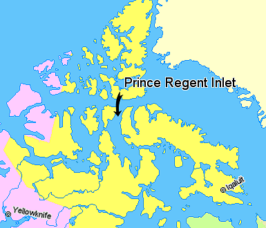
File:Map indicating Prince Regent Inlet, Nunavut, Canada.png
Map_indicating_Prince_Regent_Inlet,_Nunavut,_Canada.png (385 × 330 像素,檔案大小:56 KB,MIME 類型:image/png)
檔案歷史
點選日期/時間以檢視該時間的檔案版本。
| 日期/時間 | 縮圖 | 尺寸 | 用戶 | 備註 | |
|---|---|---|---|---|---|
| 目前 | 2006年3月22日 (三) 02:31 |  | 385 × 330(56 KB) | David Kernow~commonswiki | == Summary == Map indicating Prince Regent Inlet, Nunavut, Canada. {{legend|#ffff66|Nunavut}} {{legend|#ffccff|Northwest Territories}} {{legend|#ffffcc|Greenland}} <br> © Her Majesty the Queen in Right of Canada, Department |
檔案用途
全域檔案使用狀況
以下其他 wiki 使用了這個檔案:
- az.wikipedia.org 的使用狀況
- bg.wikipedia.org 的使用狀況
- de.wikipedia.org 的使用狀況
- en.wikipedia.org 的使用狀況
- es.wikipedia.org 的使用狀況
- fr.wikipedia.org 的使用狀況
- ja.wikipedia.org 的使用狀況
- nl.wikipedia.org 的使用狀況
- pl.wikipedia.org 的使用狀況
- pt.wikipedia.org 的使用狀況


