File:Map of Yosemite National Park.svg

此 SVG 檔案的 PNG 預覽的大小:692 × 599 像素。 其他解析度:277 × 240 像素 | 554 × 480 像素 | 887 × 768 像素 | 1,183 × 1,024 像素 | 2,365 × 2,048 像素 | 746 × 646 像素。
原始檔案 (SVG 檔案,表面大小:746 × 646 像素,檔案大小:313 KB)
摘要
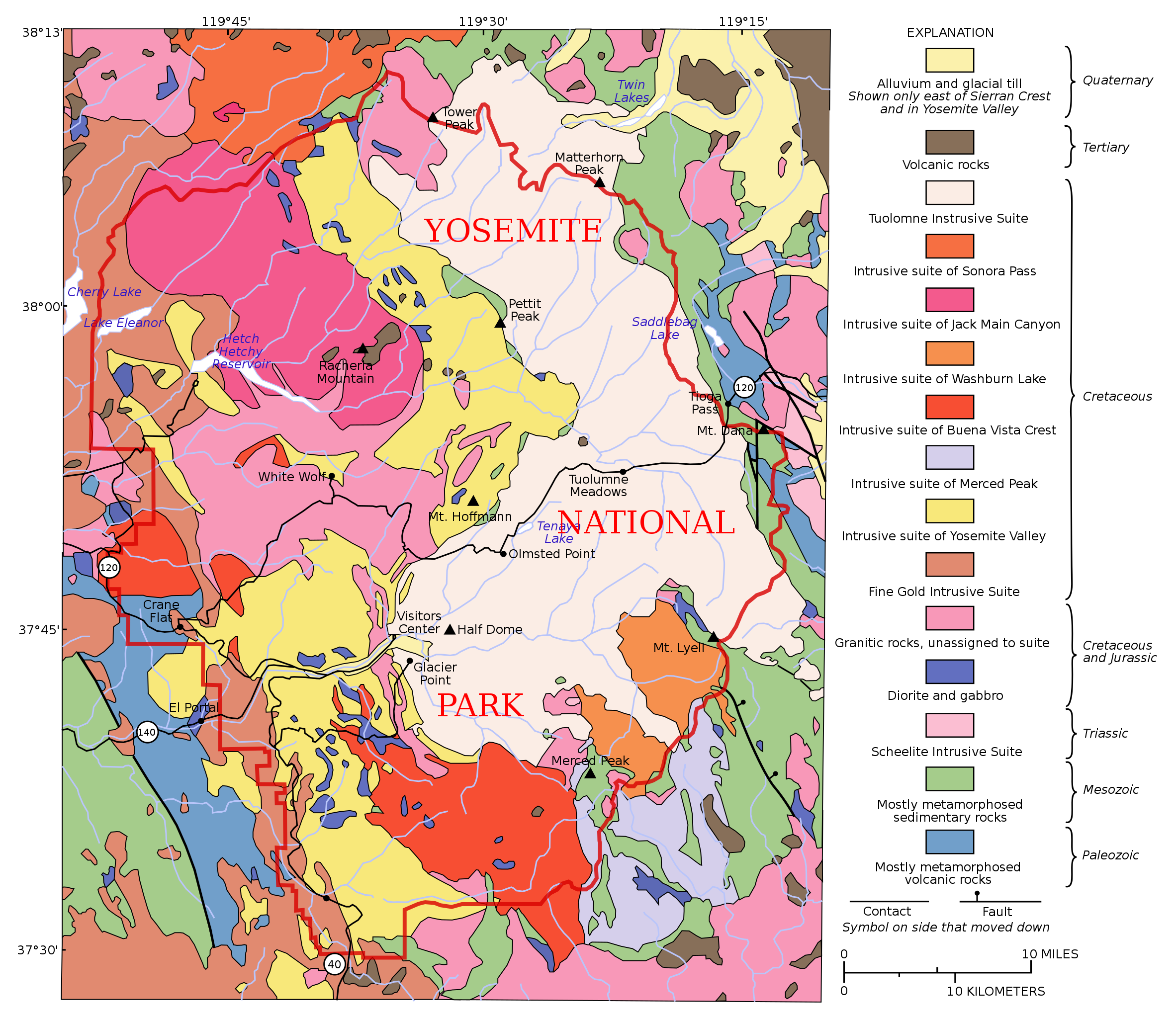
| 描述 | Map of Yosemite National Park based on a map by the USGS image from here. Original notes that the data was "generalized from geological map of Yosemite National Park and vicinity (Huber and others, in press)" and that "an intrusive suite is a grouping of genetically related plutonic rocks". |
| 日期 | (UTC) |
| 來源 |
本檔案衍生自: General geologic map of Yosemite area.png: |
| 作者 | |
| 其他版本 | Derivative works of this file: Map of Cathedral Peak Granodiorite.svg |
授權條款
此檔案採用共享創意 姓名標示-相同方式分享 3.0 未在地化版本授權條款。
- 您可以自由:
- 分享 – 複製、發佈和傳播本作品
- 重新修改 – 創作演繹作品
- 惟需遵照下列條件:
- 姓名標示 – 您必須指名出正確的製作者,和提供授權條款的連結,以及表示是否有對內容上做出變更。您可以用任何合理的方式來行動,但不得以任何方式表明授權條款是對您許可或是由您所使用。
- 相同方式分享 – 如果您利用本素材進行再混合、轉換或創作,您必須基於如同原先的相同或兼容的條款,來分布您的貢獻成品。
原始上傳日誌
This image is a derivative work of the following images:
- File:General_geologic_map_of_Yosemite_area.png licensed with PD-USGov-USGS
- 2007-03-03T15:24:43Z Urban 734x666 (741890 Bytes) [[Category:Yosemite National Park]] uploaded from : http://en.wikipedia.org/wiki/Image:General_geologic_map_of_Yosemite_area.png PD USGS image from http://geology.wr.usgs.gov/docs/usgsnps/yos/yosmap.html {{PD-USGov-USGS}}
Uploaded with derivativeFX
檔案歷史
點選日期/時間以檢視該時間的檔案版本。
| 日期/時間 | 縮圖 | 尺寸 | 用戶 | 備註 | |
|---|---|---|---|---|---|
| 目前 | 2012年5月25日 (五) 22:07 | | 746 × 646(313 KB) | Grandiose | Hopefully restore rivers |
| 2012年5月23日 (三) 21:25 |  | 746 × 646(1.27 MB) | Grandiose | == {{int:filedesc}} == {{Information |Description=uploaded from : http://en.wikipedia.org/wiki/Image:General_geologic_map_of_Yosemite_area.png Other version: File:Cathedral Peak Granodiorit.png PD USGS image from http://geology.wr.usgs.gov/docs/... |
檔案用途
下列頁面有用到此檔案:
全域檔案使用狀況
以下其他 wiki 使用了這個檔案:
- en.wikipedia.org 的使用狀況
- Yosemite National Park
- Geology of the Yosemite area
- Wikipedia:Featured picture candidates/May-2012
- Wikipedia:Featured picture candidates/Map of Yosemite National Park
- Tuolumne Intrusive Suite
- Fine Gold Intrusive Suite
- Intrusive Suite of Buena Vista Crest
- Intrusive Suite of Yosemite Valley
- Intrusive Suite of Sonora Pass
- Intrusive Suite of Merced Peak
- nl.wikipedia.org 的使用狀況
- sl.wikipedia.org 的使用狀況