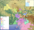
File:Map of the Benue–Congo languages of Nigeria and Cameroon.svg

此 SVG 檔案的 PNG 預覽的大小:687 × 599 像素。 其他解析度:275 × 240 像素 | 550 × 480 像素 | 881 × 768 像素 | 1,174 × 1,024 像素 | 2,348 × 2,048 像素 | 1,362 × 1,188 像素。
原始檔案 (SVG 檔案,表面大小:1,362 × 1,188 像素,檔案大小:16.58 MB)
檔案歷史
點選日期/時間以檢視該時間的檔案版本。
| 日期/時間 | 縮圖 | 尺寸 | 用戶 | 備註 | |
|---|---|---|---|---|---|
| 目前 | 2017年8月14日 (一) 18:36 |  | 1,362 × 1,188(16.58 MB) | SUM1 | Fixed Southern Bantoid boundary (added gaps for Nyong) |
| 2017年8月5日 (六) 14:47 |  | 1,362 × 1,188(16.57 MB) | SUM1 | Fixed Southern Bantoid boundary (near Cross River) | |
| 2017年8月1日 (二) 19:41 |  | 1,362 × 1,188(16.57 MB) | SUM1 | Fixed Chad label | |
| 2017年7月27日 (四) 12:04 |  | 1,362 × 1,188(16.57 MB) | SUM1 | Added O'chi'chi' (Cross River) | |
| 2017年7月27日 (四) 01:12 |  | 1,362 × 1,188(16.57 MB) | SUM1 | Fixed Cross River position and reclassified Bendi as Southern Bantoid | |
| 2017年7月26日 (三) 17:37 |  | 1,362 × 1,188(16.58 MB) | SUM1 | Added Jan Awei language (Jukunoid) | |
| 2017年7月20日 (四) 14:47 |  | 1,362 × 1,188(16.58 MB) | SUM1 | Differenced to prevent further overlap | |
| 2017年7月20日 (四) 14:45 |  | 1,362 × 1,188(16.58 MB) | SUM1 | Fixed Plateau overlap of Kainji | |
| 2017年7月17日 (一) 22:19 |  | 1,362 × 1,188(16.58 MB) | SUM1 | Removed unnecessary layers to reduce file size | |
| 2017年7月17日 (一) 21:17 |  | 1,362 × 1,188(21.07 MB) | SUM1 | Added zoom map |
檔案用途
下列頁面有用到此檔案:
全域檔案使用狀況
以下其他 wiki 使用了這個檔案:
- en.wikipedia.org 的使用狀況
- ru.wikipedia.org 的使用狀況
