File:NEFA1961.png

預覽大小:800 × 459 像素。 其他解析度:320 × 184 像素 | 640 × 367 像素 | 1,024 × 588 像素 | 1,280 × 735 像素 | 1,820 × 1,045 像素。
原始檔案 (1,820 × 1,045 像素,檔案大小:186 KB,MIME 類型:image/png)
摘要
| 描述 |
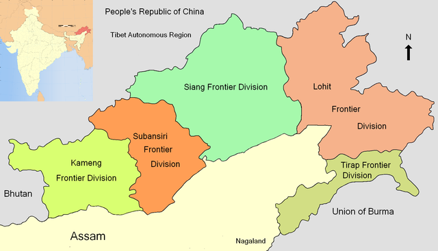
English: A Locator map of North East Frontier Agency in 1961. |
|||
| 日期 | ||||
| 來源 | 自己的作品 based on image:Arunachal Pradesh locator map.svg by User:Planemad, inset is based on image:India Arunachal Pradesh locator map.svg by User:Planemad | |||
| 作者 | Joy1963 | |||
| 其他版本 |
|


授權條款
我,本作品的著作權持有者,決定用以下授權條款發佈本作品:
此檔案採用共享創意 姓名標示-相同方式分享 3.0 未在地化版本授權條款。
- 您可以自由:
- 分享 – 複製、發佈和傳播本作品
- 重新修改 – 創作演繹作品
- 惟需遵照下列條件:
- 姓名標示 – 您必須指名出正確的製作者,和提供授權條款的連結,以及表示是否有對內容上做出變更。您可以用任何合理的方式來行動,但不得以任何方式表明授權條款是對您許可或是由您所使用。
- 相同方式分享 – 如果您利用本素材進行再混合、轉換或創作,您必須基於如同原先的相同或兼容的條款,來分布您的貢獻成品。

|
已授權您依據自由軟體基金會發行的無固定段落、封面文字和封底文字GNU自由文件授權條款1.2版或任意後續版本,對本檔進行複製、傳播和/或修改。該協議的副本列在GNU自由文件授權條款中。 |
您可以選擇您需要的授權條款。
檔案歷史
點選日期/時間以檢視該時間的檔案版本。
| 日期/時間 | 縮圖 | 尺寸 | 用戶 | 備註 | |
|---|---|---|---|---|---|
| 目前 | 2009年11月8日 (日) 16:46 | | 1,820 × 1,045(186 KB) | Joy1963 | {{Information |Description={{en|1=A Locator map of North East Frontier Agency in 1961.}} |Source={{own}} based on image:Arunachal Pradesh locator map.svg by User:Planemad, inset is based on image:India Arunachal Pradesh locator map.svg by [[ |
檔案用途
下列頁面有用到此檔案:
全域檔案使用狀況
以下其他 wiki 使用了這個檔案:
- bn.wikipedia.org 的使用狀況
- en.wikipedia.org 的使用狀況
- fr.wikipedia.org 的使用狀況
- he.wikipedia.org 的使用狀況
- hi.wikipedia.org 的使用狀況
- pa.wikipedia.org 的使用狀況
- pnb.wikipedia.org 的使用狀況
- ru.wikipedia.org 的使用狀況
- ta.wikipedia.org 的使用狀況
- ur.wikipedia.org 的使用狀況