File:North West England counties 2023 map.svg

此 SVG 檔案的 PNG 預覽的大小:300 × 599 像素。 其他解析度:120 × 240 像素 | 240 × 480 像素 | 385 × 768 像素 | 513 × 1,024 像素 | 1,026 × 2,048 像素 | 674 × 1,345 像素。
原始檔案 (SVG 檔案,表面大小:674 × 1,345 像素,檔案大小:1.38 MB)
摘要
| 描述 |
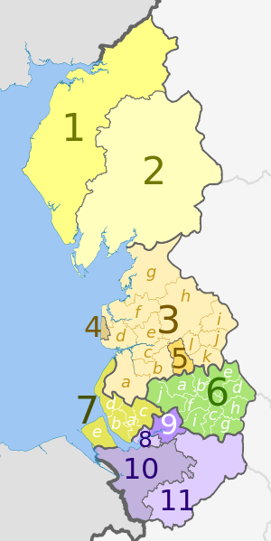
English: Map of the North West region of England, showing its counties and administrative districts since 1 April 2023. The county colours are the same as those in File:English metropolitan and non-metropolitan counties 2009.svg.
Equirectangular map projection on WGS 84 datum, with N/S stretched 160% Geographic limits:
|
| 日期 | |
| 來源 |
本檔案衍生自: North West England counties 2009 map.svg:  |
| 作者 |
Key
| Strategic authority |
Ceremonial county |
Metropolitan or non-metropolitan county |
Metropolitan or non-metropolitan districts May also hold borough and/or city status |
|---|---|---|---|
| Cumbria | 1. Cumberland U.A. | ||
| 2. Westmorland and Furness U.A | |||
| Lancashire | 3. Lancashire † | a) West Lancashire, b) Chorley, c) South Ribble, d) Fylde, e) Preston, f) Wyre, g) Lancaster, h) Ribble Valley, i) Pendle, j) Burnley, k) Rossendale, l) Hyndburn | |
| 4. Blackpool U.A. | |||
| 5. Blackburn with Darwen U.A. | |||
| Greater Manchester | 6. Greater Manchester * | a) Bolton, b) Bury, c) Manchester, d) Oldham, e) Rochdale, f) Salford, g) Stockport, h) Tameside, i) Trafford, j) Wigan | |
| Liverpool City Region | 7. Merseyside * | a) Knowsley, b) Liverpool, c) St. Helens, d) Sefton, e) Wirral | |
| Cheshire | 8. Halton U.A. | ||
| 9. Warrington U.A. | |||
| 10. Cheshire West and Chester U.A. | |||
| 11. Cheshire East U.A. | |||
† Two-tier non-metropolitan county |
|||
U.A. Unitary authority area (non-metropolitan county and district)
| |||
| (no county council) | |||
授權條款
此檔案採用共享創意 姓名標示-相同方式分享 3.0 未在地化版本授權條款。
姓名標示: Dr Greg and Nilfanion. Contains Ordnance Survey data © Crown copyright and database right 2010
- 您可以自由:
- 分享 – 複製、發佈和傳播本作品
- 重新修改 – 創作演繹作品
- 惟需遵照下列條件:
- 姓名標示 – 您必須指名出正確的製作者,和提供授權條款的連結,以及表示是否有對內容上做出變更。您可以用任何合理的方式來行動,但不得以任何方式表明授權條款是對您許可或是由您所使用。
- 相同方式分享 – 如果您利用本素材進行再混合、轉換或創作,您必須基於如同原先的相同或兼容的條款,來分布您的貢獻成品。
檔案歷史
點選日期/時間以檢視該時間的檔案版本。
| 日期/時間 | 縮圖 | 尺寸 | 用戶 | 備註 | |
|---|---|---|---|---|---|
| 目前 | 2023年5月28日 (日) 20:32 | | 674 × 1,345(1.38 MB) | Dr Greg | Uploaded a work by * ''North West England counties 2009 map.svg'': Dr Greg and Nilfanion, contains Ordnance Survey data * derivative work: Dr Greg from {{Derived from|North West England counties 2009 map.svg|display=50}} with UploadWizard |
檔案用途
下列頁面有用到此檔案:
全域檔案使用狀況
以下其他 wiki 使用了這個檔案:
- de.wikipedia.org 的使用狀況
- en.wikipedia.org 的使用狀況
- fr.wikipedia.org 的使用狀況