File:PIA16105 malin04ano-br2.jpg

原始檔案 (1,024 × 684 像素,檔案大小:125 KB,MIME 類型:image/jpeg)
摘要
| 描述 |
English: 08.27.2012
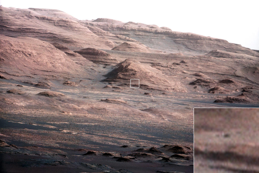
Layers at the Base of Mount Sharp A chapter of the layered geological history of Mars is laid bare in this postcard from NASA's Curiosity rover. The image shows the base of Mount Sharp, the rover's eventual science destination. This image is a portion of a larger image taken by Curiosity's 100-millimeter Mast Camera on Aug. 23, 2012. See http://photojournal.jpl.nasa.gov/catalog/PIA16104. Scientists enhanced the color in one version to show the Martian scene under the lighting conditions we have on Earth, which helps in analyzing the terrain. For scale, an annotated version of the figure highlights a dark rock that is approximately the same size as Curiosity. The pointy mound in the center of the image, looming above the rover-sized rock, is about 1,000 feet (300 meters) across and 300 feet (100 meters) high. To see a close-up of the layered buttes of Mount Sharp, see http://photojournal.jpl.nasa.gov/catalog/PIA16105. Image Credit: NASA/JPL-Caltech/MSSS |
| 日期 | |
| 來源 | http://mars.jpl.nasa.gov/msl/images/PIA16105_malin04ano-br2.jpg |
| 作者 | NASA/JPL-Caltech/MSSS |
授權條款
| 本作品由NASA創作,屬於公有領域。根據NASA的版權政策:“NASA的創作除非另有聲明否則不受版權保護。”(參見:Template:PD-USGov/zh,NASA版權政策或JPL圖像使用政策) | ||
 |
警告:
|
檔案歷史
點選日期/時間以檢視該時間的檔案版本。
| 日期/時間 | 縮圖 | 尺寸 | 用戶 | 備註 | |
|---|---|---|---|---|---|
| 目前 | 2012年8月27日 (一) 23:44 | | 1,024 × 684(125 KB) | Drbogdan | User created page with UploadWizard |
檔案用途
下列4個頁面有用到此檔案:
全域檔案使用狀況
以下其他 wiki 使用了這個檔案:
- bn.wikipedia.org 的使用狀況
- ca.wikipedia.org 的使用狀況
- en.wikipedia.org 的使用狀況
- es.wikipedia.org 的使用狀況
- fa.wikipedia.org 的使用狀況
- kk.wikipedia.org 的使用狀況
- ko.wikipedia.org 的使用狀況
- ro.wikipedia.org 的使用狀況
- test.wikipedia.org 的使用狀況
- tr.wikipedia.org 的使用狀況
- uk.wikipedia.org 的使用狀況