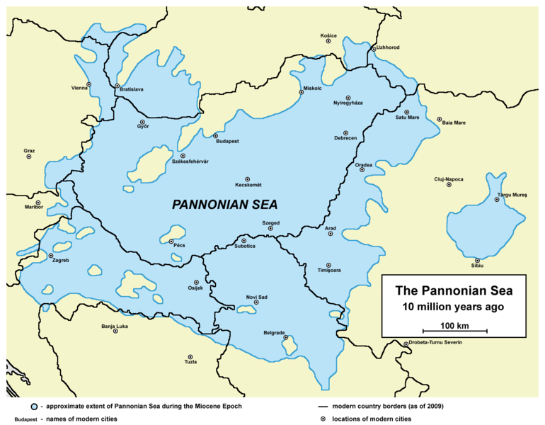
File:Pannoniansea currentborders.png

預覽大小:770 × 600 像素。 其他解析度:308 × 240 像素 | 617 × 480 像素 | 986 × 768 像素 | 1,280 × 997 像素 | 1,536 × 1,196 像素。
原始檔案 (1,536 × 1,196 像素,檔案大小:119 KB,MIME 類型:image/png)
檔案歷史
點選日期/時間以檢視該時間的檔案版本。
| 日期/時間 | 縮圖 | 尺寸 | 用戶 | 備註 | |
|---|---|---|---|---|---|
| 目前 | 2014年2月5日 (三) 17:26 |  | 1,536 × 1,196(119 KB) | WikiEditor2004 | correcting some errors as modern country borders were not fully accurate fixed on sea borders + some aesthetical improvement |
| 2009年8月23日 (日) 11:20 |  | 1,465 × 1,061(124 KB) | Qorilla | date error | |
| 2009年8月23日 (日) 11:12 |  | 1,465 × 1,061(125 KB) | Qorilla | {{Information |Description=* '''English:''' approximate extent of Pannonian Sea during the Miocene Epoch with modern borders and settlements '''Internet references:''' * [http://www.sulinet.hu/oroksegtar/data/telepulesek_ertekei/Ruzsa/pages/ruzsa_tortene |
檔案用途
下列頁面有用到此檔案:
全域檔案使用狀況
以下其他 wiki 使用了這個檔案:
- arz.wikipedia.org 的使用狀況
- bg.wikipedia.org 的使用狀況
- el.wikipedia.org 的使用狀況
- en.wikipedia.org 的使用狀況
- es.wikipedia.org 的使用狀況
- fr.wikipedia.org 的使用狀況
- id.wikipedia.org 的使用狀況
- ja.wikipedia.org 的使用狀況
- kk.wikipedia.org 的使用狀況
- ko.wikipedia.org 的使用狀況
- nn.wikipedia.org 的使用狀況
- no.wikipedia.org 的使用狀況
- pl.wikipedia.org 的使用狀況
- ro.wikipedia.org 的使用狀況
- ru.wikipedia.org 的使用狀況
- www.wikidata.org 的使用狀況
