File:Sri Lanka geopolitics - after "Spoiling of Vijayabahu".png

原始檔案 (2,441 × 3,257 像素,檔案大小:575 KB,MIME 類型:image/png)
摘要
| 描述 |
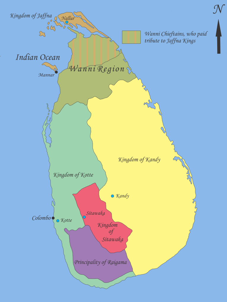
English: Map showing geopolitical situation in Sri Lanka in the early part of 16th century after the “Spoiling of Vijayabahu” in 1521. Map based on following sources;
- “Year 8 History Text Book – Government Publication”, THE ARRIVAL OF THE PORTUGUESE IN SRI LANKA: p14, 06th September 2012. -Fernao de Queyroz. The temporal and spiritual conquest of Ceylon. AES reprint. New Delhi: Asian Educational Services; 1995. p 47-58 ISBN 81-206-0765-1 -Captain Joao Ribeiro. The historic Tragedy of the island of Ceilao. AES Reprint. New Delhi: Asian Educational Services; 1999. p5 ISBN 81-206-1334-1 -Phillipus Baldaeus. A True and Exact Description of the Great Island of Ceylon. English Translation by Pieter Brohier. The Ceylon Historical Journal – Published in Co-operation with the Ceylon Branch of Royal Asiatic Society. Volume III, No 1-4; July 1958 to April 1959. p 300-301 Following maps were used to identify limitations of areas and not for the map itself. -DE L'ISLE:G. - Carte de l'Isle de Ceylan. Published in Paris 1723. http://www.swaen.com/antique-map-of.php?id=1777 , 06 September 2012 - VALENTIJN,F. - Nieuwe Kaart van het Eyland Ceylon opgestelt door. Published in Amsterdam 1724 http://www.swaen.com/antique-map-of.php?id=736 |
| 日期 | |
| 來源 | 自己的作品 |
| 作者 | Nishadhi |
授權條款
- 您可以自由:
- 分享 – 複製、發佈和傳播本作品
- 重新修改 – 創作演繹作品
- 惟需遵照下列條件:
- 姓名標示 – 您必須指名出正確的製作者,和提供授權條款的連結,以及表示是否有對內容上做出變更。您可以用任何合理的方式來行動,但不得以任何方式表明授權條款是對您許可或是由您所使用。
- 相同方式分享 – 如果您利用本素材進行再混合、轉換或創作,您必須基於如同原先的相同或兼容的條款,來分布您的貢獻成品。

|
已授權您依據自由軟體基金會發行的無固定段落、封面文字和封底文字GNU自由文件授權條款1.2版或任意後續版本,對本檔進行複製、傳播和/或修改。該協議的副本列在GNU自由文件授權條款中。 |
原始上傳日誌
- 2012-09-21 18:02 Nishadhi 2441×3257× (589067 bytes) Spelling mistake corrected.
- 2012-09-16 15:48 Nishadhi 2441×3257× (589023 bytes) Map showing geopolitical situation in Sri Lanka in the early part of 16th century after the “Spoiling of Vijayabahu” in 1521. Map based on following sources; - “Year 8 History Text Book – Government Publication”, THE ARRIVAL OF THE PORTUGUESE...
檔案歷史
點選日期/時間以檢視該時間的檔案版本。
| 日期/時間 | 縮圖 | 尺寸 | 用戶 | 備註 | |
|---|---|---|---|---|---|
| 目前 | 2014年12月25日 (四) 19:04 | | 2,441 × 3,257(575 KB) | OgreBot | (BOT): Reverting to most recent version before archival |
| 2014年12月25日 (四) 19:04 |  | 2,441 × 3,257(575 KB) | OgreBot | (BOT): Uploading old version of file from en.wikipedia; originally uploaded on 2012-09-16 15:48:39 by Nishadhi | |
| 2012年9月21日 (五) 18:25 |  | 2,441 × 3,257(575 KB) | Nishadhi | {{Information |Description ={{en|1=Map showing geopolitical situation in Sri Lanka in the early part of 16th century after the “Spoiling of Vijayabahu” in 1521. Map based on following sources; - “Year 8 History Text Book – Government Public... |
檔案用途
全域檔案使用狀況
以下其他 wiki 使用了這個檔案:
- ca.wikipedia.org 的使用狀況
- de.wikipedia.org 的使用狀況
- en.wikipedia.org 的使用狀況
- Bayinnaung
- Kingdom of Kandy
- Vanni chieftaincies
- Vijayabā Kollaya
- Kingdom of Kotte
- User:Blackknight12/sandbox
- User:Nishadhi
- Siege of Kotte (1557–1558)
- Campaign of Danture
- Siege of Galle (1640)
- Sinhalese–Portuguese conflicts
- Sinhalese monarchy
- Transitional period of Sri Lanka
- User:Tisquesusa/sandbox9
- User:Blackknight12/sandbox2
- Myanmar–Sri Lanka relations
- fi.wikipedia.org 的使用狀況
- fr.wikipedia.org 的使用狀況
- it.wikipedia.org 的使用狀況
- ka.wikipedia.org 的使用狀況
- ko.wikipedia.org 的使用狀況
- my.wikipedia.org 的使用狀況
- nl.wikipedia.org 的使用狀況
- pl.wikipedia.org 的使用狀況
- pt.wikipedia.org 的使用狀況
- si.wikipedia.org 的使用狀況
- sl.wikipedia.org 的使用狀況
- ta.wikipedia.org 的使用狀況
- ur.wikipedia.org 的使用狀況