File:World in 2000 BC.svg

此 SVG 檔案的 PNG 預覽的大小:800 × 397 像素。 其他解析度:320 × 159 像素 | 640 × 318 像素 | 1,024 × 508 像素 | 1,280 × 635 像素 | 2,560 × 1,271 像素 | 4,500 × 2,234 像素。
原始檔案 (SVG 檔案,表面大小:4,500 × 2,234 像素,檔案大小:847 KB)
Edit it
摘要
| 描述 |
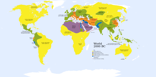
English: A map of the world, circa 2000 BC
Ελληνικά: Πολιτισμοί το 2000 π.Χ.
Français : Une carte du monde aux environs de 2000 av. J.-C. |
| 日期 | |
| 來源 | Based on Image:World_2000_BCE.png by User:Briangotts |
| 作者 | User:Mr.absurd |
| 其他版本 |
 in Greek in Greek |
| SVG開發 |
| Maps of world history | |
| BC | |
|
| |
| AD |
1 · 50 · 100 · 200 · 250 · 300 · 400 · 500 · 700 · 750 · 820 · 900 · 1200 · 1500 · 1556 · 1648 · 1700 · 1750 · 1815 · 1859 · 1871 · 1914 · 1935 · 1954 · 1989 · 2000 · |
|
Maps of colonization history | |
|
see also: Eastern Hemisphere only maps template (1300BC-1500AD) | |
| (this template: · view · discuss ) | |
.jpg)
._LOC_2001620596.jpg)
Key
uninhabited
- Red outline indicates areas of bronze working, c. 2000 BCE.
授權條款
| 我,此作品的版權所有人,釋出此作品至公共領域。此授權條款在全世界均適用。 這可能在某些國家不合法,如果是的話: 我授予任何人有權利使用此作品於任何用途,除受法律約束外,不受任何限制。 |
檔案歷史
點選日期/時間以檢視該時間的檔案版本。
| 日期/時間 | 縮圖 | 尺寸 | 用戶 | 備註 | |
|---|---|---|---|---|---|
| 目前 | 2023年11月30日 (四) 01:36 | | 4,500 × 2,234(847 KB) | Blkgardner | Reverted to version as of 09:55, 24 January 2022 (UTC) Punt's location is disputed, and it wasn't a "state society" |
| 2023年9月28日 (四) 12:31 |  | 4,500 × 2,234(876 KB) | Notradeuussrs | added Punt | |
| 2022年1月24日 (一) 09:55 |  | 4,500 × 2,234(847 KB) | Scratchinghead | Reverted to version as of 12:48, 3 May 2018 (UTC) | |
| 2018年5月3日 (四) 15:00 |  | 4,500 × 2,234(862 KB) | LeBret | Greek translation added (from World 2000 BC EL.svg author: George Tsiagalakis | |
| 2018年5月3日 (四) 12:48 |  | 4,500 × 2,234(847 KB) | LeBret | 1) fix the civilisation of Indus valley (it's a state society, not nomadic pastoralists, as we can see in the original png file) 2) SVG is now multi-lingual (french translation added) | |
| 2009年3月20日 (五) 17:43 |  | 4,500 × 2,234(814 KB) | Huhsunqu | Norte Chico | |
| 2007年10月23日 (二) 03:31 |  | 4,500 × 2,234(813 KB) | Mr. Absurd | == Summary == {{Information |Description=A map of the world, circa 2000 BC |Source=Based on Image:World_2000_BCE.png by User:Briangotts |Date=October 22, 2007 |Author=User:Mr.absurd |Permission= |other_versions= }} | |
| 2007年10月23日 (二) 03:13 |  | 4,500 × 2,234(1.46 MB) | Mr. Absurd | == Summary == {{Information |Description=A map of the world, circa 2000 BC |Source=Based on Image:World_2000_BCE.png by User:Briangotts |Date=October 22, 2007 |Author=User:Mr.absurd |Permission= |other_versions= }} [[Category:SVG_maps_of_th | |
| 2007年10月23日 (二) 02:51 |  | 4,500 × 2,234(1.45 MB) | Mr. Absurd | == Summary == {{Information |Description=A map of the world, circa 2000 BC |Source=Based on Image:World_2000_BCE.png by User:Briangotts |Date=October 22, 2007 |Author=User:Mr.absurd |Permission= |other_versions= }} | |
| 2007年10月23日 (二) 02:25 |  | 5,365 × 2,796(1.27 MB) | Mr. Absurd | {{Information |Description=A map of the world, circa 2000 BC |Source=Based on Image:World_2000_BCE.png by User:Briangotts |Date=October 22, 2007 |Author=User:Mr.absurd |Permission= |other_versions= }} |
檔案用途
全域檔案使用狀況
以下其他 wiki 使用了這個檔案:
- ar.wikipedia.org 的使用狀況
- ary.wikipedia.org 的使用狀況
- de.wikipedia.org 的使用狀況
- el.wikipedia.org 的使用狀況
- en.wikipedia.org 的使用狀況
- fr.wikipedia.org 的使用狀況
- he.wikipedia.org 的使用狀況
- hu.wikipedia.org 的使用狀況
- io.wikipedia.org 的使用狀況
- it.wikipedia.org 的使用狀況
- li.wikipedia.org 的使用狀況
- ml.wikipedia.org 的使用狀況
- no.wikipedia.org 的使用狀況
- oc.wikipedia.org 的使用狀況
- pl.wikipedia.org 的使用狀況
- pt.wikipedia.org 的使用狀況
- ru.wikipedia.org 的使用狀況
- sv.wikipedia.org 的使用狀況
- sw.wikipedia.org 的使用狀況
- uk.wikipedia.org 的使用狀況