File:Carte des croisades avec participation des Français.png

本预览的尺寸:800 × 476像素。 其他分辨率:320 × 190像素 | 640 × 381像素 | 1,024 × 609像素 | 1,280 × 761像素 | 1,997 × 1,188像素。
原始文件 (1,997 × 1,188像素,文件大小:1.65 MB,MIME类型:image/png)
摘要
| 描述 |
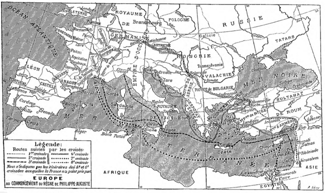
Deutsch: Karte der sechs mittelalterlichen Kreuzzüge, an denen die Franzosen teilgenommen haben, Larousse universel, 1922.
English: Map of the six medieval crusades in which the French participated, from Larousse universel, 1922.
Français : Carte des six croisades médiévales auxquelles les Français ont participé, Larousse universel en deux volumes, 1922. |
| 日期 | |
| 来源 | Scan from the Larousse 1922 by Nataraja-Shiva, also available on Gallica |
| 作者 | Larousse |
许可协议
|
本作品在其来源国以及其他著作权期限是作者逝世后70年或以下的国家和地区属于公有领域。 | |
| 本文件已被确认为免除已知的著作权法限制(包括所有相关权利)。 | |
文件历史
点击某个日期/时间查看对应时刻的文件。
| 日期/时间 | 缩略图 | 大小 | 用户 | 备注 | |
|---|---|---|---|---|---|
| 当前 | 2017年12月3日 (日) 14:33 | | 1,997 × 1,188(1.65 MB) | Mélomène | Pologne, Tatars |
| 2016年11月25日 (五) 18:35 |  | 1,997 × 1,188(1.65 MB) | Yann | much bigger size | |
| 2012年1月30日 (一) 10:34 |  | 800 × 486(485 KB) | Spiridon Ion Cepleanu | Little changes on A. Levy's map since : « Westermann Grosser Atlas zur Weltgeschichte », 1985, ISBN 3-14-100919-8, « DTV Atlas zur Weltgeschichte », 1987, ISBN 2-7242-3596-7, & « Putzger historischer Weltatlas Cornelsen » 1990, ISBN 3-464-0017 | |
| 2005年1月18日 (二) 14:57 |  | 982 × 597(179 KB) | Shizhao | from fr |
文件用途
以下8个页面使用本文件:
全域文件用途
以下其他wiki使用此文件:
- af.wikipedia.org上的用途
- de.wikipedia.org上的用途
- de.wiktionary.org上的用途
- frr.wikipedia.org上的用途
- fr.wikipedia.org上的用途
- fr.wikibooks.org上的用途
- gcr.wikipedia.org上的用途
- ja.wikipedia.org上的用途
- lmo.wikipedia.org上的用途
- mn.wikipedia.org上的用途
- mwl.wikipedia.org上的用途
- oc.wikipedia.org上的用途
- pl.wiktionary.org上的用途
- pt.wikipedia.org上的用途