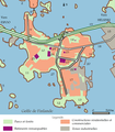
File:Lauttasaari district topo map-fr.svg

此SVG文件的PNG预览的大小:491 × 600像素。 其他分辨率:196 × 240像素 | 393 × 480像素 | 628 × 768像素 | 838 × 1,024像素 | 1,676 × 2,048像素 | 856 × 1,046像素。
原始文件 (SVG文件,尺寸为856 × 1,046像素,文件大小:239 KB)
文件历史
点击某个日期/时间查看对应时刻的文件。
| 日期/时间 | 缩略图 | 大小 | 用户 | 备注 | |
|---|---|---|---|---|---|
| 当前 | 2007年10月4日 (四) 22:34 |  | 856 × 1,046(239 KB) | Pinpin | |
| 2007年10月4日 (四) 17:36 |  | 856 × 1,046(239 KB) | Pinpin | change situation map | |
| 2007年10月4日 (四) 17:33 |  | 856 × 1,046(243 KB) | Pinpin | add text | |
| 2007年10月3日 (三) 19:12 |  | 856 × 1,046(233 KB) | Pinpin | better arrows | |
| 2007年10月3日 (三) 19:09 |  | 856 × 1,046(233 KB) | Pinpin | ||
| 2007年10月3日 (三) 19:07 |  | 856 × 1,046(233 KB) | Pinpin | little details | |
| 2007年10月3日 (三) 17:38 |  | 856 × 1,046(232 KB) | Pinpin | fini ? | |
| 2007年10月2日 (二) 19:58 |  | 855 × 1,049(119 KB) | Pinpin | ||
| 2007年10月2日 (二) 19:35 |  | 855 × 1,049(122 KB) | Pinpin | {{Information |Description={{fr}} Carte topographique du district de Lauttasaari dans le golfe de Finlande |Source=travail personnel made with Inkscape from [http://kansalaisen.karttapaikka.fi/kartanhaku/koordinaattihaku.html?cx=2548708&cy=6672017&scale=4 |
文件用途
以下页面使用本文件:
全域文件用途
以下其他wiki使用此文件:
- ca.wikipedia.org上的用途
- en.wikipedia.org上的用途
- es.wikipedia.org上的用途
- fa.wikipedia.org上的用途
- fr.wikipedia.org上的用途
- nl.wikipedia.org上的用途
- pl.wikipedia.org上的用途
- ru.wikipedia.org上的用途
- tr.wikipedia.org上的用途


