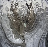
File:Aerial Photo of Monte Rosa Massif - Wallis - Switzerland.jpg

原始文件(5,442 × 5,093像素,文件大小:24.59 MB,MIME类型:image/jpeg


摘要

描述
English: Aerial Photo taken from great height of Monte Rosa Massif in canton Valais (Wallis) of Switzerland. To the left of the Monte Rosa massif is the Gornergletscher (Gorner glacier), to the right the Grenzgletscher (border glacier), both flowing in the direction of the lower border of the picture. Note: The highest peaks of the Monte Rosa massif, namely the Dufourspitze (Dufour peak) and the Nordend, are not depicted, they are lying outside of the depicted area and would be some cm upside from the upper border of the image.

Diapositiv
Form: Quadrat
Dimensions: 23 cm x 23 cm
Bildnachweis: ETH-Bibliothek Zürich, Bildarchiv/Stiftung Luftbild Schweiz
Bildcode: LBS_R1-941859
Bildnummer Bestand: R1-941859 DOI
日期
来源 https://doi.org/10.3932/ethz-a-000283925
作者 Swissair Photo AG
其他版本
相机位置45° 58′ 08.4″ 北, 7° 48′ 04.8″ 东 Kartographer map based on OpenStreetMap.在以下服务上查看本图像和附近其他图像: OpenStreetMapinfo

许可协议

w:zh:知识共享
署名 相同方式共享
本文件采用知识共享署名-相同方式共享 4.0 国际许可协议授权。
您可以自由地:
  • 共享 – 复制、发行并传播本作品
  • 修改 – 改编作品
惟须遵守下列条件:
  • 署名 – 您必须对作品进行署名,提供授权条款的链接,并说明是否对原始内容进行了更改。您可以用任何合理的方式来署名,但不得以任何方式表明许可人认可您或您的使用。
  • 相同方式共享 – 如果您再混合、转换或者基于本作品进行创作,您必须以与原先许可协议相同或相兼容的许可协议分发您贡献的作品。
注解
InfoField
该图片含有注解:在维基媒体共享资源上查看注解

说明

添加一行文字以描述该文件所表现的内容
Aerial Photo taken from great height of Monte Rosa Massif - Wallis - Switzerland

此文件中描述的项目

描绘内容

罗莎峰 中文(已转写)

戈尔纳冰川 中文(已转写)

版权状态 简体中文(已转写)

版权所有 简体中文(已转写)

视角坐标 简体中文(已转写)

45°58'8.400"N, 7°48'4.799"E

媒体类型 简体中文(已转写)

image/jpeg

校验和 简体中文(已转写)

cbb54317eef4bd3a032574de14c8a52d4504579f

断定方法:​SHA-1 简体中文(已转写)

数据大小 简体中文(已转写)

25,784,457 字节

5,093 像素

5,442 像素

文件历史

点击某个日期/时间查看对应时刻的文件。

日期/时间缩⁠略⁠图大小用户备注
当前2021年5月20日 (四) 20:072021年5月20日 (四) 20:07版本的缩略图5,442 × 5,093(24.59 MB)PittigrilliUploaded a work by Swissair Photo AG from https://doi.org/10.3932/ethz-a-000283925 with UploadWizard

没有页面使用本文件。

全域文件用途

以下其他wiki使用此文件:

元数据