File:Gabrielle 09 sept 2007 1800Z.jpg

原始文件 (5,080 × 7,200像素,文件大小:6.11 MB,MIME类型:image/jpeg


摘要

描述

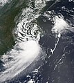
Tropical Storm Gabrielle briefly crossed land, touching North Carolina’s Outer Banks on September 9, 2007. The center of the storm came near Cape Lookout National Seashore, and after passing over Pamlico Sound briefly, headed back out to sea just twelve hours later near Kill Devil Hills. The storm system was not at all dramatic, with peak winds around 70 kilometers per hour (45 miles per hour) as it passed over the Outer Banks, according to the Associated Press. As of the afternoon of September 10, the storm was expected to stay out to sea and weaken as it crossed cooler water. In North Carolina, there were no reports of emergency calls or serious damage, and mostly the storm system was credited with light rains and some inconvenience.

The MODIS on NASA's Aqua satellite acquired this photo-like image at 2:00 p.m. local time (18:00 UTC) on September 9, 2007. The loose structure of the storm system, with only a hint of spiral structure, and the patchy clouds show that Gabrielle was not a particularly dangerous or powerful storm. However, the storm did have a discernible if not dramatic eye. Here, the eye appears over Pamlico Sound, behind the barrier of islands that forms the Outer Banks of North Carolina.
日期
来源 http://modis.gsfc.nasa.gov/gallery/individual.php?db_date=2007-09-12
作者 Jeff Schmaltz, MODIS Land Rapid Response Team, NASA GSFC
授权
(二次使用本文件)
Public domain 本文件完全由NASA创作,在美国属于公有领域。根据NASA的版权方针,NASA的材料除非另有声明否则不受版权保护。(参见Template:PD-USGov/zhNASA版权方针页面JPL图片使用方针。)
警告:

说明

添加一行文字以描述该文件所表现的内容

此文件中描述的项目

描绘内容

版权状态 简体中文(已转写)

文件历史

点击某个日期/时间查看对应时刻的文件。

日期/时间缩⁠略⁠图大小用户备注
当前2018年12月3日 (一) 22:012018年12月3日 (一) 22:01版本的缩略图5,080 × 7,200(6.11 MB)CooperScienceHigher quality, corrected color
2007年9月12日 (三) 13:412007年9月12日 (三) 13:41版本的缩略图3,556 × 4,000(2.82 MB)Good kitty== Summary == {{Information |Description=Tropical Storm Gabrielle briefly crossed land, touching North Carolina’s Outer Banks on September 9, 2007. The center of the storm came near Cape Lookout National Seashore, and after passing over Pamlico Sound br

以下页面使用本文件:

全域文件用途

以下其他wiki使用此文件:

元数据