File:Cryosphere Fuller Projection.png

預覽大小:800 × 319 像素。 其他解析度:320 × 128 像素 | 640 × 255 像素 | 1,024 × 409 像素 | 1,280 × 511 像素 | 2,703 × 1,079 像素。
原始檔案 (2,703 × 1,079 像素,檔案大小:1.03 MB,MIME 類型:image/png)
摘要
| 描述 |
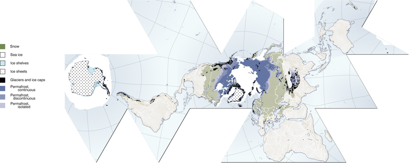
(Cryosphere) English: Author, Hugo Ahlenius, UNEP/GRID-Arendal. Full graphic, including sources, referencing etc are available here: http://maps.grida.no/go/graphic/cryosphere
.Image donated by author, no restrictions on use. Notes: Snow cover extent for Northern Hemisphere is represented by the 1966-2005 February average, for Southern Hemisphere by the 1987-2003 August average. Sea ice extent for Northern Hemisphere is represented by the 1979-2003 March average, for Southern Hemisphere by the 1979-2002 September average. Permafrost data for mountain areas and for the Southern Hemisphere are not represented in this map, neither are river and lake ice. Data sources: Armstrong, R.L. and Brodzik, M.J. (2005). Northern Hemisphere EASE-Grid weekly snow cover and sea ice extent version 3. (Digital media). National Snow and Ice Data Center, Boulder Armstrong, R.L., Brodzik, M.J., Knowles, K. and Savoie, M. (2005). Global monthly EASE-Grid snow water equivalent climatology. (Digital media). National Snow and Ice Data Center, Boulder Brown, J., Ferrians Jr., O.J., Heginbottom, J.A. and Melnikov, E.S. (1998 revised February 2001). Circum-Arctic map of permafrost and ground-ice conditions. (Digital media). National Snow and Ice Data Center/World Data Center for Glaciology, Boulder NGA (2000). Vector Map Level 0. National Geospatial-Intelligence Agency. http://geoengine.nima.mil/ftpdir/archive/vpf_ data/v0soa.tar.gz [Accessed 1 September 2006] Stroeve, J. and Meier, W. (1999, updated 2005). Sea Ice Trends and Climatologies from SMMR and SSM/I. National Snow and Ice Data Center. http://nsidc.org/data/smmr_ssmi_ ancillary/monthly_means.html [Accessed 20 April 2007] |
| 日期 | 2007年6月12日 (原始上傳日期) |
| 來源 |
http://www.grida.no/graphicslib/detail/the-cryosphere-world-map_e290 Transferred from en.wikipedia to Commons by Pixeltoo using CommonsHelper. |
| 作者 | 英文維基百科的Fraxen |
授權條款

|
已授權您依據自由軟體基金會發行的無固定段落、封面文字和封底文字GNU自由文件授權條款1.2版或任意後續版本,對本檔進行複製、傳播和/或修改。該協議的副本列在GNU自由文件授權條款中。 |
| 此檔案採用創用CC 姓名標示-相同方式分享 3.0 未在地化版本授權條款。 | ||
| 姓名標示: 英文維基百科的Fraxen | ||
| ||
| 已新增授權條款標題至此檔案,作為GFDL授權更新的一部份。 |
您可以選擇您需要的授權條款。
原始上傳日誌
The original description page was here. All following user names refer to en.wikipedia.
- 2007-06-12 08:06 Fraxen 2703×1079× (1080674 bytes)
- 2007-06-12 08:04 Fraxen 500×200× (73656 bytes)
- 2007-06-12 08:00 Fraxen 2703×1079× (1080674 bytes) Author, Hugo Ahlenius, UNEP/GRID-Arendal. Full graphic, including sources, referencing etc are available here: http://maps.grida.no/go/graphic/cryosphere Image donated by author, no restrictions on use. Notes: Snow cover extent for Northern Hemisphere is
檔案歷史
點選日期/時間以檢視該時間的檔案版本。
| 日期/時間 | 縮圖 | 尺寸 | 使用者 | 備註 | |
|---|---|---|---|---|---|
| 目前 | 2014年12月3日 (三) 16:48 | 2,703 × 1,079(1.03 MB) | Gabrielsanz | Added the areas of glaciers and ice sheet in Sierra Nevada de Mérida (see Pico Bolívar, Pico Humboldt and [[Category:Glaciers of Venezuela|Glacier... | |
| 2014年12月3日 (三) 15:57 | 2,703 × 1,079(1.03 MB) | Gabrielsanz | Added the area of glaciers and ice cap located in Sierra Nevada de Mérida (see Pico Bolívar and Pico Humboldt) | ||
| 2008年11月23日 (日) 10:56 | 2,703 × 1,079(1.03 MB) | File Upload Bot (Magnus Manske) | {{BotMoveToCommons|en.wikipedia}} {{Information |Description={{en|Author, Hugo Ahlenius, UNEP/GRID-Arendal. Full graphic, including sources, referencing etc are available here: http://maps.grida.no/go/graphic/cryosphere Image donated by author, no restri |
檔案用途
下列頁面有用到此檔案:
全域檔案使用狀況
以下其他 wiki 使用了這個檔案:
- ar.wikipedia.org 的使用狀況
- ast.wikipedia.org 的使用狀況
- az.wikipedia.org 的使用狀況
- ca.wikipedia.org 的使用狀況
- el.wikipedia.org 的使用狀況
- en.wikipedia.org 的使用狀況
- en.wikiversity.org 的使用狀況
- User:Marshallsumter/Rocks/Glaciers/Astroglaciology
- User:Marshallsumter/Rocks/Glaciers/Astroglaciology/Quiz
- Callisto/Quiz
- User:Marshallsumter/Rocks/Ice sheets/Europa/Quiz
- User:Marshallsumter/Rocks/Rocky objects/Ganymede/Quiz
- Stars/Solar systems/Quiz
- User:Marshallsumter/Rocks/Rocky objects/Earth
- Minerals/Ices/Brittle ices/Quiz
- User:Marshallsumter/Rocks/Glaciers/Quiz
- User:Marshallsumter/Rocks/Glaciers/Glaciology/Quiz
- User:Marshallsumter/Rocks/Ice sheets/Enceladus/Quiz
- Minerals/Ices/Black ices/Quiz
- Ice sheets/Quiz
- User:Marshallsumter/Radiation astronomy/Earth
- es.wikipedia.org 的使用狀況
- et.wikipedia.org 的使用狀況
- eu.wikipedia.org 的使用狀況
- fa.wikipedia.org 的使用狀況
- fr.wikipedia.org 的使用狀況
- id.wikipedia.org 的使用狀況
- it.wikipedia.org 的使用狀況
- ja.wikipedia.org 的使用狀況
- ka.wikipedia.org 的使用狀況
- la.wikipedia.org 的使用狀況
- nn.wikipedia.org 的使用狀況
- om.wikipedia.org 的使用狀況
- ro.wikipedia.org 的使用狀況
- si.wikipedia.org 的使用狀況
- sr.wikipedia.org 的使用狀況
- th.wikipedia.org 的使用狀況
- tr.wikipedia.org 的使用狀況
- uk.wikipedia.org 的使用狀況
- ur.wikipedia.org 的使用狀況
- vi.wikipedia.org 的使用狀況
- zu.wikipedia.org 的使用狀況