File:First 360 color panorama from the Curosity rover.jpg

預覽大小:798 × 196 像素。 其他解析度:320 × 79 像素 | 640 × 157 像素 | 1,024 × 252 像素 | 1,280 × 314 像素 | 2,560 × 629 像素 | 14,494 × 3,560 像素。
原始檔案 (14,494 × 3,560 像素,檔案大小:6.18 MB,MIME 類型:image/jpeg)
摘要
| 描述 |
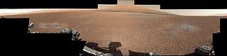
English: This color panorama shows a 360-degree view of the landing site of NASA's Curiosity rover, including the highest part of Mount Sharp visible to the rover. That part of Mount Sharp is approximately 12 miles (20 kilometers) away from the rover.
The images were obtained by the rover's 34-millimeter Mast Camera. The mosaic, which stretches about 29,000 pixels across by 7,000 pixels high, includes 130 images taken on Aug. 8 and an additional 10 images taken on Aug. 18. These images were shot before the camera was fully characterized. Scientists enhanced the color in one version to show the Martian scene as it would appear under the lighting conditions we have on Earth, which helps in analyzing the terrain. A raw version is also available. |
| 日期 | |
| 來源 | http://photojournal.jpl.nasa.gov/catalog/PIA16029 |
| 作者 | NASA/JPL-Caltech/MSSS |
| 其他版本 | File:Gale Crater landing site-2012.jpg (cropped) |
| 360° | 瀏覽環景圖請使用360° 環景瀏覽器
|
|---|
授權條款
| 本作品由NASA創作,屬於公有領域。根據NASA的版權政策:“NASA的創作除非另有聲明否則不受版權保護。”(參見:Template:PD-USGov/zh,NASA版權政策或JPL圖像使用政策) | ||
 |
警告:
|
| 此標籤不表示文件的著作權狀態。任何文件在附有此標籤的同時還需要一個有效的著作權標籤。請參閱許可協議說明頁面以了解更多資訊。 其他語言:
|
檔案歷史
點選日期/時間以檢視該時間的檔案版本。
| 日期/時間 | 縮圖 | 尺寸 | 使用者 | 備註 | |
|---|---|---|---|---|---|
| 目前 | 2012年8月28日 (二) 02:14 | 14,494 × 3,560(6.18 MB) | Rehman | replacing low-res PIA16029, with high-res PIA16101 | |
| 2012年8月9日 (四) 18:04 | 3,653 × 755(265 KB) | Rehman |
檔案用途
全域檔案使用狀況
以下其他 wiki 使用了這個檔案:
- bn.wikipedia.org 的使用狀況
- ca.wikipedia.org 的使用狀況
- cs.wikipedia.org 的使用狀況
- de.wikipedia.org 的使用狀況
- en.wikipedia.org 的使用狀況
- es.wikipedia.org 的使用狀況
- fa.wikipedia.org 的使用狀況
- fr.wikipedia.org 的使用狀況
- hr.wikipedia.org 的使用狀況
- kk.wikipedia.org 的使用狀況
- ko.wikipedia.org 的使用狀況
- pl.wikipedia.org 的使用狀況
- ro.wikipedia.org 的使用狀況
- ru.wikipedia.org 的使用狀況
- sr.wikipedia.org 的使用狀況
- sr.wikinews.org 的使用狀況
- test.wikipedia.org 的使用狀況
- uk.wikipedia.org 的使用狀況